Dhour El Choueir
| Dhour El Choueir ضهور الشوير | |
|---|---|
| City | |
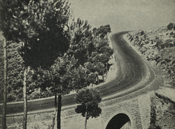 Dhour El Choueir road - 1947 | |
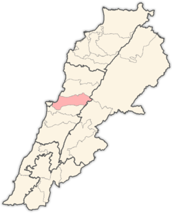
 Dhour El Choueir Location within Lebanon | |
| Coordinates: 33°54′43.32″N 35°42′32.54″E / 33.9120333°N 35.7090389°ECoordinates: 33°54′43.32″N 35°42′32.54″E / 33.9120333°N 35.7090389°E | |
| Country |
|
| Governorate | Mount Lebanon Governorate |
| District | Matn District |
| Elevation | 1,200 m (3,900 ft) |
| Time zone | UTC+2 (EET) |
| • Summer (DST) | UTC+3 (EEST) |
| Dialing code | +961 |
Dhour El Choueir (Arabic: ضهور الشوير) is a mountain town in Lebanon ('dhour' meaning 'summit, top [of a mountain]'). It lies slightly north of the main Beirut - Damascus highway. It overlooks the city of Beirut and the Mediterranean sea. It is 30 km from Beirut and 42 km from Beirut International Airport.
It is one of Mount Lebanon's favored summer resorts extraordinary fresh air Dhour El-Choueir is important for its August yearly carnival, honoring Lebanon's emigrants.
The Greek Catholic monk Abdallah Zakher set up an Arabic language printing press using movable type at the monastery of Saint John at Choueir, the first homemade press in Lebanon. He personally cut the type molds and did the founding of the elegant typeface. He created the first true Arabic script type in the Middle East. The first book off the Zakhir press was printed in 1734; this press continued to be used until 1899.[1]
It is the birthplace of Anton Saadeh who founded the Syrian Social Nationalist Party[2] and of Tanios Bou-Nader Khneisser, the father of the Sword & Shield Folkloric Dance.
The town was on the front line during the Lebanese Civil War. Half of the population is Eastern Orthodox and the other half is mostly Melkite and Maronite.
References
External links
Capital: Jdeideh | ||
| Towns and villages |
|  |
| Notable landmarks | ||
| Notable touristic sites | ||