Dale Street Warehouse
| Dale Street Warehouse | |
|---|---|
 Dale Street (now Carver's) Warehouse | |
| General information | |
| Architectural style | warehouse |
| Town or city | Manchester |
| Country | United Kingdom |
| Completed | 1806 |
| Design and construction | |
| Architect | William Crosley |
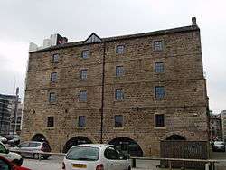
Dale Street Warehouse is an early nineteenth century warehouse in the Piccadilly Basin area of Manchester city centre. It is a Grade II* listed building as of 10 November 1972.[1] "It is of considerable interest as the earliest surviving canal warehouse in the city" according to Clare Hartwell.[2] The building is dated 1806 with initials "WC" on the datestone indicating that it was designed by William Crosley,[3] an engineer who worked with William Jessop on the inner-Manchester canal system. Constructed of watershot millstone grit blocks, the four-storey building has timber floors, supported throughout by cast-iron columns, a feature which now makes it unique amongst Manchester warehouses.[3] The base of the building incorporates four boatholes which allowed boats to unload their cargoes inside of the warehouse. The warehouse also incorporates a "subterranean wheel-pit containing a 16-foot water-wheel used to drive hoists both in this building and in a former warehouse to the south via a line-shaft tunnel which mostly survives beneath the car-park."[1] For many years the building was a shop and was described in 2000 as "sadly neglected";[4] the warehouse has now been converted to office space and a café and renamed Carver's Warehouse.
See also
Notes
- 1 2 "Dale Warehouse, Manchester". British Listed Buildings. Retrieved 14 May 2011.
- ↑ Clare Hartwell, Pevsner Architectural Guides: Manchester; p. 219
- 1 2 Hartwell, Clare; Hyde, Matthew; Pevsner, Nikolaus (2004). The Buildings of England - Lancashire: Manchester and the South East. Yale University Press. p. 304. ISBN 978-0-300-10583-4.
- ↑ John J. Parkinson-Bailey Manchester: an Architectural History, p. 323
References
- Pevsner, Nikolaus; Hartwell, Clare & Hyde, Matthew, The Buildings of England: Lancashire - Manchester and the South East (2004) Yale University Press
- Hartwell, Claire Pevsner Architectural Guides: Manchester (2001) Yale University Press
Coordinates: 53°28′49″N 2°13′55″W / 53.48026°N 2.23196°W