Church of St Michael and All Angels, Northenden
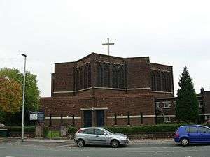
The Church of St Michael and All Angels, Orton Road, Lawton Moor, Northenden, Manchester, is an Anglican church of 1935-7 by N.F.Cachemaille-Day.[1] Pevsner describes the church as "sensational for its country and its time".[1] The church was designated a Grade II* listed building on 16 January 1981.[2]
The Corporation of Manchester acquired the Wythenshawe Estate in 1926 and began laying out the garden suburb in 1930. Covering 5,000 acres (2,000 ha), it was eventually to have 25,000 houses and a population of 100,000. The garden suburb was designated part of the parish of Church of St Wilfrid, Northenden but that small parish church proved insufficient to accommodate the rising congregation. A mission church was therefore opened in 1934, and in 1935 the diocese approved plans for the construction of a new parish church at Orton Road. The budget was £10,000.[3] Nugent Francis Cachemaille-Day was appointed as architect for both the church and the adjoining parsonage. The foundation stone for the church was laid on 8 May 1937, by the Bishop of Manchester. The builder was J. Clayton and Sons of Denton.[3]
The plan of the church is a star, comprising two inter-locked squares.[1] It is built of "red brick in English bond with some stone dressings".[2] The roof is flat with a cross in the centre.[1]
The interior is "raw but spatially subtle".[1] It has an "ingenious plan with lofty columns supporting [a] flat ribbed roof".[2] The plans show the long-held tradition that Cachemaille-Day intended to place the altar in the centre of the building is not correct.[1]
See also
References
Sources
- Hartwell, Clare; Hyde, Matthew; Pevsner, Nikolaus (2004), Lancashire: Manchester and the South East, The Buildings of England, New Haven, CT; London: Yale University Press, ISBN 0-300-10583-5
Coordinates: 53°24′36″N 2°16′56″W / 53.4099°N 2.2821°W