List of municipalities in Prince Edward Island
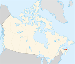

Prince Edward Island is the least populous province in Canada with 142,907 residents as of 2016 and is the smallest in land area at 5,686 km2 (2,195 sq mi).[1] Prince Edward Island's 72 municipalities were home to 70% of its population in 2016. These municipalities provide local government services to their residents in the form of fire protection, municipal planning services, and emergency measures planning.[2] The remaining unincorporated areas have no local government.[3]
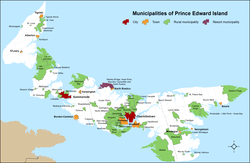
Municipal statuses in Prince Edward Island include cities, towns, rural municipalities, and resort municipalities.[4] Under Prince Edward Island's Municipal Government Act of 2016, which came into force on December 23, 2017,[5] the formation of a municipality can be proposed by the Minister of Communities, Land and Environment (CLE), the council of an existing municipality, or a petition signed by 30% of the residents that would be the electors of the new municipality.[2] To be eligible for city or town status, certain minimum estimated population and total property assessment value criteria must be met.[2] If those criteria are not met, rural municipality status can be granted if it is the opinion of the Minister of CLE that it would be in the public interest.[2] The province's lone resort municipality that was established by order in council in 1990 continues as such in the Municipal Government Act but no new resort municipalities may be created.[4]
Prince Edward Island has 2 cities, 11 towns, 58 communities and 1 resort municipality,[4][6] which are distributed across three counties – Kings, Prince and Queens. Approximately 26% of residents live in the provincial capital of Charlottetown and another 24% live within the Charlottetown census agglomeration.[7]
Municipalities
Cities
Under the province's Municipal Government Act, a municipality may incorporate as a city if has an estimated population that meets or exceeds 15,000 and a total property assessment value that meets or exceeds $750-million.[2][4] Prince Edward Island has two cities.[6] Charlottetown is Prince Edward Island's capital and largest city both by population with 36,094 residents and by land area with 44.34 km2 (17.12 sq mi).[7] It forms the core of a census agglomeration that encompasses the middle of the island and is home to 69,325 residents, or 49% of the island's population.[8] The province's second city is Summerside, which is located on the west side of the island. It has a population of 14,829 and a land area of 28.49 km2 (11.00 sq mi).[7] Starting with the municipal elections in 2018, the cities will elect a mayor and eight councillors, though this could be increased to a mayor and ten councillors if enacted by municipal bylaw.[4]
Towns
Under the province's Municipal Government Act, a municipality may incorporate as a town if has an estimated population that meets or exceeds 4,000 but is less than 15,000, and a total property assessment value that meets or exceeds $200-million, but is less than $750-million.[2][4] Prince Edward Island has eleven towns that are incorporated municipalities,[6] which had a cumulative population of 24,252 in the 2016 Census.[7] The province's largest and smallest towns are Stratford and Georgetown with populations of 9,706 and 555 respectively.[7] Cornwall is Prince Edward Island's largest town by land area with 28.19 km2 (10.88 sq mi) and Georgetown is the province's smallest town by land area with 1.59 km2 (0.61 sq mi).[7] The province's newest town is Tignish, which changed to town status on April 1, 2017.[9] Starting with the municipal elections in 2018, the towns will elect a mayor and six councillors, though this could be increased to a mayor and eight councillors if enacted by municipal bylaw.[4]
Rural municipalities
Under the province's Municipal Government Act, municipalities that previously held community status under the previous Municipalities Act were carried forward as rural municipalities.[2][4][lower-alpha 1] With the amalgamation of Brackley and Winsloe South on December 15, 2017,[11] and then the Municipal Government Act coming into force eight days later on December 23, 2017,[5] Prince Edward Island had 58 communities that became rural municipalities.[4][12] As of the 2016 census, the province's largest and smallest communities are Belfast and Tignish Shore with populations of 1,670 and 57 respectively.[7][6] Starting with the municipal elections in 2018, the rural municipalities will elect a mayor and six councillors, though this could be increased to a mayor and eight councillors if enacted by municipal bylaw.[4]
Resort municipalities
Prince Edward Island has one municipality holding resort municipality status. The Resort Municipality of Stanley Bridge, Hope River, Bayview, Cavendish and North Rustico was established as a resort municipality in 1990.[2] The province's Municipal Government Act allows this resort municipality to continue yet prevents the establishment of additional resort municipalities in the future.[2][4] Starting with the municipal elections in 2018, the province's lone resort municipality will elect a mayor and six councillors, though this could be increased to a mayor and eight councillors if enacted by municipal bylaw.[4]
List
| Name | County | Municipal status[4][6] |
Incorporation year[13] |
2016 Census of Population | ||||
|---|---|---|---|---|---|---|---|---|
| Population (2016)[7][6] |
Population (2011)[7][12] |
Change | Land area (km²)[7][12] |
Population density[7] | ||||
| Charlottetown | Queens | City | 1855[lower-alpha 2] | 36,094 | 34,562 | +4.4% | 44.34 | 814.0/km2 |
| Summerside | Prince | City | 1877[lower-alpha 3] | 14,829 | 14,751 | +0.5% | 28.49 | 520.5/km2 |
| Alberton | Prince | Town | 1913 | 1,145 | 1,135 | +0.9% | 4.52 | 253.3/km2 |
| Borden-Carleton | Prince | Town | 1995[lower-alpha 4] | 724 | 750 | −3.5% | 12.99 | 55.7/km2 |
| Cornwall | Queens | Town | 1995 | 5,348 | 5,162 | +3.6% | 28.19 | 189.7/km2 |
| Georgetown | Kings | Town | 1912 | 555 | 675 | −17.8% | 1.59 | 349.1/km2 |
| Kensington | Prince | Town | 1914 | 1,619 | 1,513 | +7.0% | 3.01 | 537.9/km2 |
| Montague | Kings | Town | 1917 | 1,961 | 1,895 | +3.5% | 3.16 | 620.6/km2 |
| North Rustico | Queens | Town | 1954[lower-alpha 5] | 607 | 583 | +4.1% | 2.41 | 251.9/km2 |
| O'Leary | Prince | Town | 1951[lower-alpha 6] | 815 | 812 | +0.4% | 1.68 | 485.1/km2 |
| Souris | Kings | Town | 1910 | 1,053 | 1,173 | −10.2% | 3.47 | 303.5/km2 |
| Stratford | Queens | Town | 1995 | 9,706 | 8,574 | +13.2% | 22.53 | 430.8/km2 |
| Tignish | Prince | Town[9] | 1952[lower-alpha 7] | 719 | 779 | −7.7% | 5.87 | 122.5/km2 |
| Abram-Village | Prince | Rural municipality | 1974 | 272 | 267 | +1.9% | 1.26 | 215.9/km2 |
| Afton | Queens | Rural municipality | 1974 | 1,291 | 1,222 | +5.6% | 39.8 | 32.4/km2 |
| Alexandra | Queens | Rural municipality | 1972 | 221 | 224 | −1.3% | 10.4 | 21.3/km2 |
| Annandale-Little Pond-Howe Bay | Kings | Rural municipality | 1975 | 211 | 262 | −19.5% | 31.8 | 6.6/km2 |
| Bedeque and Area | Prince | Rural municipality | 2014 | 302 | 310 | −2.6% | 2.53 | 119.4/km2 |
| Belfast | Queens | Rural municipality | 1972 | 1,670 | 1,637 | +2.0% | 229.6 | 7.3/km2 |
| Bonshaw | Queens | Rural municipality | 1977 | 187 | 218 | −14.2% | 14.0 | 13.4/km2 |
| Brackley | Queens | Rural municipality | 1983[lower-alpha 8] | 596 | 561 | +6.2% | 18.38 | 32.4/km2 |
| Breadalbane | Queens | Rural municipality | 1991 | 167 | 173 | −3.5% | 12.55 | 13.3/km2 |
| Brudenell | Kings | Rural municipality | 1973 | 371 | 362 | +2.5% | 20.4 | 18.2/km2 |
| Cardigan | Kings | Rural municipality | 1954 | 269 | 332 | −19.0% | 5.12 | 52.5/km2 |
| Central Kings | Kings | Rural municipality | 1975 | 339 | 329 | +3.0% | 73.7 | 4.6/km2 |
| Clyde River | Queens | Rural municipality | 1974 | 653 | 576 | +13.4% | 16.52 | 39.5/km2 |
| Crapaud | Queens | Rural municipality | 1950 | 319 | 345 | −7.5% | 2.15 | 148.4/km2 |
| Darlington | Queens | Rural municipality | 1983 | 91 | 109 | −16.5% | 7.7 | 11.8/km2 |
| Eastern Kings | Kings | Rural municipality | 1974 | 709 | 702 | +1.0% | 141.0 | 5.0/km2 |
| Ellerslie-Bideford | Prince | Rural municipality | 1977 | 348 | 357 | −2.5% | 20.8 | 16.7/km2 |
| Grand Tracadie | Queens | Rural municipality | 1984 | 294 | 293 | +0.3% | 12.2 | 24.1/km2 |
| Greenmount-Montrose | Prince | Rural municipality | 1977 | 266 | 258 | +3.1% | 25.8 | 10.3/km2 |
| Hampshire | Queens | Rural municipality | 1974 | 335 | 420 | −20.2% | 13.6 | 24.6/km2 |
| Hazelbrook | Queens | Rural municipality | 1974 | 183 | 172 | +6.4% | 8.1 | 22.6/km2 |
| Hunter River | Queens | Rural municipality | 1974 | 356 | 294 | +21.1% | 5.97 | 59.6/km2 |
| Kingston | Queens | Rural municipality | 1974 | 1,096 | 794 | +38.0% | 48.0 | 22.8/km2 |
| Kinkora | Prince | Rural municipality | 1955 | 336 | 339 | −0.9% | 3.82 | 88.0/km2 |
| Lady Slipper | Prince | Rural municipality | 1983 | 764 | 805 | −5.1% | 112.4 | 6.8/km2 |
| Linkletter | Prince | Rural municipality | 1972 | 310 | 320 | −3.1% | 9.08 | 34.1/km2 |
| Lorne Valley | Kings | Rural municipality | 1978 | 95 | 106 | −10.4% | 17.7 | 5.4/km2 |
| Lot 11 and Area | Prince | Rural municipality | 1982 | 613 | 635 | −3.5% | 101.4 | 6.0/km2 |
| Lower Montague | Kings | Rural municipality | 1974 | 598 | 665 | −10.1% | 21.8 | 27.4/km2 |
| Malpeque Bay | Queens | Rural municipality | 1973 | 1,030 | 1,029 | +0.1% | 96.7 | 10.7/km2 |
| Meadowbank | Queens | Rural municipality | 1974 | 355 | 338 | +5.0% | 9.29 | 38.2/km2 |
| Miltonvale Park | Queens | Rural municipality | 1974 | 1,148 | 1,153 | −0.4% | 35.45 | 32.4/km2 |
| Miminegash | Prince | Rural municipality | 1968 | 148 | 173 | −14.5% | 1.90 | 77.9/km2 |
| Miscouche | Prince | Rural municipality | 1957 | 873 | 869 | +0.5% | 3.45 | 253.0/km2 |
| Morell | Kings | Rural municipality | 1953 | 297 | 313 | −5.1% | 1.46 | 203.4/km2 |
| Mount Stewart | Queens | Rural municipality | 1953 | 209 | 225 | −7.1% | 1.22 | 171.3/km2 |
| Murray Harbour | Kings | Rural municipality | 1953 | 258 | 320 | −19.4% | 3.89 | 66.3/km2 |
| Murray River | Kings | Rural municipality | 1955 | 304 | 334 | −9.0% | 1.47 | 206.8/km2 |
| New Haven-Riverdale | Queens | Rural municipality | 1974 | 520 | 485 | +7.2% | 21.7 | 24.0/km2 |
| North Shore | Queens | Rural municipality | 1974 | 1,294 | 1,112 | +16.4% | 45.4 | 28.5/km2 |
| North Wiltshire | Queens | Rural municipality | 1974 | 189 | 182 | +3.8% | 12.3 | 15.4/km2 |
| Northport | Prince | Rural municipality | 1974 | 186 | 188 | −1.1% | 1.8 | 103.3/km2 |
| Pleasant Grove | Queens | Rural municipality | 1980 | 492 | 496 | −0.8% | 13.6 | 36.2/km2 |
| Sherbrooke | Prince | Rural municipality | 1972 | 159 | 172 | −7.6% | 8.85 | 18.0/km2 |
| Souris West | Kings | Rural municipality | 1972 | 399 | 399 | 0.0% | 7.7 | 51.8/km2 |
| St. Felix | Prince | Rural municipality | 1977 | 333 | 348 | −4.3% | 11.4 | 29.2/km2 |
| St. Louis | Prince | Rural municipality | 1964 | 66 | 51 | +29.4% | 0.62 | 106.5/km2 |
| St. Nicholas | Prince | Rural municipality | 1991 | 211 | 198 | +6.6% | 20.6 | 10.2/km2 |
| St. Peters Bay | Kings | Rural municipality | 1953 | 237 | 253 | −6.3% | 4.27 | 55.5/km2 |
| Tignish Shore | Prince | Rural municipality | 1975 | 57 | 73 | −21.9% | 1.5 | 38.0/km2 |
| Tyne Valley | Prince | Rural municipality | 1966 | 249 | 222 | +12.2% | 1.72 | 144.8/km2 |
| Union Road | Queens | Rural municipality | 1977 | 204 | 235 | −13.2% | 9.97 | 20.5/km2 |
| Valleyfield | Kings | Rural municipality | 1974 | 670 | 672 | −0.3% | 78.6 | 8.5/km2 |
| Victoria | Queens | Rural municipality | 1951 | 74 | 104 | −28.8% | 1.46 | 50.7/km2 |
| Warren Grove | Queens | Rural municipality | 1985 | 356 | 367 | −3.0% | 10.18 | 35.0/km2 |
| Wellington | Prince | Rural municipality | 1959 | 415 | 409 | +1.5% | 1.78 | 233.1/km2 |
| West River | Queens | Rural municipality | 1974 | 801 | 741 | +8.1% | 34.8 | 23.0/km2 |
| York | Queens | Rural municipality | 1986 | 408 | 284 | +43.7% | 12.4 | 32.9/km2 |
| Stanley Bridge, Hope River, Bayview, Cavendish and North Rustico[lower-alpha 9] | Queens | Resort municipality | 1990 | 328 | 266 | +23.3% | 37.79 | 8.7/km2 |
| Total cities | – | – | – | 50,923 | 49,313 | +3.3% | 72.83 | 699.2/km2 |
| Total towns | – | – | – | 24,252 | 23,051 | +5.2% | 89.42 | 290.3/km2 |
| Total rural municipalities | – | – | – | 25,204 | 24,832 | +1.5% | 1,483.06 | 17.0/km2 |
| Total resort municipalities | – | – | – | 328 | 266 | +23.3% | 37.79 | 8.7/km2 |
| Total municipalities | – | – | – | 100,707 | 97,462 | +3.3% | 1,683.10 | 59.8/km2 |
| Province of Prince Edward Island | – | – | – | 142,907 | 140,204 | +1.9% | 5,686.03 | 25.1/km2 |
See also
Notes
- ↑ Prior to the Municipalities Act, incorporated communities were previously designated either villages or community improvement committees.[10]
- ↑ On April 1, 1995, the Charlottetown Area Municipalities Act incorporated the adjacent municipalities of Parkdale, Sherwood, Hillsborough Park, Winsloe, West Royalty, and East Royalty.[14]
- ↑ Summerside incorporated as a city in 1995.[15]
- ↑ Borden-Carlton incorporated as a town on July 31, 2012.[16]
- ↑ North Rustico incorporated as a town on November 16, 2013.[17]
- ↑ O'Leary incorporated as a town on March 11, 2014.[18]
- ↑ Tignish incorporated as a town on April 1, 2017.[9]
- ↑ Brackley amalgamated with Winsloe South on December 15, 2017.[11] Winsloe South originally incorporated in 1986.[19]
- ↑ Official legal name is the "Resort Municipality of Stanley Bridge, Hope River, Bayview, Cavendish and North Rustico.[2]
References
- ↑ "Population and dwelling counts, for Canada, provinces and territories, 2016 and 2011 censuses – 100% data". Statistics Canada. August 28, 2017. Retrieved December 27, 2017.
- 1 2 3 4 5 6 7 8 9 10 "Chapter 44 (Bill No. 58): Municipal Government Act" (PDF). Prince Edward Island Queen's Printer. December 15, 2016. Retrieved December 26, 2017.
- ↑ "Canada – Prince Edward Island Agreement Municipal Strategic Component 2014 - 2019 Guidelines and Criteria" (PDF). Government of Prince Edward Island. March 2016. Retrieved December 29, 2017.
- 1 2 3 4 5 6 7 8 9 10 11 12 13 "Existing Municipalities and New Municipalities – Municipal Government Act". Government of Prince Edward Island. January 6, 2017. Retrieved December 26, 2017.
- 1 2 "EC2017-747: Municipal Government Act Proclamation" (PDF). Prince Edward Island Executive Council. December 12, 2017. p. 414. Retrieved December 26, 2017.
- 1 2 3 4 5 6 "Prince Edward Island Municipal Boundaries" (PDF). Prince Edward Island Communities, Land and Environment. December 23, 2017. Retrieved December 29, 2017.
- 1 2 3 4 5 6 7 8 9 10 11 "Population and dwelling counts, for Canada, provinces and territories, and census subdivisions (municipalities), 2016 and 2011 censuses – 100% data (Prince Edward Island)". Statistics Canada. February 8, 2017. Retrieved February 11, 2017.
- ↑ "Census Profile, 2016 Census: Charlottetown [Census agglomeration], Prince Edward Island and Prince Edward Island [Province]". Statistics Canada. November 16, 2017. Retrieved December 27, 2017.
- 1 2 3 Kevin Yarr (March 29, 2017). "Tignish to become a town". CBC. Retrieved December 25, 2017.
- ↑ "Municipalities Act" (PDF). Legislative Counsel Office. December 6, 2013. Retrieved November 1, 2014.
- 1 2 "EC2017-746: Municipalities Act (Community of Brackley and Community of Winsloe South Amalgamation)" (PDF). Prince Edward Island Executive Council. December 12, 2017. pp. 413&ndash, 414. Retrieved December 26, 2017.
- 1 2 3 "Prince Edward Island Municipal Boundaries" (PDF). Prince Edward Island Communities, Land and Environment. January 2016. Retrieved December 29, 2016.
- ↑ "Municipal Affairs and Provincial Planning". Department of Finance, Energy and Municipal Affairs. Archived from the original on December 8, 2015. Retrieved February 7, 2015.
- ↑ "PlaceFinder Charlottetown, Prince Edward Island". Government of Prince Edward Island. Retrieved December 29, 2017.
- ↑ "PlaceFinder Summerside, Prince Edward Island". Government of Prince Edward Island. Retrieved December 29, 2017.
- ↑ "EC2012-443: Municipalities Act (Community of Borden-Carleton Change of Status of Municipality from Community to Town Approved)" (PDF). Prince Edward Island Executive Council. July 31, 2012. p. 261. Retrieved November 24, 2013.
- ↑ "EC2013-782: Municipalities Act (Community of North Rustico Change of Status of Municipality from Community to Town Approved)" (PDF). Prince Edward Island Executive Council. November 5, 2013. p. 532. Retrieved November 24, 2013.
- ↑ "EC2014-142: Municipalities Act (Community of O'Leary Change of Status of Municipality from Community to Town Approved)" (PDF). Prince Edward Island Executive Council. March 11, 2014. p. 72. Retrieved December 29, 2017.
- ↑ "PlaceFinder Winsloe South, Prince Edward Island". Government of Prince Edward Island. Retrieved December 29, 2017.
External links
| Wikimedia Commons has media related to Prince Edward Island. |
- Federation of Prince Edward Island Municipalities
- Government of Prince Edward Island: Department of Communities, Land and Environment
- Municipalities – Department of Communities, Land and Environment
| Subdivisions | |
|---|---|
| Cities | |
| Towns | |
| Rural municipalities |
|
| Unincorporated communities | |
| |
| Provinces | |
|---|---|
| Territories | |
| |