Coorong National Park
| Coorong National Park South Australia | |
|---|---|
|
IUCN category II (national park) | |
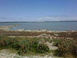 The view across the Coorong near Salt Creek | |
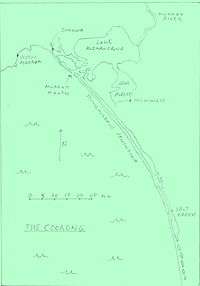 A map of the Coorong | |
 Coorong National Park | |
| Nearest town or city | Goolwa |
| Coordinates | 36°02′57″S 139°33′13″E / 36.04917°S 139.55361°ECoordinates: 36°02′57″S 139°33′13″E / 36.04917°S 139.55361°E |
| Established | 9 November 1967[1] |
| Area | 490.15 km2 (189.2 sq mi)[2] |
| Managing authorities | Department of Environment, Water and Natural Resources |
| Website | Coorong National Park |
| Footnotes | |
| Official name | The Coorong, Lake Alexandrina & Albert Wetland |
| Designated | 1 November 1985 |
| Reference no. | 321[3] |
| See also | Protected areas of South Australia |
The Coorong National Park is a protected area located in South Australia about 156 kilometres (97 mi) southeast of Adelaide and that predominantly covers a lagoon ecosystem officially known as the Coorong and the Younghusband Peninsula on the Coorong's southern side.
Etymology
Its name is thought to be a corruption of the local Aboriginal people's word kurangh, meaning "long neck"; a reference to the shape of the lagoon system. The name is also thought to be from the Aboriginal word Coorang, "sand dune", a reference to the sand dunes that form the Younghusband Peninsula.
Description
The western end of the Coorong lagoon is at the Murray Mouth near Hindmarsh Island and the Sir Richard Peninsula, and it extends about 130 kilometres (81 mi) southeast. The national park area includes the Coorong itself, and Younghusband Peninsula which separates the Coorong from Encounter Bay in the Southern Ocean. The Coorong has been cut off from Lake Alexandrina by the construction of the Goolwa Barrages (weirs) from Goolwa to Pelican Point during the late 1930s.[4]
The national park was formed in 1967 as a sanctuary for many species of birds, animals and fish. It attracts many migratory species. It provides refuge for these animals during some of Australia's regular droughts. The 467 square kilometres (180 sq mi) also supports coastal dune systems, lagoons and coastal vegetation.[5]
One of the unique aspects of the Coorong is the interaction of water along its length, with sea water and Murray River water meeting rainfall and groundwater. The freshwater supports the fauna (animal) of the area while the sea water is the habitat for much of the birdlife.[6]
The waters of the Coorong are a popular venue for recreational and commercial fishers. The popular 'Coorong Mullet' and 'school mulloway' are the main species. The region was the setting of the popular 1977 film Storm Boy.
History
The Coorong National Park was proclaimed on 9 November 1967 under the National Parks Act 1966 in respect to land in sections 17 and 60 in the cadastral unit of the Hundred of Glyde and section 6 in the Hundred of Santo.[1]
At the commencement of the National Parks and Wildlife Act 1972 on 27 April 1972, the national park consisted of land in sections 17, 59 and 60 in the cadastral unit of the Hundred of Glyde and sections 6, 43 and 52 in the Hundred of Santo. [7]
The Coorong Game Reserve which was purchased by the Government of South Australia in 1968 was abolished on 14 January 1993 and its lands was added to the national park.[8] The game reserve occupied part of the Coorong lagoon to the immediate west of Salt Creek and had an area of 68.4 square kilometres (26.4 sq mi) as of May 1982.[9]:79
Birds
The Coorong National Park has been recognised by BirdLife International as an Important Bird Area. It has supported the chestnut teal, Australian shelduck, sharp-tailed sandpiper, red-necked stint, banded stilt, red-necked avocet, pied oystercatcher and red-capped plover. Australasian bitterns have been recorded. It has also supported significant numbers of orange-bellied parrots, fairy terns and hooded plovers, although their usage of the site has declined from reduced freshwater inflows.[10]
Notable events
In February 2013, a lifeboat from MS Oliva, that foundered in the south Atlantic, washed up on a beach in the Coorong.[11] Images of Oliva with the lifeboat rails empty can be seen at the Tristan da Cunha website of the grounding and recovery.
Gallery
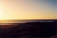 Sunset over the northern part of The Coorong, approaching the town of Meningie, South Australia.
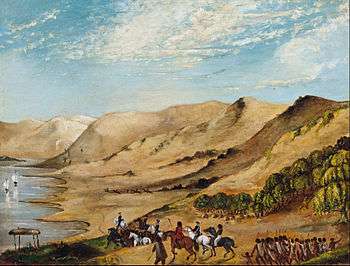 The punitive expedition to the Coorong after the massacre of survivors of the wreck of the Maria, August 1840.
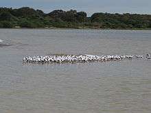 Flock of banded stilts on sand flats at the Coorong.
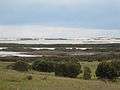 View of the Coorong and Younghusband Peninsula.
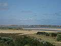 Entrance to The Coorong (mid-distance) looking from Hindmarsh Island
See also
References
- 1 2 Walsh, Frank (9 November 1967). "NATIONAL PARKS ACT, 1966: VARIOUS NATIONAL PARKS NAMED" (PDF). South Australian Government Gazette. South Australian Government. p. 2043. Retrieved 17 March 2018.
- ↑ "Protected Areas Information System Reserve List" (PDF). Government of South Australia. 9 March 2018. Retrieved 26 April 2018.
- ↑ "The Coorong, Lake Alexandrina & Albert Wetland". Ramsar Sites Information Service. Retrieved 25 April 2018.
- ↑ Map of the Coorong Accessed 3/3/7
- ↑ Coorong National Park – Things to see and do, Accessed 30/7/9
- ↑ Coorong National Park – Natural Attractions, Accessed 30/7/9
- ↑ "No. 56 of 1972 (National Parks and Wildlife Act, 1972)". The South Australian Government Gazette. Government of South Australia: 700. 27 April 1972. Retrieved 20 January 2017.
- ↑ "NATIONAL PARKS AND WILDLIFE ACT 1972 PART HI: RECONSTITUTION OF THE COORONG GAME RESERVE AS PART OF THE COORONG NATIONAL PARK" (PDF). The South Australian Government Gazette. Government of South Australia: 170. 14 January 1993. Retrieved 7 January 2018.
- ↑ Rudduck, Penny (May 1982). "EUROPEAN HERITAGE OF THE COORONG, A general survey of the sites of Early European Heritage of the area now comprising the Coorong National Park and Coorong Game Reserve" (PDF). National Parks and Wildlife Service, Government of South Australia. Retrieved 6 January 2018.
- ↑ "Important Bird Areas factsheet: Coorong". BirdLife International. 2016. Retrieved 3 December 2016.
- ↑ Shipwreck lifeboat washes up in Australia, ABC News Online, 6 February 2013
External links
![]()