Cape Jaffa, South Australia
| Cape Jaffa South Australia | |||||||||||||||
|---|---|---|---|---|---|---|---|---|---|---|---|---|---|---|---|
.JPG) New marina at Cape Jaffa, South Australia | |||||||||||||||
 Cape Jaffa Location in South Australia | |||||||||||||||
| Coordinates | 36°57′12″S 139°40′24″E / 36.95333°S 139.67333°ECoordinates: 36°57′12″S 139°40′24″E / 36.95333°S 139.67333°E | ||||||||||||||
| Established | 1998[1] | ||||||||||||||
| Postcode(s) | 5275[2] | ||||||||||||||
| Time zone | ACST (UTC+9:30) | ||||||||||||||
| • Summer (DST) | ACST (UTC+10:30) | ||||||||||||||
| Location |
| ||||||||||||||
| LGA(s) | Kingston District Council[1] | ||||||||||||||
| State electorate(s) | MacKillop[3] | ||||||||||||||
| Federal Division(s) | Barker[4] | ||||||||||||||
| |||||||||||||||
| |||||||||||||||
| Footnotes |
Locations[1][2] Climatic data[5] Adjoining Localities[1] | ||||||||||||||
Cape Jaffa is a locality in the Australian state of South Australia located on the headland of Cape Jaffa on the state's south east coastline overlooking the body of water known in Australia as the Southern Ocean and by international authorities as the Great Australian Bight. It located about 19 kilometres (12 miles) south west of the town centre of Kingston SE and about 245 kilometres (152 miles) south south-east of the Adelaide city centre.[1][2][6][7]
The locality includes a settlement located on the north side of the headland overlooking Lacepede Bay which is also known as Cape Jaffa. The settlement includes a jetty and a marina. The locality includes part of the Bernouilli Conservation Reserve.[1][2][8][9][10][11] The Marina (known as Cape Jaffa Anchorage) received development approval in January 2006.[12] The plans allow for several stages of development. At least the first stage exists,[13] and the marina is considered to still be "under construction" in 2018.[14]
Cape Jaffa is located within the federal division of Barker, the state MacKillop and the local government area of the Kingston District Council.[1][3][4]
Gallery
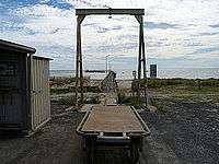 The Cape Jaffa jetty
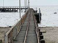 The Cape Jaffa jetty
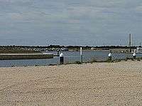 New marina at Cape Jaffa, South Australia
References
- 1 2 3 4 5 6 7 "Search result for " Cape Jaffa (LOCB)" (Record no SA0012214) with the following layers selected - "Suburbs and Localities", "Place names (gazetteer)" "Road Labels " and "Development Plan Layers"". Property Location Browser. Government of South Australia. Archived from the original on 12 October 2016. Retrieved 26 August 2016.
- 1 2 3 4 "Cape Jaffa, South Australia". Postcodes Australia. Retrieved 30 August 2016.
- 1 2 "District of MacKillop Background Profile". Electoral Commission SA. Retrieved 29 March 2016.
- 1 2 "Federal electoral division of Barker" (PDF). Australian Electoral Commission. Retrieved 28 March 2016.
- ↑ "Monthly climate statistics: Summary statistics Cape Jaffa (The Limestone) (nearest weather station)". Commonwealth of Australia , Bureau of Meteorology. Retrieved 30 August 2016.
- ↑ "Limits of Oceans and Seas, 3rd edition" (PDF) (PDF). International Hydrographic Organization. 1953. pp. 35–36. Retrieved 18 April 2016.
- ↑ "AHS – AA609582" (PDF) (PDF). The Australian Hydrographic Service. 5 July 2012. Retrieved 30 May 2013.
- ↑ "Development Plan, Kingston District Council Consolidated – 13 December 2012" (PDF). Department of Planning, Transport and Infrastructure. pp. 20, 107, 165 and 174. Archived from the original (PDF) on 18 December 2014. Retrieved 18 December 2014.
- ↑ "Cape Jaffa Code SSC40092 (SSC)". Australian Bureau of Statistics. Retrieved 15 November 2014.
- ↑ South Australia. Department of Marine and Harbors (1985), The Waters of South Australia a series of charts, sailing notes and coastal photographs, Dept. of Marine and Harbors, South Australia, pp. Chart 6, ISBN 978-0-7243-7603-2
- ↑ "Cape Jaffa Anchorage". The Australian Marinas Guide. Archived from the original on 26 January 2014. Retrieved 30 July 2014.
- ↑ Bruno Krumins, Governor's Deputy (12 January 2006). "DEVELOPMENT ACT 1993: SECTION 48 DECISION BY THE GOVERNOR'S DEPUTY" (PDF). South Australian Government Gazette. pp. 25–28. Retrieved 6 March 2018.
- ↑ Warner, Camilla (15 December 2017). "New $3 million dredge for Cape Jaffa". Coastal Leader. Retrieved 6 March 2018.
- ↑ "Cape Jaffa anchorage". Historical listing of proposals previously assessed. Department of Planning, Transport and Infrastructure. Retrieved 6 March 2018.