Columbiana, Ohio
| Columbiana, Ohio | |
|---|---|
| City | |
| City of Columbiana | |
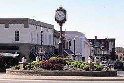 Downtown Columbiana | |
| Motto(s): "The City with the Small-Town Heart" | |
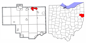 Location of Columbiana in Columbiana County and the State of Ohio | |
| Coordinates: 40°53′8″N 80°41′18″W / 40.88556°N 80.68833°WCoordinates: 40°53′8″N 80°41′18″W / 40.88556°N 80.68833°W | |
| Country | United States |
| State | Ohio |
| Counties | Columbiana, Mahoning |
| Government | |
| • Type | Council-Manager |
| • Mayor | Bryan Blakeman |
| • City Manager | Lance Willard |
| Area[1] | |
| • Total | 6.14 sq mi (15.90 km2) |
| • Land | 6.00 sq mi (15.54 km2) |
| • Water | 0.14 sq mi (0.36 km2) |
| Elevation[2] | 1,158 ft (353 m) |
| Population (2010)[3] | |
| • Total | 6,384 |
| • Estimate (2016[4]) | 6,257 |
| • Density | 1,064.0/sq mi (410.8/km2) |
| Time zone | UTC-5 (Eastern (EST)) |
| • Summer (DST) | UTC-4 (EDT) |
| ZIP code | 44408 |
| Area code(s) | 330, 234 |
| FIPS code | 39-17036[5] |
| GNIS feature ID | 1060989[2] |
| School District | Columbiana Exempted Village |
| Website |
www |
Columbiana is a city in Columbiana and Mahoning counties in the U.S. state of Ohio. The population was 6,384 at the 2010 census. The larger portion of the city, located in Columbiana County, is part of the Salem, OH Micropolitan Statistical Area, while the smaller Mahoning County portion is part of the Youngstown-Warren-Boardman, OH-PA Metropolitan Statistical Area.
The childhood home of notable inventor and businessman Harvey S. Firestone, Columbiana is considered to be one of the most livable cities in the Mahoning Valley. The city boasts one of the highest ranked school systems in Ohio[6], as well as many retail options, including a commercialized downtown area, a series of businesses located along Ohio Route 14, as well as Firestone Farms, a 1930s-themed outdoor business district.[7] Additionally, the city hosts the annual Shaker Woods Arts & Crafts Festival, which brings national attention to the city in the summer and fall seasons.[8]
History
Columbiana was laid out by Joshua Dixon and William Heald in 1805.[9] The city takes its name from Columbiana County, which itself is named in honor of Christopher Columbus, combining his surname with the suffix -iana.[10] Columbiana was incorporated as a village in 1837.[11] When founded, the village had a central location in Columbiana County; however, the formation of Mahoning County in 1846 caused it to run the border between the two new counties. The village officially became a city in 2000.
Geography
Columbiana is located at 40°53′8″N 80°41′18″W / 40.88556°N 80.68833°W (40.885579, -80.688327).[12]
The following highways pass through Columbiana:
According to the United States Census Bureau, the city has a total area of 6.14 square miles (15.90 km2), of which 6.00 square miles (15.54 km2) is land and 0.14 square miles (0.36 km2) is water.[1]
Demographics
| Historical population | |||
|---|---|---|---|
| Census | Pop. | %± | |
| 1860 | 1,174 | — | |
| 1870 | 870 | −25.9% | |
| 1880 | 1,223 | 40.6% | |
| 1890 | 1,112 | −9.1% | |
| 1900 | 1,339 | 20.4% | |
| 1910 | 1,582 | 18.1% | |
| 1920 | 2,114 | 33.6% | |
| 1930 | 2,485 | 17.5% | |
| 1940 | 2,687 | 8.1% | |
| 1950 | 3,369 | 25.4% | |
| 1960 | 4,164 | 23.6% | |
| 1970 | 4,959 | 19.1% | |
| 1980 | 4,987 | 0.6% | |
| 1990 | 4,961 | −0.5% | |
| 2000 | 5,635 | 13.6% | |
| 2010 | 6,384 | 13.3% | |
| Est. 2017 | 6,241 | [13] | −2.2% |
| Sources:[14][15][16][17][18][19][5][20] | |||
2010 census
As of the census[3] of 2010, there were 6,384 people, 2,881 households, and 1,763 families residing in the city. The population density was 1,064.0 inhabitants per square mile (410.8/km2). There were 3,181 housing units at an average density of 530.2 per square mile (204.7/km2). The racial makeup of the city was 97.7% White, 0.6% African American, 0.5% Asian, 0.4% from other races, and 0.8% from two or more races. Hispanic or Latino people of any race were 1.0% of the population.
There were 2,881 households of which 21.6% had children under the age of 18 living with them, 49.3% were married couples living together, 8.5% had a female householder with no husband present, 3.4% had a male householder with no wife present, and 38.8% were non-families. 34.5% of all households were made up of individuals and 18.4% had someone living alone who was 65 years of age or older. The average household size was 2.15 and the average family size was 2.74.
The median age in the city was 49.4 years. 17.5% of residents were under the age of 18; 7.6% were between the ages of 18 and 24; 19.9% were from 25 to 44; 27.7% were from 45 to 64; and 27.4% were 65 years of age or older. The gender makeup of the city was 46.6% male and 53.4% female.
2000 census
As of the census[5] of 2000, there were 5,635 people, 2,534 households, and 1,576 families residing in the city. The population density was 930.4 people per square mile (359.0/km²). There were 2,707 housing units at an average density of 446.9 per square mile (172.5/km²). The racial makeup of the city was 98.86% White, 0.11% African American, 0.07% Native American, 0.18% Asian, 0.02% Pacific Islander, 0.07% from other races, and 0.69% from two or more races. Hispanic or Latino people of any race were 0.32% of the population.
There were 2,534 households out of which 22.2% had children under the age of 18 living with them, 51.8% were married couples living together, 7.5% had a female householder with no husband present, and 37.8% were non-families. 34.9% of all households were made up of individuals and 17.7% had someone living alone who was 65 years of age or older. The average household size was 2.15 and the average family size was 2.76.
In the city the population was spread out with 19.0% under the age of 18, 6.8% from 18 to 24, 23.5% from 25 to 44, 25.3% from 45 to 64, and 25.3% who were 65 years of age or older. The median age was 46 years. For every 100 females, there were 87.3 males. For every 100 females age 18 and over, there were 82.1 males.
The median income for a household in the city was $34,560, and the median income for a family was $42,363. Males had a median income of $33,693 versus $21,648 for females. The per capita income for the city was $19,727. About 4.9% of families and 6.5% of the population were below the poverty line, including 7.8% of those under age 18 and 6.1% of those age 65 or over.
Education
Children in Columbiana are served by the Columbiana Exempted Village School District. The current schools in the district are:
- Joshua Dixon Elementary School – 333 N Middle Street, grades K-4
- South Side Middle School – 720 Columbiana-Waterford Road, grades 5-8
- Columbiana High School – 700 Columbiana-Waterford Road, grades 9-12
Some local children attend Heartland Christian School, which first opened for the 1996-1997 school year. The school's philosophy is based on the Bible.[21]
The city contains a public library.[22]
Arts and culture

Throughout the year, many events are hosted in the city. The Columbiana Street Fair, a civic festival hosted by the American Legion, is held on the Thursday through Saturday following Labor Day. Columbiana also hosts the Harvey S. Firestone Festival of the Arts on the first Saturday in August, and the Shaker Woods Festival on the second, third and fourth weekends of August. Columbiana also prides itself on its annual Community Celebration on the Fourth of July at Firestone Park.
Notable people
- Pete Allen – Major League Baseball catcher for the Cleveland Spiders, proctologist
- J. Warren Bettis – jurist
- Linda Bolon – Member of the Ohio House of Representatives from the 1st district
- Harvey Firestone – businessman & founder of the Firestone Tire and Rubber Company
- Jacob Hostetter – U.S. Representative from Pennsylvania's 4th District
- Craig Newbold – Member of the Ohio House of Representatives from the 1st district
- John D. Shivers Jr. – Member of the Ohio House of Representatives from the 3rd district
- Paul Stamets – mycologist
- Clarence Wetzel – Member of the Ohio House of Representatives from the 34th district
- Jason Wilson – Member of the Ohio Senate from the 30th district
References
- 1 2 "US Gazetteer files 2010". United States Census Bureau. Archived from the original on 2012-07-14. Retrieved 2013-01-06.
- 1 2 "US Board on Geographic Names". United States Geological Survey. 2007-10-25. Retrieved 2008-01-31.
- 1 2 "American FactFinder". United States Census Bureau. Retrieved 2013-01-06.
- ↑ "Population and Housing Unit Estimates". Retrieved June 9, 2017.
- 1 2 3 "American FactFinder". United States Census Bureau. Archived from the original on 2013-09-11. Retrieved 2008-01-31.
- ↑ U.S. News & World Report. "Columbiana High School". Retrieved 2017-04-21.
- ↑ Firestone Farms. "Firestone Farms". Retrieved 2018-06-26.
- ↑ City of Columbiana. "City of Columbiana History". Retrieved 2018-06-26.
- ↑ McCord, William B. (1905). History of Columbiana County, Ohio and Representative Citizens. Biographical Publishing Company. p. 277.
- ↑ Overman, William Daniel (1958). Ohio Town Names. Akron, OH: Atlantic Press. p. 32.
- ↑ Mack, Horace (1879). History of Columbiana County, Ohio: With Illustrations and Biographical Sketches of Some of Its Prominent Men and Pioneers. Unigraphic. p. 144.
- ↑ "US Gazetteer files: 2010, 2000, and 1990". United States Census Bureau. 2011-02-12. Retrieved 2011-04-23.
- ↑ "Population and Housing Unit Estimates". Retrieved May 26, 2018.
- ↑ "Population of Civil Divisions Less than Counties" (PDF). Statistics of the Population of the United States at the Tenth Census. U.S. Census Bureau. Retrieved 28 November 2013.
- ↑ "Population of Civil Divisions Less than Counties" (PDF). Statistics of the Population of the United States at the Tenth Census. U.S. Census Bureau. Retrieved 28 November 2013.
- ↑ "Population: Ohio" (PDF). 1910 U.S. Census. U.S. Census Bureau. Retrieved 28 November 2013.
- ↑ "Population: Ohio" (PDF). 1930 US Census. U.S. Census Bureau. Retrieved 28 November 2013.
- ↑ "Number of Inhabitants: Ohio" (PDF). 18th Census of the United States. U.S. Census Bureau. Retrieved 22 November 2013.
- ↑ "Ohio: Population and Housing Unit Counts" (PDF). U.S. Census Bureau. Retrieved 22 November 2013.
- ↑ "Incorporated Places and Minor Civil Divisions Datasets: Subcounty Population Estimates: April 1, 2010 to July 1, 2012". U.S. Census Bureau. Archived from the original on 17 June 2013. Retrieved 25 November 2013.
- ↑ About Us Archived 2008-01-31 at the Wayback Machine., Heartland Christian School, 2006. Accessed 2007-09-10.
- ↑ "Homepage". Columbiana Public Library. Retrieved 25 February 2018.
Municipalities and communities of Columbiana County, Ohio, United States | ||
|---|---|---|
| Cities |  | |
| Villages | ||
| Townships | ||
| CDPs | ||
| Unincorporated communities |
| |
| Ghost town | ||
| Footnotes | ‡This populated place also has portions in an adjacent county or counties | |
Municipalities and communities of Mahoning County, Ohio, United States | ||
|---|---|---|
| Cities |  | |
| Villages | ||
| Townships | ||
| CDPs | ||
| Unincorporated communities |
| |
| Footnotes | ‡This populated place also has portions in an adjacent county or counties | |