Damascus, Ohio
| Damascus, Ohio | |
|---|---|
| Census-designated place | |
 Damascus Grade School | |
 Location of Damascus, Ohio | |
| Coordinates: 40°54′4″N 80°57′18″W / 40.90111°N 80.95500°WCoordinates: 40°54′4″N 80°57′18″W / 40.90111°N 80.95500°W | |
| Country | United States |
| State | Ohio |
| Counties | Mahoning, Columbiana |
| Townships | Goshen, Butler |
| Area | |
| • Total | 0.81 sq mi (2.09 km2) |
| • Land | 0.80 sq mi (2.07 km2) |
| • Water | 0.008 sq mi (0.02 km2) |
| Elevation[1] | 1,115 ft (340 m) |
| Population (2010) | |
| • Total | 443 |
| • Density | 554/sq mi (214.0/km2) |
| Time zone | UTC-5 (Eastern (EST)) |
| • Summer (DST) | UTC-4 (EDT) |
| ZIP code | 44619 |
| Area code(s) | 330, 234 |
| FIPS code | 39-20030 |
| GNIS code | 1064504 |
| School District | West Branch Local |
Damascus is a census-designated place (CDP) in southwestern Goshen Township in Mahoning County and northwestern Butler Township in Columbiana County in the U.S. state of Ohio.[2][3] As of the 2010 census, it had a population of 443.[4] Damascus has a post office, with the ZIP code of 44619.[5] The Mahoning County portion of Damascus is part of the Youngstown-Warren-Boardman, OH-PA Metropolitan Statistical Area, while the Columbiana County portion is part of the Salem, OH Micropolitan Statistical Area.
The community lies at the intersection of U.S. Route 62 and State Routes 173 and 534.[6]
History
Damascus was platted in 1808.[7] The community derives its name from the ancient city of Damascus, in Syria.[8] Damascus was originally built up chiefly by Quakers.[9]
The Damascus post office opened in 1828.[10]
References
- ↑ "US Board on Geographic Names". United States Geological Survey. 2007-10-25. Retrieved 2008-01-31.
- ↑ DeLorme. Ohio Atlas & Gazetteer. 7th ed. Yarmouth: DeLorme, 2004, p. 52. ISBN 0-89933-281-1.
- ↑ U.S. Geological Survey Geographic Names Information System: Damascus, Ohio
- ↑ "Geographic Identifiers: 2010 Demographic Profile Data (G001): Damascus CDP, Ohio". U.S. Census Bureau, American Factfinder. Retrieved March 28, 2013.
- ↑ Zip Code Lookup
- ↑ DeLorme. Ohio Atlas & Gazetteer. 7th ed. Yarmouth: DeLorme, 2004, p. 34. ISBN 0-89933-281-1.
- ↑ Mack, Horace (1879). History of Columbiana County, Ohio: With Illustrations and Biographical Sketches of Some of Its Prominent Men and Pioneers. Unigraphic. p. 100.
- ↑ Overman, William Daniel (1958). Ohio Town Names. Akron, OH: Atlantic Press. p. 36.
- ↑ McCord, William B. (1905). History of Columbiana County, Ohio and Representative Citizens. Biographical Publishing Company. p. 267.
- ↑ Sanderson, Thomas W. (1907). Twentieth Century History of Youngstown and Mahoning County. Biographical Publishing Company. p. 204.
Municipalities and communities of Columbiana County, Ohio, United States | ||
|---|---|---|
| Cities | 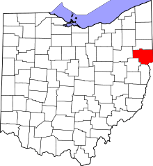 | |
| Villages | ||
| Townships | ||
| CDPs | ||
| Unincorporated communities |
| |
| Ghost town | ||
| Footnotes | ‡This populated place also has portions in an adjacent county or counties | |
Municipalities and communities of Mahoning County, Ohio, United States | ||
|---|---|---|
| Cities | 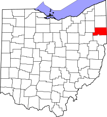 | |
| Villages | ||
| Townships | ||
| CDPs | ||
| Unincorporated communities |
| |
| Footnotes | ‡This populated place also has portions in an adjacent county or counties | |