Smith Township, Mahoning County, Ohio
| Smith Township, Mahoning County, Ohio | |
|---|---|
| Township | |
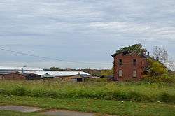 Abandoned buildings at the Alliance Clay Product Company complex | |
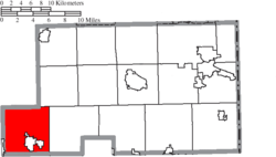 Location of Smith Township in Mahoning County | |
| Coordinates: 40°55′53″N 81°2′36″W / 40.93139°N 81.04333°WCoordinates: 40°55′53″N 81°2′36″W / 40.93139°N 81.04333°W | |
| Country | United States |
| State | Ohio |
| County | Mahoning |
| Area | |
| • Total | 32.5 sq mi (84.1 km2) |
| • Land | 31.8 sq mi (82.3 km2) |
| • Water | 0.7 sq mi (1.7 km2) |
| Elevation[1] | 1,079 ft (329 m) |
| Population (2010) | |
| • Total | 4,510 |
| • Density | 142/sq mi (54.8/km2) |
| Time zone | UTC-5 (Eastern (EST)) |
| • Summer (DST) | UTC-4 (EDT) |
| FIPS code | 39-72740[2] |
| GNIS feature ID | 1086570[1] |
Smith Township is one of the fourteen townships of Mahoning County, Ohio, United States. The 2010 census found 4,510 people in the township.[3]
Geography
Located in the southwestern corner of the county, it borders the following townships:
- Deerfield Township, Portage County - north
- Berlin Township - northeast
- Goshen Township - east
- Butler Township, Columbiana County - southeast corner
- Knox Township, Columbiana County - south
- Lexington Township, Stark County - west
The farthest west township in Mahoning County, it is the only township to border Stark County.
Several populated places are located in Smith Township:
- The city of Alliance, in the southwest corner
- The village of Beloit, in the southeast
- The village of Sebring, in the south
- The census-designated place of Maple Ridge, in the southwest
- The unincorporated community of North Benton, in the north
Name and history
Statewide, the only other Smith Township is located in Belmont County.
Smith Township was organized in March, 1821 upon the petition of Judge William Smith, in whose honor it was named. Judge William Smith was a pioneer in Mahoning County.[4]
For many years, the township was part of Columbiana County, before becoming part of Mahoning County in 1846.[5]
Government
The township is governed by a three-member board of trustees, who are elected in November of odd-numbered years to a four-year term beginning on the following January 1. Two are elected in the year after the presidential election and one is elected in the year before it. There is also an elected township fiscal officer,[6] who serves a four-year term beginning on April 1 of the year after the election, which is held in November of the year before the presidential election. Vacancies in the fiscal officership or on the board of trustees are filled by the remaining trustees.
References
- 1 2 "US Board on Geographic Names". United States Geological Survey. 2007-10-25. Retrieved 2008-01-31.
- ↑ "American FactFinder". United States Census Bureau. Retrieved 2008-01-31.
- ↑ "Geographic Identifiers: 2010 Demographic Profile Data (G001): Smith township, Mahoning County, Ohio". U.S. Census Bureau, American Factfinder. Retrieved March 27, 2013.
- ↑ Sanderson, Thomas W. (1907). Twentieth Century History of Youngstown and Mahoning County. Biographical Publishing Company. p. 226.
- ↑ Mack, Horace (1879). History of Columbiana County, Ohio: With Illustrations and Biographical Sketches of Some of Its Prominent Men and Pioneers. Unigraphic. p. 311.
- ↑ §503.24, §505.01, and §507.01 of the Ohio Revised Code. Accessed 4/30/2009.
External links
Municipalities and communities of Mahoning County, Ohio, United States | ||
|---|---|---|
| Cities | 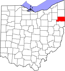 | |
| Villages | ||
| Townships | ||
| CDPs | ||
| Unincorporated communities |
| |
| Footnotes | ‡This populated place also has portions in an adjacent county or counties | |