Canfield Township, Mahoning County, Ohio
| Canfield Township, Mahoning County, Ohio | |
|---|---|
| Township | |
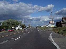 Suburban development on U.S. Route 224 | |
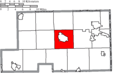 Location of Canfield Township in Mahoning County | |
| Coordinates: 41°2′0″N 80°45′14″W / 41.03333°N 80.75389°WCoordinates: 41°2′0″N 80°45′14″W / 41.03333°N 80.75389°W | |
| Country | United States |
| State | Ohio |
| County | Mahoning |
| Area | |
| • Total | 26.0 sq mi (67.3 km2) |
| • Land | 25.8 sq mi (66.7 km2) |
| • Water | 0.2 sq mi (0.6 km2) |
| Elevation[1] | 1,171 ft (357 m) |
| Population (2010) | |
| • Total | 16,164 |
| • Density | 628/sq mi (242.5/km2) |
| Time zone | UTC-5 (Eastern (EST)) |
| • Summer (DST) | UTC-4 (EDT) |
| ZIP code | 44406 |
| Area code(s) | 234/330 |
| FIPS code | 39-11374[2] |
| GNIS feature ID | 1086560[1] |
Canfield Township is one of the fourteen townships of Mahoning County, Ohio, United States. The 2010 census found 16,164 people in the township, 8,649 of whom lived in the unincorporated portions of the township.[3]
Geography
Located in the center of the county, it borders the following townships:
- Austintown Township - north
- Youngstown - northeast corner
- Boardman Township - east
- Beaver Township - southeast
- Green Township - southwest
- Ellsworth Township - west
- Jackson Township - northwest corner
The city of Canfield is located in central Canfield Township.
Name and history
Canfield Township is named for Judson Canfield, a pioneer settler and prominent land owner.[4]
It is the only Canfield Township statewide.
Government
The township is governed by a three-member board of trustees, who are elected in November of odd-numbered years to a four-year term beginning on the following January 1. Two are elected in the year after the presidential election and one is elected in the year before it. There is also an elected township fiscal officer,[5] who serves a four-year term beginning on April 1 of the year after the election, which is held in November of the year before the presidential election. Vacancies in the fiscal officership or on the board of trustees are filled by the remaining trustees.
References
- 1 2 "US Board on Geographic Names". United States Geological Survey. 2007-10-25. Retrieved 2008-01-31.
- ↑ "American FactFinder". United States Census Bureau. Archived from the original on 2013-09-11. Retrieved 2008-01-31.
- ↑ "Geographic Identifiers: 2010 Demographic Profile Data (G001): Canfield township, Mahoning County, Ohio". U.S. Census Bureau, American Factfinder. Retrieved March 27, 2013.
- ↑ Sanderson, Thomas W. (1907). Twentieth Century History of Youngstown and Mahoning County. Biographical Publishing Company. p. 182.
- ↑ §503.24, §505.01, and §507.01 of the Ohio Revised Code. Accessed 4/30/2009.
External links
Municipalities and communities of Mahoning County, Ohio, United States | ||
|---|---|---|
| Cities | 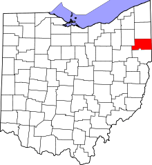 | |
| Villages | ||
| Townships | ||
| CDPs | ||
| Unincorporated communities |
| |
| Footnotes | ‡This populated place also has portions in an adjacent county or counties | |