Clion, Indre
| Clion | |
|---|---|
| Commune | |
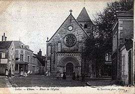 The Church of Sainte-Colombe in Clion, in 1900 | |
 Clion Location within Centre-Val de Loire region  Clion | |
| Coordinates: 46°56′32″N 1°14′00″E / 46.9422°N 1.2333°ECoordinates: 46°56′32″N 1°14′00″E / 46.9422°N 1.2333°E | |
| Country | France |
| Region | Centre-Val de Loire |
| Department | Indre |
| Arrondissement | Châteauroux |
| Canton | Buzançais |
| Government | |
| • Mayor (2008–2014) | Williams Lauerière |
| Area1 | 33.53 km2 (12.95 sq mi) |
| Population (2009)2 | 1,123 |
| • Density | 33/km2 (87/sq mi) |
| Time zone | UTC+1 (CET) |
| • Summer (DST) | UTC+2 (CEST) |
| INSEE/Postal code | 36055 /36700 |
| Elevation |
86–153 m (282–502 ft) (avg. 108 m or 354 ft) |
|
1 French Land Register data, which excludes lakes, ponds, glaciers > 1 km2 (0.386 sq mi or 247 acres) and river estuaries. 2 Population without double counting: residents of multiple communes (e.g., students and military personnel) only counted once. | |
Clion is a commune in the Indre department in central France.
It is situated 38 km or 24 miles northwest of Châteauroux, the nearest large city. The Indre and Ozance rivers flow through the commune.
Population
| Historical population | ||
|---|---|---|
| Year | Pop. | ±% |
| 1793 | 1,191 | — |
| 1800 | 1,035 | −13.1% |
| 1806 | 1,340 | +29.5% |
| 1821 | 1,481 | +10.5% |
| 1831 | 1,482 | +0.1% |
| 1836 | 1,602 | +8.1% |
| 1841 | 1,651 | +3.1% |
| 1846 | 1,713 | +3.8% |
| 1851 | 1,789 | +4.4% |
| 1856 | 1,867 | +4.4% |
| 1861 | 1,854 | −0.7% |
| 1866 | 1,940 | +4.6% |
| 1872 | 1,907 | −1.7% |
| 1876 | 1,913 | +0.3% |
| 1881 | 1,953 | +2.1% |
| 1886 | 1,986 | +1.7% |
| 1891 | 1,917 | −3.5% |
| 1896 | 1,968 | +2.7% |
| 1901 | 1,915 | −2.7% |
| 1906 | 1,973 | +3.0% |
| 1911 | 1,957 | −0.8% |
| 1921 | 1,804 | −7.8% |
| 1926 | 1,694 | −6.1% |
| 1931 | 1,649 | −2.7% |
| 1936 | 1,670 | +1.3% |
| 1946 | 1,676 | +0.4% |
| 1954 | 1,749 | +4.4% |
| 1962 | 1,671 | −4.5% |
| 1968 | 1,561 | −6.6% |
| 1975 | 1,448 | −7.2% |
| 1982 | 1,387 | −4.2% |
| 1990 | 1,243 | −10.4% |
| 1999 | 1,155 | −7.1% |
| 2009 | 1,123 | −2.8% |
Residents are known as Clionnais.[1]
See also
References
- ↑ "Mairie de Clion, la Commune de Clion et son village (36700) (Indre)". Annuaire-Mairie. Retrieved 20 April 2018.
| Wikimedia Commons has media related to Clion (Indre). |
This article is issued from
Wikipedia.
The text is licensed under Creative Commons - Attribution - Sharealike.
Additional terms may apply for the media files.