Tranzault
| Tranzault | |
|---|---|
| Commune | |
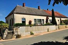 Town hall | |
 Tranzault Location within Centre-Val de Loire region  Tranzault | |
| Coordinates: 46°37′54″N 1°51′03″E / 46.6317°N 1.8508°ECoordinates: 46°37′54″N 1°51′03″E / 46.6317°N 1.8508°E | |
| Country | France |
| Region | Centre-Val de Loire |
| Department | Indre |
| Arrondissement | La Châtre |
| Canton | Neuvy-Saint-Sépulchre |
| Government | |
| • Mayor (2008–2014) | Christian Paguignon |
| Area1 | 17.97 km2 (6.94 sq mi) |
| Population (2009)2 | 322 |
| • Density | 18/km2 (46/sq mi) |
| Time zone | UTC+1 (CET) |
| • Summer (DST) | UTC+2 (CEST) |
| INSEE/Postal code | 36226 /36230 |
| Elevation |
166–238 m (545–781 ft) (avg. 228 m or 748 ft) |
|
1 French Land Register data, which excludes lakes, ponds, glaciers > 1 km2 (0.386 sq mi or 247 acres) and river estuaries. 2 Population without double counting: residents of multiple communes (e.g., students and military personnel) only counted once. | |
Tranzault is a commune in the Indre department in central France.
Geography
The commune is traversed by the river Bouzanne.
Population
| Historical population | ||
|---|---|---|
| Year | Pop. | ±% |
| 1793 | 600 | — |
| 1800 | 467 | −22.2% |
| 1806 | 485 | +3.9% |
| 1821 | 518 | +6.8% |
| 1831 | 521 | +0.6% |
| 1836 | 536 | +2.9% |
| 1841 | 525 | −2.1% |
| 1846 | 525 | +0.0% |
| 1851 | 496 | −5.5% |
| 1856 | 503 | +1.4% |
| 1861 | 548 | +8.9% |
| 1866 | 593 | +8.2% |
| 1872 | 612 | +3.2% |
| 1876 | 616 | +0.7% |
| 1881 | 633 | +2.8% |
| 1886 | 637 | +0.6% |
| 1891 | 667 | +4.7% |
| 1896 | 635 | −4.8% |
| 1901 | 648 | +2.0% |
| 1906 | 655 | +1.1% |
| 1911 | 616 | −6.0% |
| 1921 | 577 | −6.3% |
| 1926 | 539 | −6.6% |
| 1931 | 498 | −7.6% |
| 1936 | 495 | −0.6% |
| 1946 | 461 | −6.9% |
| 1954 | 420 | −8.9% |
| 1962 | 381 | −9.3% |
| 1968 | 364 | −4.5% |
| 1975 | 324 | −11.0% |
| 1982 | 318 | −1.9% |
| 1990 | 324 | +1.9% |
| 1999 | 323 | −0.3% |
| 2006 | 324 | +0.3% |
| 2009 | 322 | −0.6% |
See also
References
| Wikimedia Commons has media related to Tranzault. |
This article is issued from
Wikipedia.
The text is licensed under Creative Commons - Attribution - Sharealike.
Additional terms may apply for the media files.