La Buxerette
| La Buxerette | |
|---|---|
| Commune | |
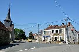 The church square in La Buxerette | |
 La Buxerette Location within Centre-Val de Loire region  La Buxerette | |
| Coordinates: 46°29′43″N 1°48′11″E / 46.4953°N 1.8031°ECoordinates: 46°29′43″N 1°48′11″E / 46.4953°N 1.8031°E | |
| Country | France |
| Region | Centre-Val de Loire |
| Department | Indre |
| Arrondissement | La Châtre |
| Canton | Neuvy-Saint-Sépulchre |
| Intercommunality | Marche berrichonne |
| Government | |
| • Mayor (2008–2014) | Michel Bretaud |
| Area1 | 10.99 km2 (4.24 sq mi) |
| Population (2009)2 | 108 |
| • Density | 9.8/km2 (25/sq mi) |
| Time zone | UTC+1 (CET) |
| • Summer (DST) | UTC+2 (CEST) |
| INSEE/Postal code | 36028 /36140 |
| Elevation |
282–387 m (925–1,270 ft) (avg. 372 m or 1,220 ft) |
|
1 French Land Register data, which excludes lakes, ponds, glaciers > 1 km2 (0.386 sq mi or 247 acres) and river estuaries. 2 Population without double counting: residents of multiple communes (e.g., students and military personnel) only counted once. | |
La Buxerette is a commune in the Indre department in central France.
Geography
The Bouzanne forms the commune's western border.
Population
| Historical population | ||
|---|---|---|
| Year | Pop. | ±% |
| 1793 | 168 | — |
| 1800 | 181 | +7.7% |
| 1806 | 287 | +58.6% |
| 1821 | 330 | +15.0% |
| 1831 | 317 | −3.9% |
| 1836 | 359 | +13.2% |
| 1841 | 351 | −2.2% |
| 1846 | 390 | +11.1% |
| 1851 | 386 | −1.0% |
| 1856 | 360 | −6.7% |
| 1861 | 367 | +1.9% |
| 1866 | 370 | +0.8% |
| 1872 | 373 | +0.8% |
| 1876 | 383 | +2.7% |
| 1881 | 411 | +7.3% |
| 1886 | 460 | +11.9% |
| 1891 | 450 | −2.2% |
| 1896 | 449 | −0.2% |
| 1901 | 459 | +2.2% |
| 1906 | 422 | −8.1% |
| 1911 | 436 | +3.3% |
| 1921 | 430 | −1.4% |
| 1926 | 413 | −4.0% |
| 1931 | 395 | −4.4% |
| 1936 | 386 | −2.3% |
| 1946 | 361 | −6.5% |
| 1954 | 314 | −13.0% |
| 1962 | 269 | −14.3% |
| 1968 | 270 | +0.4% |
| 1975 | 205 | −24.1% |
| 1982 | 183 | −10.7% |
| 1990 | 168 | −8.2% |
| 1999 | 128 | −23.8% |
| 2009 | 108 | −15.6% |
See also
References
| Wikimedia Commons has media related to La Buxerette. |
This article is issued from
Wikipedia.
The text is licensed under Creative Commons - Attribution - Sharealike.
Additional terms may apply for the media files.