Aize
| Aize | |
|---|---|
| Commune | |
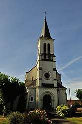 The church of Saint-Hilaire, in Aize | |
 Aize Location within Centre-Val de Loire region  Aize | |
| Coordinates: 47°06′17″N 1°42′09″E / 47.1047°N 1.7025°ECoordinates: 47°06′17″N 1°42′09″E / 47.1047°N 1.7025°E | |
| Country | France |
| Region | Centre-Val de Loire |
| Department | Indre |
| Arrondissement | Issoudun |
| Canton | Levroux |
| Intercommunality | Vatan |
| Government | |
| • Mayor (2014-2020) | Michel Chevallet |
| Area1 | 17.07 km2 (6.59 sq mi) |
| Population (2014)2 | 117 |
| • Density | 6.9/km2 (18/sq mi) |
| Time zone | UTC+1 (CET) |
| • Summer (DST) | UTC+2 (CEST) |
| INSEE/Postal code | 36002 /36150 |
| Elevation |
100–161 m (328–528 ft) (avg. 121 m or 397 ft) |
|
1 French Land Register data, which excludes lakes, ponds, glaciers > 1 km2 (0.386 sq mi or 247 acres) and river estuaries. 2 Population without double counting: residents of multiple communes (e.g., students and military personnel) only counted once. | |
Aize is a commune in the Indre department in central France.
Population
| Historical population | ||
|---|---|---|
| Year | Pop. | ±% |
| 1793 | 463 | — |
| 1800 | 446 | −3.7% |
| 1806 | 430 | −3.6% |
| 1821 | 449 | +4.4% |
| 1831 | 466 | +3.8% |
| 1836 | 472 | +1.3% |
| 1841 | 439 | −7.0% |
| 1846 | 494 | +12.5% |
| 1851 | 506 | +2.4% |
| 1856 | 503 | −0.6% |
| 1861 | 501 | −0.4% |
| 1866 | 494 | −1.4% |
| 1872 | 481 | −2.6% |
| 1876 | 452 | −6.0% |
| 1881 | 431 | −4.6% |
| 1886 | 452 | +4.9% |
| 1891 | 462 | +2.2% |
| 1896 | 480 | +3.9% |
| 1901 | 457 | −4.8% |
| 1906 | 452 | −1.1% |
| 1911 | 432 | −4.4% |
| 1921 | 382 | −11.6% |
| 1926 | 378 | −1.0% |
| 1931 | 362 | −4.2% |
| 1936 | 350 | −3.3% |
| 1946 | 330 | −5.7% |
| 1954 | 277 | −16.1% |
| 1962 | 243 | −12.3% |
| 1968 | 200 | −17.7% |
| 1975 | 169 | −15.5% |
| 1982 | 164 | −3.0% |
| 1990 | 131 | −20.1% |
| 1999 | 126 | −3.8% |
| 2009 | 130 | +3.2% |
See also
References
| Wikimedia Commons has media related to Aize. |
This article is issued from
Wikipedia.
The text is licensed under Creative Commons - Attribution - Sharealike.
Additional terms may apply for the media files.