Orsennes
| Orsennes | |
|---|---|
| Commune | |
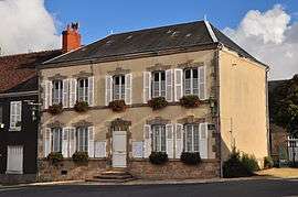 The town hall in Orsennes | |
 Orsennes Location within Centre-Val de Loire region  Orsennes | |
| Coordinates: 46°28′37″N 1°41′01″E / 46.4769°N 1.6836°ECoordinates: 46°28′37″N 1°41′01″E / 46.4769°N 1.6836°E | |
| Country | France |
| Region | Centre-Val de Loire |
| Department | Indre |
| Arrondissement | La Châtre |
| Canton | Neuvy-Saint-Sépulchre |
| Government | |
| • Mayor (2008–2014) | Hervé Grandhomme |
| Area1 | 49.28 km2 (19.03 sq mi) |
| Population (2009)2 | 801 |
| • Density | 16/km2 (42/sq mi) |
| Time zone | UTC+1 (CET) |
| • Summer (DST) | UTC+2 (CEST) |
| INSEE/Postal code | 36146 /36190 |
| Elevation |
209–376 m (686–1,234 ft) (avg. 289 m or 948 ft) |
|
1 French Land Register data, which excludes lakes, ponds, glaciers > 1 km2 (0.386 sq mi or 247 acres) and river estuaries. 2 Population without double counting: residents of multiple communes (e.g., students and military personnel) only counted once. | |
Orsennes is a town and commune in the Indre department in central France.
Population
| Historical population | ||
|---|---|---|
| Year | Pop. | ±% |
| 1793 | 1,609 | — |
| 1800 | 1,287 | −20.0% |
| 1806 | 1,350 | +4.9% |
| 1821 | 1,417 | +5.0% |
| 1831 | 1,702 | +20.1% |
| 1836 | 1,744 | +2.5% |
| 1841 | 1,664 | −4.6% |
| 1846 | 1,845 | +10.9% |
| 1851 | 1,854 | +0.5% |
| 1856 | 1,895 | +2.2% |
| 1861 | 1,823 | −3.8% |
| 1866 | 1,890 | +3.7% |
| 1872 | 1,915 | +1.3% |
| 1876 | 2,028 | +5.9% |
| 1881 | 2,136 | +5.3% |
| 1886 | 2,255 | +5.6% |
| 1891 | 2,295 | +1.8% |
| 1896 | 2,302 | +0.3% |
| 1901 | 2,218 | −3.6% |
| 1906 | 2,268 | +2.3% |
| 1911 | 2,377 | +4.8% |
| 1921 | 2,014 | −15.3% |
| 1926 | 2,039 | +1.2% |
| 1931 | 1,964 | −3.7% |
| 1936 | 1,902 | −3.2% |
| 1946 | 1,632 | −14.2% |
| 1954 | 1,520 | −6.9% |
| 1962 | 1,446 | −4.9% |
| 1968 | 1,372 | −5.1% |
| 1975 | 1,185 | −13.6% |
| 1982 | 1,015 | −14.3% |
| 1990 | 913 | −10.0% |
| 1999 | 790 | −13.5% |
| 2009 | 801 | +1.4% |
See also
References
| Wikimedia Commons has media related to Orsennes. |
This article is issued from
Wikipedia.
The text is licensed under Creative Commons - Attribution - Sharealike.
Additional terms may apply for the media files.