Chautauqua, New York
| Chautauqua, New York | |
|---|---|
| Town | |
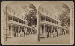 View of Simpson Avenue | |
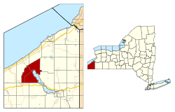 Location within Chautauqua County and New York | |
 Chautauqua Location within the state of New York | |
| Coordinates: 42°13′34″N 79°29′2″W / 42.22611°N 79.48389°W | |
| Country | United States |
| State | New York |
| County | Chautauqua |
| Government | |
| • Type | Town Council |
| • Town Supervisor | Donald D. Emhardt (D) |
| • Town Council |
Members' List
|
| Area[1] | |
| • Total | 67.19 sq mi (174.03 km2) |
| • Land | 67.10 sq mi (173.79 km2) |
| • Water | 0.09 sq mi (0.24 km2) |
| Elevation | 1,342 ft (409 m) |
| Population (2010) | |
| • Total | 4,464 |
| • Estimate (2016)[2] | 4,324 |
| • Density | 64.44/sq mi (24.88/km2) |
| Time zone | UTC-5 (Eastern (EST)) |
| • Summer (DST) | UTC-4 (EDT) |
| ZIP code | 14722 |
| Area code(s) | 716 |
| FIPS code | 36-013-14069 |
| GNIS feature ID | 0978815 |
| Website |
townofchautauqua |
Chautauqua is a town and lake resort community in Chautauqua County, New York, United States.[3] The population was 4,464 at the 2010 census.[4] The town is named after Chautauqua Lake. The traditional meaning remains "bag tied in the middle". The suggested meanings of this Seneca word have become numerous: "the place where one is lost"; "the place of easy death"; "fish taken out"; "foggy place"; "high up"; "two moccasins fastened together"; and "a bag tied in the middle".
The town of Chautauqua is in the western part of the county on the northwestern end of Chautauqua Lake. It is northwest of Jamestown. Chautauqua is famous as the home of the Chautauqua Institution, the birthplace in 1875 of the Chautauqua Movement of educational and cultural centers.
History
The town of Chautauqua was formed on April 11, 1805, from the town of Batavia, while still part of Genesee County. The first settler arrived the year before, near the current village of Mayville. When Chautauqua County was created on March 11, 1808, the town's territory was increased to include the eastern tier of townships, so that the town and the new county were coextensive. The town is the "mother of towns" in Chautauqua County since all other towns in the county towns were once part of it. The town is still one of the largest in the county.[5]
The Lewis Miller Cottage of the Chautauqua Institution was listed on the National Register of Historic Places and as a National Historic Landmark in 1966.[6] The Chautauqua Institution Historic District was listed in 1974.[6]
Geography
According to the United States Census Bureau, the town has a total area of 67.2 square miles (174.0 km2), of which 67.1 square miles (173.8 km2) of it is land and 0.077 square miles (0.2 km2), or 0.14%, is water.[4]
Surrounding towns
Demographics
| Historical population | |||
|---|---|---|---|
| Census | Pop. | %± | |
| 1820 | 2,518 | — | |
| 1830 | 2,432 | −3.4% | |
| 1840 | 2,980 | 22.5% | |
| 1850 | 2,622 | −12.0% | |
| 1860 | 2,837 | 8.2% | |
| 1870 | 3,064 | 8.0% | |
| 1880 | 3,570 | 16.5% | |
| 1890 | 3,259 | −8.7% | |
| 1900 | 3,590 | 10.2% | |
| 1910 | 3,515 | −2.1% | |
| 1920 | 3,533 | 0.5% | |
| 1930 | 3,802 | 7.6% | |
| 1940 | 3,819 | 0.4% | |
| 1950 | 4,222 | 10.6% | |
| 1960 | 4,376 | 3.6% | |
| 1970 | 4,341 | −0.8% | |
| 1980 | 4,728 | 8.9% | |
| 1990 | 4,554 | −3.7% | |
| 2000 | 4,666 | 2.5% | |
| 2010 | 4,464 | −4.3% | |
| Est. 2016 | 4,324 | [2] | −3.1% |
| U.S. Decennial Census[7] | |||
As of the census[8] of 2000, there were 4,666 people, 1,881 households, and 1,269 families residing in the town. The population density was 69.4 people per square mile (26.8/km²). There were 4,174 housing units at an average density of 62.1 per square mile (24.0/km²). The racial makeup of the town was 96.25% White, 1.59% African American, 0.24% Native American, 0.39% Asian, 0.09% Pacific Islander, 0.19% from other races, and 1.26% from two or more races. Hispanic or Latino of any race were 1.05% of the population.
There were 1,881 households out of which 27.1% had children under the age of 18 living with them, 56.7% were married couples living together, 7.0% had a female householder with no husband present, and 32.5% were non-families. 28.3% of all households were made up of individuals and 12.8% had someone living alone who was 65 years of age or older. The average household size was 2.35 and the average family size was 2.87.
In the town, the population was spread out with 22.4% under the age of 18, 7.3% from 18 to 24, 25.4% from 25 to 44, 26.9% from 45 to 64, and 18.0% who were 65 years of age or older. The median age was 41 years. For every 100 females, there were 105.2 males. For every 100 females age 18 and over, there were 104.2 males.
The median income for a household in the town was $36,379, and the median income for a family was $41,923. Males had a median income of $30,767 versus $23,561 for females. The per capita income for the town was $19,003. About 7.5% of families and 12.0% of the population were below the poverty line, including 17.3% of those under age 18 and 5.3% of those age 65 or over.
Transportation
New York State Route 394 and New York State Route 430, which intersect in Mayville, are the two primary roads in the town. Route 394 comes from Jamestown on the western side of the lake and continues on to Westfield. Route 430 comes from Jamestown on the eastern side of the lake and goes southwest from Mayville to the state line west of Findley Lake, where it becomes Pennsylvania Route 430.
Notable people
- Arthur Bestor, historian, public education critic
- John Jachym, businessman, philanthropist, sportsman
- Michael John LaChiusa, musical theater composer
- Hiram Lawton Richmond, former US Congressman from Pennsylvania
- Garnet Sixsmith, one of the first professional ice hockey players
- Gar Samuelson, original drummer of Megadeth (classic line-up)
- Heidi VanDerveer, women's basketball coach
Places in the town
- Chautauqua – The hamlet (and census-designated place) of Chautauqua, located on the west shore of Chautauqua Lake and location of the Chautauqua Institution on Route 394.
- Chautauqua Creek – A stream forming most of the town's boundary with Westfield.
- Chautauqua Post Office – USPS facility located on Bestor Plaza inside the gates of Chautauqua Institution.
- Cottage Park – A lakeside hamlet south of Mayville on Route 394.
- Dart Airfield (D79) – A grass runway airfield east of Mayville.
- Dean – A hamlet in the northeast corner of the town on County Road 37.
- Dewittville – A lakeside hamlet on the east side of the lake on County Road 52.
- Dewittville Bay – A bay near Point Chautauqua.
- Hartfield – A hamlet in the northeast part of the town.
- Hartfield Bay – A bay at the north end of Chautauqua Lake.
- Irwins Bay – A small bay between Lighthouse Point and Wahmeda.
- Lakeside Park – A small lakeside community south of Mayville.
- Lighthouse Point – A hamlet at a projection into the lake south of Mayville on Route 394.
- Magnolia – A lakeside hamlet in the southeast corner of the town on Chautauqua Lake on Route 394.
- Mayville – The village of Mayville is the county seat and is located on the northern end of Chautauqua Lake.
- Orchard Terrace – A lakeside community south of Chautauqua on Route 394.
- Pleasantville – A hamlet near the east town line on County Road 54.
- Point Chautauqua – A hamlet on a peninsula on the eastern side of the lake.
- Point Pleasant – A projection into Chautauqua Lake south of Mayville.
- Prendergast Point – A projection into Lake Chautauqua in the southeast corner of the town.
- Shorelands – A hamlet on the east side of Chautauqua Lake, east of Mayville on Route 490.
- Summerdale – A hamlet in the western part of the town on NY Route 430.
- Wahmeda – A lakeside hamlet north of Chautauqua on Route 394.
- Wooglin – A lakeside hamlet on the east side of the lake on Route 430.
See also
References
- ↑ "2016 U.S. Gazetteer Files". United States Census Bureau. Retrieved Jul 4, 2017.
- 1 2 "Population and Housing Unit Estimates". Retrieved June 9, 2017.
- ↑

- 1 2 "Geographic Identifiers: 2010 Demographic Profile Data (G001): Chautauqua town, Chautauqua County, New York". U.S. Census Bureau, American Factfinder. Retrieved November 5, 2014.
- ↑ History of Chautauqua, NY
- 1 2 National Park Service (2009-03-13). "National Register Information System". National Register of Historic Places. National Park Service.
- ↑ "Census of Population and Housing". Census.gov. Archived from the original on May 12, 2015. Retrieved June 4, 2015.
- ↑ "American FactFinder". United States Census Bureau. Archived from the original on 2013-09-11. Retrieved 2008-01-31.
External links
Municipalities and communities of Chautauqua County, New York, United States | ||
|---|---|---|
| Cities | 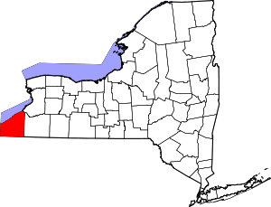 | |
| Towns | ||
| Villages | ||
| CDPs | ||
| Other hamlets | ||
| Indian reservation | ||
Coordinates: 42°12′35″N 79°28′00″W / 42.20972°N 79.46667°W