Paars
| Paars | |
|---|---|
| Commune | |
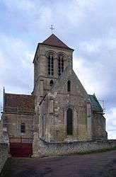 The church of Paars | |
 Paars Location within Hauts-de-France region  Paars | |
| Coordinates: 49°19′45″N 3°36′05″E / 49.3292°N 3.6014°ECoordinates: 49°19′45″N 3°36′05″E / 49.3292°N 3.6014°E | |
| Country | France |
| Region | Hauts-de-France |
| Department | Aisne |
| Arrondissement | Soissons |
| Canton | Fère-en-Tardenois |
| Intercommunality | Val de l'Aisne |
| Government | |
| • Mayor (2008–2014) | Jean Cesvet |
| Area1 | 5.15 km2 (1.99 sq mi) |
| Population (2012)2 | 297 |
| • Density | 58/km2 (150/sq mi) |
| Time zone | UTC+1 (CET) |
| • Summer (DST) | UTC+2 (CEST) |
| INSEE/Postal code | 02581 /02220 |
| Elevation |
54–169 m (177–554 ft) (avg. 90 m or 300 ft) |
|
1 French Land Register data, which excludes lakes, ponds, glaciers > 1 km2 (0.386 sq mi or 247 acres) and river estuaries. 2 Population without double counting: residents of multiple communes (e.g., students and military personnel) only counted once. | |
Paars is a commune in the Aisne department in Hauts-de-France in northern France.
Population
| Historical population | ||
|---|---|---|
| Year | Pop. | ±% |
| 1962 | 211 | — |
| 1968 | 225 | +6.6% |
| 1975 | 213 | −5.3% |
| 1982 | 192 | −9.9% |
| 1990 | 180 | −6.2% |
| 1999 | 210 | +16.7% |
| 2008 | 263 | +25.2% |
| 2012 | 297 | +12.9% |
See also
References
| Wikimedia Commons has media related to Paars. |
This article is issued from
Wikipedia.
The text is licensed under Creative Commons - Attribution - Sharealike.
Additional terms may apply for the media files.