Assateague State Park
| Assateague State Park | |
| Maryland State Park | |
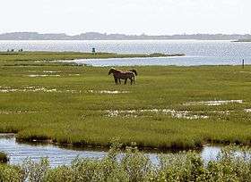 Feral horses in Assateague State Park | |
| Country | United States |
|---|---|
| State | Maryland |
| County | Worcester |
| Elevation | 0 ft (0 m) [1] |
| Coordinates | 38°13′45″N 75°08′37″W / 38.22917°N 75.14361°WCoordinates: 38°13′45″N 75°08′37″W / 38.22917°N 75.14361°W [1] |
| Area | 855 acres (346 ha) [2] |
| Established | 1956 |
| Management | Maryland Department of Natural Resources |
| IUCN category | V - Protected Landscape/Seascape |
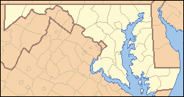 Location in Maryland | |
| Website: Assateague State Park | |
Assateague State Park is a public recreation area in Worcester County, Maryland, USA,, located at the north end of Assateague Island, a barrier island bordered by the Atlantic Ocean on the east and Sinepuxent Bay on the west. The state park is bordered on both its north and south sides by Assateague Island National Seashore and is reached via the Verrazano Bridge which carries Maryland Route 611 across Sinepuxent Bay. The park offers wildlife viewing, beach activities, and camping facilities. It is managed by the Maryland Park Service of the larger Maryland Department of Natural Resources with the support of volunteers working under the auspices of the non-profit Friends of Assateague State Park.[3][4]
History
State planners suggested establishing a state park on Assateague Island in 1940 and again in 1952. The park was finally created in 1956 when the state Board of Public Works accepted a gift of 540 acres from North Ocean Beach, Incorporated. Funds for further acquisitions were allocated by the General Assembly of Maryland in 1959 and 1962, with funding for facility development allocated in 1965.[5]
A tradition of New Year's Day walks in the park began on January 1, 1970.[6] It was started by two women who sought to celebrate the beauty of the island and rally against plans to develop areas around it.[6] It subsequently became an annual tradition, with the 30th iteration taking place in 2010,[7] and became very popular over time, with people driving from various other parts of the state to join in with up to 300 others.[8] The Ilia Fehrer / Judy Johnson Memorial Beach Walk, named after the two women who started it, is now part of Maryland's roster of the nationwide offering of First Day Hikes in state parks.[6]
Wildlife
Wildlife found in the park's marsh areas include deer, waterfowl, and feral horses.
Activities and amenities
Rackliffe House, which overlooks Sinepuxent Bay, is a restored 18th-century coastal plantation building that houses the Coastal Maryland Heritage Center. The park campground has 350 sites.[3]
See also
References
- 1 2 "Assateague State Park". Geographic Names Information System. United States Geological Survey.
- ↑ "Fiscal Year 2016 DNR Owned Lands Acreage" (PDF). Maryland Department of Natural Resources. September 29, 2016. Retrieved November 1, 2017.
- 1 2 "Assateague State Park". Maryland Department of Natural Resources. Retrieved February 8, 2016.
- ↑ "Friends of Assateague State Park". Maryland Department of Natural Resources. Retrieved February 8, 2016.
- ↑ Preferred Planning Alternative for Assateague Island Comprehensive Plan (Report). NPS Fish and Wildlife Service/Maryland State Park Service. August 1979. p. 14. Retrieved October 7, 2016.
- 1 2 3 "Maryland State Park First Day Hikes 1/1/2018". Maryland Department of Natural Resources. Retrieved January 16, 2018.
- ↑ "Winter in Ocean City: Sparkling fun". OceanCity.com. November 30, 2009. Retrieved January 16, 2018.
- ↑ Klingaman, Mike (December 27, 2015). "First Day Hikes give a 'great perspective for the coming year'". The Baltimore Sun.
External links
| Wikimedia Commons has media related to Assateague State Park. |
- Assateague State Park Maryland Department of Natural Resources
- Assateague Island National Seashore National Park Service