| [4] |
Name on the Register[5] |
Image |
Date listed[6] |
Location |
City or town |
Description |
|---|
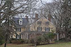
| 1 |
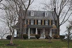
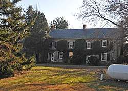
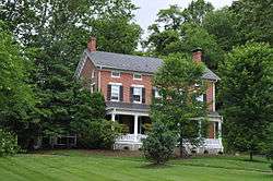
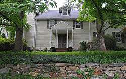
James B. Baker House |
|
December 10, 1982
(#82001593) |
452 W. Bel Air Ave.
39°30′45″N 76°10′25″W / 39.5125°N 76.173611°W / 39.5125; -76.173611 (James B. Baker House) |
Aberdeen |
|
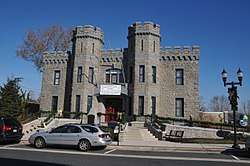
| 2 |
Bel Air Armory |
|
September 25, 1985
(#85002667) |
N. Main St.
39°32′15″N 76°21′01″W / 39.5375°N 76.350278°W / 39.5375; -76.350278 (Bel Air Armory) |
Bel Air |
|
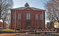
| 3 |
Bel Air Courthouse Historic District |
|
July 25, 1985
(#85001617) |
Office, Courtland, and Main Sts.
39°32′08″N 76°20′59″W / 39.535556°N 76.349722°W / 39.535556; -76.349722 (Bel Air Courthouse Historic District) |
Bel Air |
|
| 4 |
Berkley Crossroads Historic District |
|
July 17, 2003
(#03000649) |
Berkley Road and Castleton Rd.
39°39′46″N 76°12′19″W / 39.662778°N 76.205278°W / 39.662778; -76.205278 (Berkley Crossroads Historic District) |
Darlington |
|
| 5 |
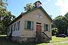
Berkley School |
|
July 22, 1988
(#88001011) |
Castleton Rd., Maryland Route 623
39°39′29″N 76°12′21″W / 39.658056°N 76.205833°W / 39.658056; -76.205833 (Berkley School) |
Darlington |
|
| 6 |
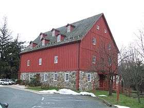
Best Endeavor |
|
December 28, 1990
(#90001993) |
1612 Calvary Rd.
39°30′12″N 76°15′55″W / 39.503333°N 76.265278°W / 39.503333; -76.265278 (Best Endeavor) |
Churchville |
|
| 7 |
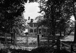
Bon Air |
|
November 10, 1977
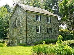
(#77000697) |
Laurel Brook Rd.
39°30′28″N 76°25′00″W / 39.507778°N 76.416667°W / 39.507778; -76.416667 (Bon Air) |
Fallston |
|
| 8 |
Broad Creek Soapstone Quarries |
|
May 12, 1975
(#75000903) |
Address Restricted
|
Whiteford |
|
| 9 |
Broom's Bloom |
|
December 19, 1991
(#91001778) |
1616 S. Fountain Green Rd.
39°30′44″N 76°17′01″W / 39.512222°N 76.283611°W / 39.512222; -76.283611 (Broom's Bloom) |
Bel Air |
|
| 10 |
Chestnut Ridge |
|
December 1, 1983
(#83003780) |
3850 W. Chapel Rd.
39°33′34″N 76°10′53″W / 39.559444°N 76.181389°W / 39.559444; -76.181389 (Chestnut Ridge) |
Aberdeen |
|
| 11 |
Church of the Holy Trinity |
|
December 27, 2002
(#02001580) |
2929 Level Rd.
39°33′39″N 76°14′48″W / 39.560833°N 76.246667°W / 39.560833; -76.246667 (Church of the Holy Trinity) |
Churchville |
|
| 12 |
Churchville Presbyterian Church |
|
August 21, 1986
(#86001733) |
Intersection of Maryland Routes 22 and 136
39°33′34″N 76°15′10″W / 39.559444°N 76.252778°W / 39.559444; -76.252778 (Churchville Presbyterian Church) |
Churchville |
|
| 13 |
D. H. Springhouse |
|
May 8, 1973
(#73000923) |
About 6 miles (9.7 km) northeast of Bel Air on Sandy Hook Rd.
39°37′17″N 76°18′37″W / 39.621389°N 76.310278°W / 39.621389; -76.310278 (D. H. Springhouse) |
Bel Air |
|
| 14 |
Darlington Historic District |
|
September 10, 1987
(#87001571) |
Main St., Shuresville Rd., Quaker Ln., Richmond Ave., and Trappe Church Rd.
39°38′23″N 76°12′03″W / 39.639722°N 76.200833°W / 39.639722; -76.200833 (Darlington Historic District) |
Darlington |
|
| 15 |
Deer Creek Friends Meetinghouse |
|
April 23, 1980
(#80001817) |
Maryland Route 161
39°38′46″N 76°12′19″W / 39.646111°N 76.205278°W / 39.646111; -76.205278 (Deer Creek Friends Meetinghouse) |
Darlington |
|
| 16 |
Dibb House |
|
March 18, 1980
(#80001812) |
East of Bel Air at 1737 Churchville Rd.
39°32′56″N 76°18′11″W / 39.548889°N 76.303056°W / 39.548889; -76.303056 (Dibb House) |
Bel Air |
|
| 17 |
Fair Meadows |
|
November 25, 1980
(#80004255) |
Creswell Rd.
39°29′57″N 76°15′58″W / 39.499167°N 76.266111°W / 39.499167; -76.266111 (Fair Meadows) |
Creswell |
|
| 18 |
Finney Houses Historic District |
|
June 16, 1989
(#89000502) |
Glenville Rd. near its junction with Maryland Route 155
39°34′20″N 76°14′20″W / 39.572222°N 76.238889°W / 39.572222; -76.238889 (Finney Houses Historic District) |
Churchville |
|
| 19 |
Gladden Farm |
|
May 28, 1993
(#93000444) |
3881 Rocks Station Rd.
39°38′27″N 76°24′22″W / 39.640833°N 76.406111°W / 39.640833; -76.406111 (Gladden Farm) |
Street |
|
| 20 |
Graham-Crocker House |
|
March 17, 1980
(#80001813) |
30 N. Main St.
39°32′12″N 76°21′01″W / 39.536667°N 76.350278°W / 39.536667; -76.350278 (Graham-Crocker House) |
Bel Air |
|
| 21 |
Gray Gables |
|
March 27, 1986
(#86000582) |
4528 Conowingo Rd.
39°39′13″N 76°13′15″W / 39.653611°N 76.220833°W / 39.653611; -76.220833 (Gray Gables) |
Darlington |
|
| 22 |
Graystone Lodge |
|
August 30, 2007
(#07000858) |
1118 Bel Air Rd.
39°30′44″N 76°22′24″W / 39.512222°N 76.373333°W / 39.512222; -76.373333 (Graystone Lodge) |
Bel Air |
|
| 23 |
Griffith House |
|
November 14, 1978
(#78001465) |
Southwest of Aberdeen at 1120 Old Philadelphia Rd.
39°29′18″N 76°11′41″W / 39.488333°N 76.194722°W / 39.488333; -76.194722 (Griffith House) |
Aberdeen |
|
| 24 |
Gunpowder Meetinghouse |
|
June 5, 1974
(#74000954) |
Magnolia Rd.
39°24′13″N 76°18′29″W / 39.403611°N 76.308056°W / 39.403611; -76.308056 (Gunpowder Meetinghouse) |
Aberdeen Proving Ground |
|
| 25 |
Harford Furnace Historic District |
|
July 18, 1990
(#90001020) |
Creswell and Goat Hill Rds.
39°29′36″N 76°15′38″W / 39.493333°N 76.260556°W / 39.493333; -76.260556 (Harford Furnace Historic District) |
Bel Air |
|
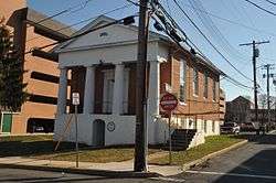
| 26 |
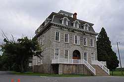
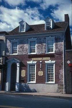
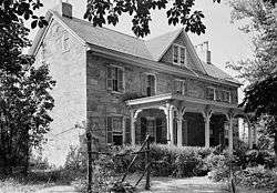
Harford National Bank |
|
March 20, 1980
(#80001814) |
Wall and Courtland Sts.
39°32′07″N 76°20′59″W / 39.535278°N 76.349722°W / 39.535278; -76.349722 (Harford National Bank) |
Bel Air |
Richardsonian Romanesque bank building now replaced by a court building |
| 27 |
Havre de Grace Historic District |
|
March 25, 1982
(#82002815) |
Roughly bounded by Chesapeake Bay, the Susquehanna River, U.S. Route 40, and Stokes, Juniata, and Superior Sts.
39°32′49″N 76°05′29″W / 39.546944°N 76.091389°W / 39.546944; -76.091389 (Havre de Grace Historic District) |
Havre de Grace |
|
| 28 |
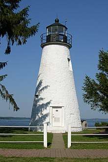
Havre de Grace Lighthouse |
|
April 2, 1976
(#76000999) |
Concord and Lafayette Sts.
39°32′26″N 76°05′07″W / 39.540556°N 76.085278°W / 39.540556; -76.085278 (Havre de Grace Lighthouse) |
Havre de Grace |
|
| 29 |
Hays House |
|
January 3, 1980
(#80001815) |
324 S. Kenmore Ave.
39°31′57″N 76°20′52″W / 39.5325°N 76.347778°W / 39.5325; -76.347778 (Hays House) |
Bel Air |
|
| 30 |
Hays-Heighe House |
|
February 11, 1972
(#72000581) |
401 Thomas Run Rd.
39°33′37″N 76°17′00″W / 39.560278°N 76.283333°W / 39.560278; -76.283333 (Hays-Heighe House) |
Bel Air |
|
| 31 |
Heighe House |
|
November 1, 1990
(#90001568) |
Junction of Southampton and Moores Mill Rds.
39°33′00″N 76°20′17″W / 39.55°N 76.338056°W / 39.55; -76.338056 (Heighe House) |
Bel Air |
|
| 32 |
Hidden Valley Farm |
|
January 17, 1983
(#83002950) |
2916 Green Rd.
39°31′35″N 76°29′59″W / 39.526389°N 76.499722°W / 39.526389; -76.499722 (Hidden Valley Farm) |
Baldwin |
|
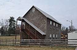
| 33 |
Husband Flint Mill Site |
|
June 18, 1975
(#75000902) |
Address Restricted
|
Kalmia |
|
| 34 |
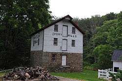
Ivory Mills |
|
August 29, 1997
(#97000968) |
4916 Harford Creamery Rd.
39°40′28″N 76°32′15″W / 39.674444°N 76.5375°W / 39.674444; -76.5375 (Ivory Mills) |
White Hall |
|
| 35 |
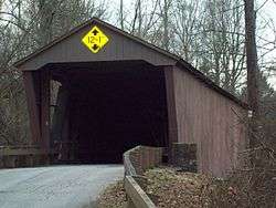
Jericho Covered Bridge |
|
September 13, 1978
(#78001444) |
East of Kingsville on Jericho Rd.
39°27′34″N 76°23′16″W / 39.459444°N 76.387778°W / 39.459444; -76.387778 (Jericho Covered Bridge) |
Jerusalem |
|
| 36 |
Jerusalem Mill Village |
|
August 20, 1987
(#87001400) |
Jerusalem and Jericho Rds.
39°27′41″N 76°23′23″W / 39.461389°N 76.389722°W / 39.461389; -76.389722 (Jerusalem Mill Village) |
Jerusalem |
|
| 37 |
Joshua's Meadows |
|
December 21, 1982
(#82001594) |
300 N. Tollgate Rd.
39°31′18″N 76°21′54″W / 39.521667°N 76.365°W / 39.521667; -76.365 (Joshua's Meadows) |
Bel Air |
|
| 38 |
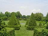
Ladew Topiary Gardens and House |
|
May 13, 1976
(#76001002) |
3535 Jarrettsville Pike (Maryland Route 146)
39°34′52″N 76°30′44″W / 39.581111°N 76.512222°W / 39.581111; -76.512222 (Ladew Topiary Gardens and House) |
Taylor |
Historic home and 1930s topiary gardens on a 250-acre (1.0 km2) estate. |
| 39 |
Liriodendron |
|
September 27, 1980
(#80001816) |
501 and 502 W. Gordon St.
39°32′01″N 76°21′40″W / 39.533611°N 76.361111°W / 39.533611; -76.361111 (Liriodendron) |
Bel Air |
|
| 40 |
Little Falls Meetinghouse |
|
May 7, 1980
(#80001818) |
Old Fallston Rd.
39°30′33″N 76°24′23″W / 39.509167°N 76.406389°W / 39.509167; -76.406389 (Little Falls Meetinghouse) |
Fallston |
|
| 41 |
Lower Deer Creek Valley Historic District |
|
November 3, 1993
(#93001143) |
Roughly bounded by the Susquehanna River, Maryland Route 543, and Harmony, Church, and Trappe Rds.
39°36′43″N 76°14′05″W / 39.611944°N 76.234722°W / 39.611944; -76.234722 (Lower Deer Creek Valley Historic District) |
Darlington |
|
| 42 |
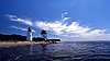
MARTHA LEWIS (skipjack) |
|
December 11, 2008
(#08001175) |
Millard Tydings Memorial Park, Commerce St. at S. Strawberry La.
39°32′18″N 76°05′25″W / 39.53839°N 76.09023°W / 39.53839; -76.09023 (MARTHA LEWIS (skipjack)) |
Havre de Grace |
Chesapeake Bay Skipjack Fleet TR |
| 43 |
McComas Institute |
|
September 8, 1980
(#80001819) |
North of Joppa on Singer Rd.
39°28′02″N 76°21′30″W / 39.467222°N 76.358333°W / 39.467222; -76.358333 (McComas Institute) |
Joppa |
|
| 44 |
Medical Hall Historic District |
|
August 28, 1973
(#73000926) |
West of Churchville off Maryland Route 154
39°34′24″N 76°16′20″W / 39.573333°N 76.272222°W / 39.573333; -76.272222 (Medical Hall Historic District) |
Churchville |
|
| 45 |
Mill Green Historic District |
|
June 3, 1993
(#93000445) |
Junction of Mill Green and Prospect Rds.
39°39′50″N 76°19′34″W / 39.663889°N 76.326111°W / 39.663889; -76.326111 (Mill Green Historic District) |
Street |
|
| 46 |
Mount Adams |
|
October 27, 1988
(#88002062) |
1912 Fountain Green Rd.
39°30′27″N 76°16′52″W / 39.5075°N 76.281111°W / 39.5075; -76.281111 (Mount Adams) |
Bel Air |
|
| 47 |
My Lady's Manor |
|
April 15, 1978
(#78001445) |
Maryland Route 138
39°35′15″N 76°34′16″W / 39.5875°N 76.571111°W / 39.5875; -76.571111 (My Lady's Manor) |
Jarrettsville |
|
| 48 |
Nelson-Reardon-Kennard House |
|
April 15, 1991
(#91000001) |
3604 Philadelphia Rd.
39°27′51″N 76°16′45″W / 39.464167°N 76.279167°W / 39.464167; -76.279167 (Nelson-Reardon-Kennard House) |
Abingdon |
|
| 49 |
Norris-Stirling House |
|
May 30, 1979
(#79001135) |
Ring Factory Rd.
39°29′26″N 76°21′31″W / 39.490556°N 76.358611°W / 39.490556; -76.358611 (Norris-Stirling House) |
Bel Air |
|
| 50 |
Odd Fellows Lodge |
|
August 22, 1975
(#75000901) |
21 Pennsylvania Ave.
39°32′13″N 76°20′56″W / 39.536944°N 76.348889°W / 39.536944; -76.348889 (Odd Fellows Lodge) |
Bel Air |
|
| 51 |
Old Joppa Site |
|
August 24, 1979
(#79001136) |
Address Restricted
|
Joppatowne |
|
| 52 |
Olney |
|
July 9, 1987
(#87001197) |
1001 Old Joppa Rd.
39°28′39″N 76°22′11″W / 39.4775°N 76.369722°W / 39.4775; -76.369722 (Olney) |
Joppa |
|
| 53 |
Pooles Island Lighthouse |
|
February 19, 1997
(#97000060) |
Northwestern portion of Poole's Island and southeast of Rickett Point at Aberdeen Proving Ground
39°17′26″N 76°15′59″W / 39.2905°N 76.2664°W / 39.2905; -76.2664 (Pooles Island Lighthouse) |
Edgewood |
|
| 54 |
Poplar Hill |
|
May 28, 1976
(#76000998) |
115 Poplar Hill Rd.
39°29′46″N 76°10′17″W / 39.496111°N 76.171389°W / 39.496111; -76.171389 (Poplar Hill) |
Aberdeen |
|
| 55 |
Presbury Meetinghouse |
|
May 23, 1974
(#74000955) |
Austin and Parrish Rds.
39°23′15″N 76°18′24″W / 39.3875°N 76.306667°W / 39.3875; -76.306667 (Presbury Meetinghouse) |
Aberdeen Proving Ground |
|
| 56 |
Priest Neal's Mass House and Mill Site |
|
March 15, 1990
(#90000352) |
2618 Cool Spring Rd.
39°35′55″N 76°15′33″W / 39.598611°N 76.259167°W / 39.598611; -76.259167 (Priest Neal's Mass House and Mill Site) |
Bel Air |
|
| 57 |
Proctor House |
|
March 23, 1990
(#90000376) |
54 E. Gordon St.
39°32′24″N 76°21′06″W / 39.54°N 76.351667°W / 39.54; -76.351667 (Proctor House) |
Bel Air |
|
| 58 |
Rigbie House |
|
August 14, 1973
(#73000925) |
Southeast of Berkley off Maryland Route 623
39°39′37″N 76°12′12″W / 39.660278°N 76.203333°W / 39.660278; -76.203333 (Rigbie House) |
Berkley |
|
| 59 |
Rockdale |
|
June 30, 1982
(#82002814) |
North of Fallston at 1724 Carrs Mill Rd.
39°32′03″N 76°24′19″W / 39.534167°N 76.405278°W / 39.534167; -76.405278 (Rockdale) |
Fallston |
|
| 60 |
St. George's Parish Vestry House |
|
March 26, 1976
(#76001001) |
1522 Perryman Rd.
39°28′27″N 76°12′16″W / 39.474167°N 76.204444°W / 39.474167; -76.204444 (St. George's Parish Vestry House) |
Perryman |
|
| 61 |
St. Ignatius Church |
|
April 16, 1974
(#74000956) |
533 E. Jarrettsville Rd.
39°34′25″N 76°21′19″W / 39.573611°N 76.355278°W / 39.573611; -76.355278 (St. Ignatius Church) |
Forest Hill |
|
| 62 |
St. Mary's Church |
|
March 30, 1973
(#73000928) |
South of Emmorton on Maryland Route 24
39°29′16″N 76°19′04″W / 39.487778°N 76.317778°W / 39.487778; -76.317778 (St. Mary's Church) |
Emmorton |
|
| 63 |
Silver Houses Historic District |
|
September 7, 1984
(#84001800) |
South of Darlington on Maryland Route 161
39°36′22″N 76°11′47″W / 39.606111°N 76.196389°W / 39.606111; -76.196389 (Silver Houses Historic District) |
Darlington |
|
| 64 |
Sion Hill |
|
April 30, 1990
(#90000608) |
2026 Level Rd.
39°33′42″N 76°07′32″W / 39.561667°N 76.125556°W / 39.561667; -76.125556 (Sion Hill) |
Havre de Grace |
Historic home of U.S. Navy officers including Commodore John Rodgers. |
| 65 |
Slate Ridge School |
|
July 16, 1987
(#87000657) |
Old Pylesville Rd.
39°42′45″N 76°20′25″W / 39.7125°N 76.340278°W / 39.7125; -76.340278 (Slate Ridge School) |
Whiteford |
|
| 66 |
Sophia's Dairy |
|
September 20, 1973
(#73000922) |
Southwest of Aberdeen off U.S. Route 40
39°28′24″N 76°14′03″W / 39.473333°N 76.234167°W / 39.473333; -76.234167 (Sophia's Dairy) |
Aberdeen |
|
| 67 |
Southern Terminal, Susquehanna and Tidewater Canal |
|
May 28, 1976
(#76001000) |
North of Erie St. between Conesteo St. and the Susquehanna River
39°33′24″N 76°05′41″W / 39.556667°N 76.094722°W / 39.556667; -76.094722 (Southern Terminal, Susquehanna and Tidewater Canal) |
Havre de Grace |
|
| 68 |
Col. John Streett House |
|
July 16, 1990
(#90001022) |
Northern side of Holy Cross Rd. east of Deer Creek
39°39′27″N 76°26′04″W / 39.6575°N 76.434444°W / 39.6575; -76.434444 (Col. John Streett House) |
Street |
|
| 69 |
Swansbury |
|
July 15, 1994
(#94000730) |
Beard's Hill Rd. Extended, northeast of Aberdeen
39°31′18″N 76°09′11″W / 39.521667°N 76.153056°W / 39.521667; -76.153056 (Swansbury) |
Aberdeen |
|
| 70 |
Thomas Run Church |
|
January 3, 1978
(#78001466) |
Northeast of Bel Air off Maryland Route 136
39°35′32″N 76°17′34″W / 39.592222°N 76.292778°W / 39.592222; -76.292778 (Thomas Run Church) |
Bel Air |
|
| 71 |
Tudor Hall |
|
March 14, 1973
(#73000924) |
Northeast of Bel Air off Maryland Route 22
39°33′15″N 76°18′11″W / 39.554167°N 76.303056°W / 39.554167; -76.303056 (Tudor Hall) |
Bel Air |
|
| 72 |
The Vineyard |
|
July 22, 1994
(#94000762) |
1201 Conowingo Rd. (U.S. Route 1)
39°33′56″N 76°20′34″W / 39.565556°N 76.342778°W / 39.565556; -76.342778 (The Vineyard) |
Bel Air |
|
| 73 |
Webster's Forest |
|
September 1, 1983
(#83002951) |
500 Asbury Rd.
39°32′32″N 76°15′51″W / 39.542222°N 76.264167°W / 39.542222; -76.264167 (Webster's Forest) |
Churchville |
|
| 74 |
Whitaker's Mill Historic District |
|
July 16, 1990
(#90001021) |
1210, 1212, and 1213 Whitaker Mill Rd.
39°29′51″N 76°21′15″W / 39.4975°N 76.354167°W / 39.4975; -76.354167 (Whitaker's Mill Historic District) |
Joppa |
|
| 75 |
Whiteford-Cardiff Historic District |
|
November 15, 2005
(#05001278) |
Whiteford Rd., Platted Parry St., Quarry Rd., west of Main St.; split between Maryland and Pennsylvania
39°42′56″N 76°20′19″W / 39.715556°N 76.338611°W / 39.715556; -76.338611 (Whiteford-Cardiff Historic District) |
Whiteford |
|
| 76 |
Wildfell |
|
September 20, 1973
(#73000927) |
Northwest of Darlington on U.S. Route 1
39°39′04″N 76°13′11″W / 39.651111°N 76.219722°W / 39.651111; -76.219722 (Wildfell) |
Darlington |
|
| 77 |
Winsted |
|
September 19, 1979
(#79003266) |
North of Aberdeen at 3844 W. Chapel Rd.
39°33′36″N 76°10′54″W / 39.56°N 76.181667°W / 39.56; -76.181667 (Winsted) |
Aberdeen |
|
| 78 |
Woodside |
|
November 1, 1979
(#79001134) |
Northwest of Abingdon at 400 Singer Rd
39°28′47″N 76°19′22″W / 39.479722°N 76.322778°W / 39.479722; -76.322778 (Woodside) |
Abingdon |
|
| 79 |
Woodview |
|
October 25, 1990
(#90001574) |
1236 Somerville Rd.
39°29′47″N 76°20′56″W / 39.496389°N 76.348889°W / 39.496389; -76.348889 (Woodview) |
Bel Air |
|

_-_Harford_National_Bank%2C_Bel_Air%2C_Harford_County%2C_MD.jpg)
_Left_Side.JPG)