Cunningham Falls State Park
| Cunningham Falls State Park | |
| Maryland State Park | |
 The longest cascading waterfall in Maryland | |
| Country | United States |
|---|---|
| State | Maryland |
| County | Frederick |
| Elevation | 1,247 ft (380 m) [1] |
| Coordinates | 39°37′53″N 77°28′17″W / 39.63139°N 77.47139°WCoordinates: 39°37′53″N 77°28′17″W / 39.63139°N 77.47139°W [1] |
| Area | 6,077 acres (2,459 ha) [2] |
| - Wildlands | 4,397 acres (1,779 ha) [2] |
| Established | 1954 [3] |
| Management | Maryland Department of Natural Resources |
| IUCN category | V[4] |
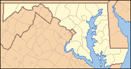 Location in Maryland | |
| Website: Cunningham Falls State Park | |
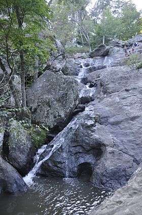
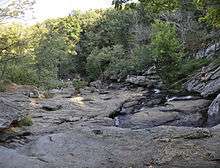
Cunningham Falls State Park is a public recreation area located west of Thurmont, Maryland, in the United States. The state park is the home of Cunningham Falls, the largest cascading waterfall in Maryland, a 43-acre (17 ha) man-made lake, and the remains of a historic iron furnace.[5] The park is one of several protected areas occupying 50-mile-long Catoctin Mountain; it is bordered on its north by Catoctin Mountain Park and on its south by Frederick Municipal Forest.
History
Before the arrival of European settlers, Native Americans used the Catoctin Mountain area for hunting and fishing and also quarried it for rhyolite to make projectile points.[6] During the 19th century, settlers began cutting the area's forests for charcoal to power the Catoctin Iron Furnace. "Charcoal flats"—square areas measuring approximately 25 by 25 feet (7.6 by 7.6 m), cut flat into the hillsides and linked by mule trails—were used to build charcoal kilns. The charcoal flats can still be seen in the park.
Over two hundred years of abuse of the forest led to the destruction of the land.[7] In the 1930s, after years of clearcutting for the making of charcoal, mountain farming, and timber harvesting, the land was purchased by the Federal government. Beginning in 1935, workers with the Works Progress Administration and the Civilian Conservation Corps began constructing the Catoctin Recreational Demonstration Area to transform the area for recreational use. The site's northern portion was transferred to the National Park Service on November 14, 1936, and renamed and reorganized on July 12, 1954, as Catoctin Mountain Park. The southern 5,000 acres (2,000 ha) were transferred to Maryland as Cunningham Falls State Park.[8]
Features
- Waterfalls and formations
Known locally, as McAfee Falls, after a family of early settlers,[9] 78-foot (24 m) Cunningham Falls was apparently named after a photographer from Pen Mar Park who frequently photographed the falls.[7]
An old homestead can be seen above the falls. There is an abandoned iron, copper, or gold mine, located in the park, in addition to the ruins of the third Catoctin iron furnace, owned and constructed by Jacob Kinkel, in the 1850s-1860s.
Activities and amenities
Recreational activities include hiking, hunting, swimming, boating, fishing, and camping. Big Hunting Creek, one of Maryland's premier trout streams, flows through the park.[10]
Further reading
- Means, John. Maryland's Catoctin Mountain Parks. Blacksburg, Va.:McDonald & Woodward Publishing. 1995. ISBN 0-939923-38-6.
References
- 1 2 "Cunningham Falls". Geographic Names Information System. United States Geological Survey.
- 1 2 "Fiscal Year 2016 DNR Owned Lands Acreage" (PDF). Maryland Department of Natural Resources. July 29, 2016. Retrieved November 3, 2017.
- ↑ "Source Water Assessment for Cunningham Falls State Park" (PDF). Maryland Department of the Environment. April 22, 2003. Retrieved January 8, 2014.
- ↑ "Cunningham Falls State Park". Protected Planet. IUCN. Retrieved 1 May 2018.
- ↑ "Cunningham Falls State Park". Maryland Department of Natural Resources. Retrieved January 8, 2014.
- ↑ Wehrle, Edmund F. (March 2000). "Settling the Catoctins". Catoctin Mountain Park Historic Resource Study. National Park Service. Retrieved July 15, 2015.
- 1 2 Miller, Jennifer (2011). "The Demonstration Succeeds" (PDF). The Mountaineer: Catoctin Mountain Park News: Special 75th-Anniversary Edition. National Park Service. p. 4. Retrieved January 8, 2014.
- ↑ Strain, Paula M. (1993). The Blue Hills of Maryland. Potomac Appalachian Trail Club. pp. 257–260. ISBN 978-0915746453.
- ↑ "Cunningham Falls". The Historical Marker Database. Retrieved January 8, 2014.
- ↑ "Big Hunting Creek". Maryland Department of Natural Resources. Retrieved July 15, 2015.
External links
| Wikimedia Commons has media related to Cunningham Falls State Park. |
- Cunningham Falls State Park Maryland Department of Natural Resources
- Cunningham Falls State Park Map Maryland Department of Natural Resources
