Canoe Landing Prairie State Natural Area
| Canoe Landing Prairie State Natural Area | |
| Wisconsin State Natural Area | |
 Canoe Landing Prairie | |
| Country | United States |
|---|---|
| State | Wisconsin |
| County | Eau Claire |
| Location | Augusta |
| - coordinates | 44°43′59″N 90°59′8″W / 44.73306°N 90.98556°WCoordinates: 44°43′59″N 90°59′8″W / 44.73306°N 90.98556°W |
| Area | 44 acres (18 ha) |
| Founded | 2006 |
| Owner | Eau Claire County |
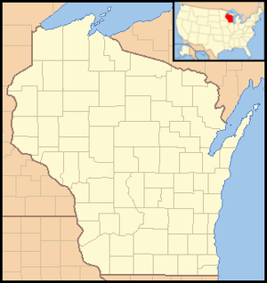 Location of Canoe Landing Prairie State Natural Area in Wisconsin | |
Canoe Landing Prairie is a Wisconsin Department of Natural Resources-designated State Natural Area featuring a diverse Hill's oak barrens and prairie community growing on the gently rolling, sandy uplands near the Eau Claire River. Plant composition includes the following species: Big bluestem, side-oats grama, butterfly weed, blue toadflax, and birdsfoot violet. Wild lupine is also found in the prairie, and supports a population of the karner blue butterfly, an endangered species whose caterpillars feed solely on wild lupine.[1] [2]
Location and access
Canoe Landing Prairie is located within the Eau Claire County Forest, in eastern Eau Claire County, approximately 7.5 miles (12.1 km) northeast of Augusta. Access is via Canoe Landing Forest Road, which bisects the area from north-east to south-west.[3]
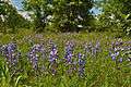 Wild lupine photographed at Canoe Landing Prairie
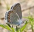 The endangered Karner blue, photographed at Canoe Landing Prairie
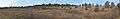 Late autumn panorama
References
- ↑ "Canoe Landing Prairie State Natural Area". Wisconsin Department of Natural Resources. Retrieved 2013-12-01.
- ↑ "Karner Blue Butterfly". US Fish & Wildlife Service. Retrieved 2013-12-01.
- ↑ Canoe Landing Prairie State Natural Area (PDF) (Map). Wisconsin Department of Natural Resources. Retrieved 2013-12-01.