Old World Wisconsin

Old World Wisconsin
Wisconsin Historical Society site
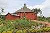
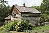
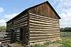
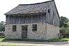
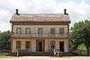
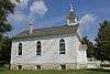
Koepsel House at Old World Wisconsin
Country United States
State Wisconsin
County Eagle
Location Eagle, Wisconsin, United States
 - coordinates 42°51′50″N 88°29′16″W / 42.86389°N 88.48778°W / 42.86389; -88.48778Coordinates: 42°51′50″N 88°29′16″W / 42.86389°N 88.48778°W / 42.86389; -88.48778
Area 480 acres (194 ha)
Founded 1976
Management Wisconsin Historical Society
IUCN category V - Protected Landscape/Seascape
Website: oldworldwisconsin.wisconsinhistory.org

Old World Wisconsin is an open-air museum located near Eagle, in Waukesha County, Wisconsin, United States. It depicts housing and the daily life of settlers in 19th-century Wisconsin, with separate areas representing the traditions of different ethnic groups who settled in the state. Costumed interpreters portray the occupations and chores of typical settlers of the time.

Overview

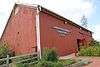
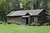
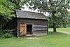
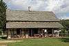
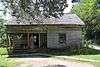
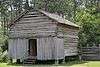
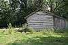
Opened in 1976, the museum is owned and operated by the Wisconsin Historical Society. The largest outdoor museum of rural life in the United States, it encompasses approximately 480 acres[1] (2.4 km²) of rolling wooded hills. It contains more than 60 historic structures, ranging from ethnic farmsteads with furnished houses and rural outbuildings to an 1880s crossroads village with traditional small town institutions. A restaurant, gift shop, and conference space are located in the octagonal Clausing Barn. Trams run between the Scandinavian and German, African-American, and Crossroads villages.

History

Old World Wisconsin exists largely due to the efforts of German immigrant Hans Kuether and architect Richard W. E. Perrin.[2] Perrin was an early advocate for the preservation of historic structures as evidenced by his involvement with the Association for the Preservation of Historic Buildings and with the preservation of the Mitchell-Rountree House in Platteville, Wisconsin in 1959.[3] Perrin published a guide book in 1960 titled Historic Wisconsin Architecture listing 76 structures in Wisconsin that he felt were worthy of preservation.[4] Perrin first proposed the idea for an outdoor museum in 1964 in the form of a "Pioneer Park".[5][6] Perrin's inspiration for the park actually dated back to a trip he made to Europe in 1953 and visited European outdoor museums including Skansen in Sweden which he used as his model for the Wisconsin Park.[2]

The effort to actually create the museum began in 1966, when the University of Wisconsin Department of Landscape Architucture and the Wisconsin Historical Society, agreed to have an undergraduate class at the university prepare preliminary plans for an outdoor museum.[7] The proposals created were published in a report titled "Heritage Village, Wisconsin – A Preliminary Proposal". Following this, two graduate students were selected to refine and expand the preliminary programs through research, on-site investigations and design studies and create a master plan for development. The study was co-funded by the College of Agricultural and Life Sciences and the State Historical Society at a cost of under $5,000. In 1968, the master plan was summarized in a 122-page report which also included an economic feasibility study by a graduate student in the School of Business. The project was named Old World Wisconsin and the Heritage wording was later applied to the Heritage Hill State Historical Park near Green Bay, Wisconsin.

Fundraising for purchase of property estimated at $30,000 were begun in January 1969.[8] In June 1971 it was announced that the Wisconsin Department of Natural Resources would transfer about 560 acres of property that was then part of the Kettle Moraine State Forest to the State Historical Society for the museum. Development costs were estimated at about $1.5 million at that time with about 20% of that coming from private donors.

Development of the park was intended to start in 1972 and the Historical Society had already moved 11 dismantled structures to the site but work was delayed until 1973 pending completion of an environmental impact study.[9] A dispute arose in 1973 with the Town of Eagle. The residents of the town were concerned about the impact the environmental impact statement revealed that the development of the museum would have on their town and the town board became concerned over lack of control by local zoning and building permits.[10] The board had directed the town's building inspector to post a stop-work order at the site.[11] The state filed a suit to vacate the order and $50,000 damages. The town countersued for $5,000,000 claiming that newly passed state law required the state to follow local zoning ordinances. The court lifted the order stating that work had started at the site before the law took effect on August 1 and was therefore exempt from the new rule.[12] The town did not give up on their lawsuit until November 1974.[13]

The park was dedicated on June 8, 1974 with a flag-raising ceremony. At the time there were 8 structures completed or under construction.[14]

In May 1975, the society reported that construction was still on schedule but that estimated costs had risen from $2.3 million to $4.5 million but that donations had only produced about $1 million.[15]

In December 1975 Wisconsin Governor Patrick Lucey announced that a $4 million fund raising campaign would be chaired by Herbert Kohler Jr. and his wife Linda.[16] The Kohler family already had a 45-year history of historic building construction and restoration through the Kohler Foundation dating back to the 1931 construction of the Waelderhaus and the 1950s restoration of the Sylvanus Wade House.

The queen of Denmark, Margrethe II dedicated the Danish exhibit on May 14, 1976.[17]

The museum officially opened on June 30, 1976 in time for the United States Bicentennial celebration.[18]

Tornado damage

On the evening of June 21, 2010, the museum was hit by a tornado that leveled acres of trees on the grounds.[19] The "Old World 4th of July" event was canceled because of the clean-up efforts.

Villages

The park is divided into themed areas that represent typical settlement from various immigrant cultures.

Live Interpreter with oxen
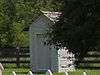
  • African American: Pleasant Ridge Cemetery Chapel, Shepard Family Cemetery, United Brethren Church, Pleasant Ridge Cemetery
  • Danish: Pedersen Farm
  • Finnish: Rankinen Farm, Ketola Farm
  • German: Koepsel Farm, Schottler Farm, Schulz Farm
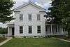
    • Christian Turck House was originally known as Schottler Farm. Both the Koepsel House and Christian Turck House are listed on the National Register of Historic Places. .[20][21]
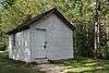
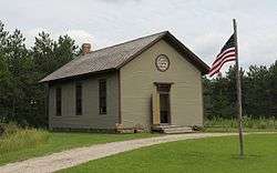
  • Norwegian: Fossebrekke Farm, Kvaale Farm, Raspberry School[22]
  • Polish: Kruza House
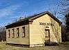
  • Yankee/1880's Village: Harmony Town Hall, Four Mile Inn, Sisel Shoe Shop, Benson House, Grotelueschen Blacksmith Shop, Peterson Wagon Shop, Thomas General Store, Mary Hafford House, St. Peter's Church and a new exhibit added in 2014, Catch Wheel Fever
    • Yankee Village also contains non-Yankee buildings featuring the integration of other European settlers to Wisconsin in the 19th century:
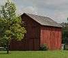
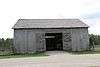
List of structures

Three of the site's structures are listed on the National Register of Historic Places. Buildings were relocated from locations throughout Wisconsin.

Structure nameVillagelocationImageBuiltConstruction/style/notes
Bicycle ShopThe Green42°52′15″N 88°29′22″W / 42.870732°N 88.489350°W / 42.870732; -88.489350 (Bicycle Shop)
Caldwell Hall Education CenterThe Green42°52′14″N 88°29′22″W / 42.870523°N 88.489429°W / 42.870523; -88.489429 (Caldwell Hall)
Clausing Barn/Gift ShopThe Green42°52′21″N 88°29′27″W / 42.872608°N 88.490737°W / 42.872608; -88.490737 (Clausing Barn)
PergolaThe Green42°52′19″N 88°29′26″W / 42.871920°N 88.490589°W / 42.871920; -88.490589 (Pergola)2016
Ramsey BarnThe Green42°52′17″N 88°29′27″W / 42.871382°N 88.490823°W / 42.871382; -88.490823 (Ramsey Barn)
ShelterThe Green42°52′18″N 88°29′26″W / 42.871668°N 88.490589°W / 42.871668; -88.490589 (Shelter)
Guest Services/Family History CenterThe Green42°52′19″N 88°29′26″W / 42.872080°N 88.490572°W / 42.872080; -88.490572 (Guest Services)
United Brethren ChurchAfrican-American42°52′02″N 88°29′49″W / 42.867242°N 88.496876°W / 42.867242; -88.496876 (United Brethren Church)
Pleasant Ridge ChapelAfrican-American42°52′03″N 88°29′43″W / 42.867566°N 88.495333°W / 42.867566; -88.495333 (Pleasant Ridge Chapel)
Pleasant Ridge CemeteryAfrican-American42°52′03″N 88°29′48″W / 42.867548°N 88.496626°W / 42.867548; -88.496626 (Pleasant Ridge Cemetery)
Shepard Family CemeteryAfrican-American42°52′04″N 88°29′43″W / 42.867677°N 88.495414°W / 42.867677; -88.495414 (Shepard Family Cemetery)
Pedersen HouseDanish42°51′43″N 88°29′24″W / 42.861953°N 88.490058°W / 42.861953; -88.490058 (Pederson House)1872[23]moved from Polk County[23]
Pedersen BarnDanish42°51′43″N 88°29′26″W / 42.861824°N 88.490488°W / 42.861824; -88.490488 (Pederson Barn)early 1870s [23]moved from Polk County[23]
Ketola BarnFinnish42°51′56″N 88°29′29″W / 42.865568°N 88.491266°W / 42.865568; -88.491266 (Ketola Barn)Moved from Oulu, Bayfield County
Ketola HouseFinnish42°51′55″N 88°29′30″W / 42.865278°N 88.491531°W / 42.865278; -88.491531 (Ketola House)Log[24] Moved from Oulu, Bayfield County
Lantta Hay Barn
(Ketola Farm)
Finnish42°51′53″N 88°29′29″W / 42.864850°N 88.491474°W / 42.864850; -88.491474 (Lantta Hay Barn)
Ronkainen Sauna
(Ketola Farm)
Finnish42°51′54″N 88°29′28″W / 42.865137°N 88.491223°W / 42.865137; -88.491223 (Ronkainen Sauna)
Kortesmaa Granary
(Ketola Farm)
Finnish42°51′55″N 88°29′28″W / 42.865292°N 88.491181°W / 42.865292; -88.491181 (Kortesmaa Granary)
Makela Stable
(Ketola Farm)
Finnish42°51′56″N 88°29′28″W / 42.865456°N 88.491179°W / 42.865456; -88.491179 (Makela Stable)
Rankinen Outhouse
(Ketola Farm)
Finnish42°51′56″N 88°29′28″W / 42.865536°N 88.491135°W / 42.865536; -88.491135 (Rankinen Outhouse)
Rankinen HouseFinnish42°51′57″N 88°29′24″W / 42.865910°N 88.490011°W / 42.865910; -88.490011 (Rankinen House)
Rankinen BarnFinnish42°51′56″N 88°29′25″W / 42.865651°N 88.490219°W / 42.865651; -88.490219 (Rankinen Barn)
Kortesmaa Outhouse
(Rankinen Farm)
Finnish42°51′56″N 88°29′25″W / 42.865583°N 88.490195°W / 42.865583; -88.490195 (Kortesmaa Outhouse)
Koepsel HouseGerman42°51′59″N 88°29′51″W / 42.866347°N 88.497387°W / 42.866347; -88.497387 (Koepsel House)1860[25]Listed on the NRHP in 1973 (#73000095)
Barn
(Koepsel Farm)
German42°51′58″N 88°29′52″W / 42.866163°N 88.497776°W / 42.866163; -88.497776 (Koepsel Barn)
Brewing Shed
(Koepsel Farm)
German42°52′01″N 88°29′55″W / 42.866807°N 88.498581°W / 42.866807; -88.498581 (Koepsel Brewing Shed)
Outhouse
(Koepsel Farm)
German42°51′58″N 88°29′51″W / 42.866094°N 88.497472°W / 42.866094; -88.497472 (Koepsel Outhouse)
Stable
(Koepsel Farm)
German42°51′59″N 88°29′53″W / 42.866345°N 88.497924°W / 42.866345; -88.497924 (Koepsel Stable)1850[26]Astylistic Utilitarian. Moved to Old World Wisconsin from town of Emmet, Dodge County, west side of County Road EM, 1.1 miles north of State Road 109
Hog pen
(Koepsel Farm)
German42°52′00″N 88°29′51″W / 42.866631°N 88.497474°W / 42.866631; -88.497474 (Koepsel Pen)
Wood Shop
(Koepsel Farm)
German42°51′59″N 88°29′52″W / 42.866472°N 88.497788°W / 42.866472; -88.497788 (Koepsel Wood shop)
Schultz HouseGerman42°51′54″N 88°29′52″W / 42.864978°N 88.497693°W / 42.864978; -88.497693 (Schultz House)
Schultz BarnGerman42°51′56″N 88°29′52″W / 42.865447°N 88.497717°W / 42.865447; -88.497717 (Schultz Barn)
Schultz StableGerman42°51′55″N 88°29′52″W / 42.865244°N 88.497901°W / 42.865244; -88.497901 (Schultz Stable)
Schottler HouseGerman42°51′56″N 88°29′57″W / 42.865566°N 88.499292°W / 42.865566; -88.499292 (Schottler House)1846[27]Cedar log house chinked with rye straw and clay, built in Washington County. Listed on the NRHP in 1973 (#73000097) as Christian Turck House
Held Barn
(Schottler farm)
German42°51′56″N 88°29′58″W / 42.865435°N 88.499535°W / 42.865435; -88.499535 (Held Barn)
Jung Barn
(Schottler farm)
German42°51′55″N 88°29′58″W / 42.865289°N 88.499378°W / 42.865289; -88.499378 (Jung Barn)
Fassbender Granary
(Schottler farm)
German42°51′55″N 88°29′57″W / 42.865295°N 88.499144°W / 42.865295; -88.499144 (Fassbender Granary)
Kessel Bakehouse
(Schottler farm)
German42°51′56″N 88°29′57″W / 42.865421°N 88.499217°W / 42.865421; -88.499217 (Kessel Bakehouse)
Jung Smokehouse
(Schottler farm)
German42°51′56″N 88°29′57″W / 42.865516°N 88.499087°W / 42.865516; -88.499087 (Jung Smokehouse)
Abandoned HouseNorwegian42°51′32″N 88°29′26″W / 42.858767°N 88.490477°W / 42.858767; -88.490477 (Abandoned House)
Abandoned BarnNorwegian42°51′31″N 88°29′27″W / 42.858536°N 88.490749°W / 42.858536; -88.490749 (Abandoned Barn)
Kvaale HouseNorwegian42°51′32″N 88°29′38″W / 42.858800°N 88.493865°W / 42.858800; -88.493865 (Kvaale House)
Dahlen Corncrib
(Kvaale Farm)
Norwegian42°51′32″N 88°29′39″W / 42.858938°N 88.494161°W / 42.858938; -88.494161 (Dahlen Corncrib)
Sorbergshagen Barn
(Kvaale Farm)
Norwegian42°51′32″N 88°29′40″W / 42.858925°N 88.494453°W / 42.858925; -88.494453 (Sorbergshagen Barn)
Lisbakken Granery
(Kvaale Farm)
Norwegian42°51′31″N 88°29′40″W / 42.858707°N 88.494485°W / 42.858707; -88.494485 (Lisbakken Granery)
Bosboen Barn
(Kvaale Farm)
Norwegian42°51′31″N 88°29′39″W / 42.858528°N 88.494209°W / 42.858528; -88.494209 (Bosboen Barn)
Otteson Outhouse
(Kvaale Farm)
Norwegian42°51′31″N 88°29′38″W / 42.858627°N 88.493951°W / 42.858627; -88.493951 (Otteson Outhouse)
Veggli House
(Kvaale Farm)
Norwegian42°51′31″N 88°29′38″W / 42.858607°N 88.493803°W / 42.858607; -88.493803 (Veggli House)
Fossebrekke HouseNorwegian42°51′34″N 88°29′37″W / 42.859347°N 88.493674°W / 42.859347; -88.493674 (Fossebrekke House)1845 (oldest building on site)[28]
Raspberry SchoolhouseNorwegian42°51′33″N 88°29′33″W / 42.859044°N 88.492403°W / 42.859044; -88.492403 (Raspberry Schoolhouse)
Ward District Schoolhouse No. 3Norwegian42°51′27″N 88°29′37″W / 42.857570°N 88.493729°W / 42.857570; -88.493729 (Ward District Scholhouse No. 3)1849[29]Greek Revival, Listed on the NRHP in 1981 (#81000066)
Kruza HousePolish42°51′52″N 88°29′57″W / 42.864375°N 88.499057°W / 42.864375; -88.499057 (Kruza House)
Kaczorowski OuthousePolish42°51′51″N 88°29′56″W / 42.864283°N 88.498937°W / 42.864283; -88.498937 (Kaczorowski Outhouse)
Roadside CrossPolish42°51′53″N 88°29′56″W / 42.864729°N 88.498945°W / 42.864729; -88.498945 (Roadside Cross)
Benson HouseYankee/1880s Village42°52′06″N 88°29′30″W / 42.868348°N 88.491758°W / 42.868348; -88.491758 (Benson House)
Benson BarnYankee/1880s Village42°52′06″N 88°29′32″W / 42.868393°N 88.492228°W / 42.868393; -88.492228 (Benson Barn)
Benson GezeboYankee/1880s Village42°52′06″N 88°29′31″W / 42.868322°N 88.492029°W / 42.868322; -88.492029 (Benson Gezebo)
Blacksmith ShopYankee/1880s Village42°52′07″N 88°29′30″W / 42.868508°N 88.491727°W / 42.868508; -88.491727 (Blacksmith Shop)
Hafford HouseYankee/1880s Village42°52′09″N 88°29′32″W / 42.869225°N 88.492237°W / 42.869225; -88.492237 (Hafford House)
Four Mile HouseYankee/1880s Village42°52′05″N 88°29′30″W / 42.867983°N 88.491581°W / 42.867983; -88.491581 (Four Mile House)
Harmony Town HallYankee/1880s Village42°52′03″N 88°29′22″W / 42.867524°N 88.489458°W / 42.867524; -88.489458 (Harmony Town Hall)1876[30]Front Gabled. Originally build it Town of Harmony in Rock County. Moved to Old World Wisconsin in October, 1976.
Peterson Wagon ShopYankee/1880s Village42°52′07″N 88°29′30″W / 42.868664°N 88.491753°W / 42.868664; -88.491753 (Peterson Wagon Shop)
Sisel Shoe ShopYankee/1880s Village42°52′05″N 88°29′31″W / 42.868014°N 88.492082°W / 42.868014; -88.492082 (Sisel Shoe Shop)
Sisel BarnYankee/1880s Village42°52′04″N 88°29′32″W / 42.867676°N 88.492207°W / 42.867676; -88.492207 (Sisel Barn)
StageYankee/1880s Village42°52′07″N 88°29′29″W / 42.868508°N 88.491284°W / 42.868508; -88.491284 (Stage)
Thomas General StoreYankee/1880s Village42°52′07″N 88°29′29″W / 42.868677°N 88.491337°W / 42.868677; -88.491337 (Thomas General Store)1876[31]Front gabled limestone. Moved to Old World Wisconsin in 1992 from the SE corner of Hwy 18 and Waterville Road in Waukesha County.
Barn
(Thomas Store)
Yankee/1880s Village42°52′08″N 88°29′28″W / 42.868886°N 88.491025°W / 42.868886; -88.491025 (Thomas Barn)
Outhouse
(Thomas Store)
Yankee/1880s Village42°52′07″N 88°29′28″W / 42.868714°N 88.49102°W / 42.868714; -88.49102 (Thomas Outhouse)
Loomer BarnYankee/1880s Village42°52′05″N 88°29′25″W / 42.867991°N 88.490297°W / 42.867991; -88.490297 (Loomer Barn)1858[32]Astylistic Utilitarian. The Loomer Barn was reconstructed at Old World Wisconsin in the mid-1980s as a part of the Yankee farmstead. It's an example of a three-bay threshing barn, tied to the period of heavy wheat production in southern WI.
Sanford HouseYankee/1880s Village42°52′06″N 88°29′25″W / 42.868430°N 88.490265°W / 42.868430; -88.490265 (Sanford House)
St. Peter's ChurchYankee/1880s Village42°52′11″N 88°29′30″W / 42.869695°N 88.491801°W / 42.869695; -88.491801 (St. Peter's Church)1838[33]Gothic Revival. Moved from 3257 S Lake Dr, St. Francis. Originally located at 2469 N. Murray Ave. in Milwaukee.
Administrative officesService/Admin/Misc42°51′45″N 88°30′05″W / 42.862546°N 88.501355°W / 42.862546; -88.501355 (Administrative offices)
Concession StandService/Admin/Misc42°51′28″N 88°29′33″W / 42.857723°N 88.492629°W / 42.857723; -88.492629 (Concession Stand)
Entrance Sign (North 1 of 2)Service/Admin/Misc42°51′51″N 88°29′16″W / 42.864104°N 88.487687°W / 42.864104; -88.487687 (Entrance Sign)
Entrance Sign (South 2 of 2)Service/Admin/Misc42°51′50″N 88°29′16″W / 42.863824°N 88.487754°W / 42.863824; -88.487754 (Entrance Sign)
FarmhouseService/Admin/Misc42°51′28″N 88°30′00″W / 42.857907°N 88.499971°W / 42.857907; -88.499971 (Farmhouse)
Farmhouse barnService/Admin/Misc42°51′28″N 88°30′03″W / 42.857759°N 88.500708°W / 42.857759; -88.500708 (Farmhouse barn)
Farmhouse garageService/Admin/Misc42°51′29″N 88°30′00″W / 42.858009°N 88.500124°W / 42.858009; -88.500124 (Farmhouse garage)
Farmhouse shedService/Admin/Misc42°51′29″N 88°30′02″W / 42.857920°N 88.500573°W / 42.857920; -88.500573 (Farmhouse shed)
Farmhouse wellhouseService/Admin/Misc42°51′28″N 88°30′02″W / 42.857823°N 88.500460°W / 42.857823; -88.500460 (Farmhouse wellhouse)
GreenhouseService/Admin/Misc42°51′29″N 88°30′00″W / 42.858095°N 88.499865°W / 42.858095; -88.499865 (Greenhouse)
Machinery buildingService/Admin/Misc42°51′30″N 88°30′00″W / 42.858327°N 88.499957°W / 42.858327; -88.499957 (Machinery building)
Maintenance buildingService/Admin/Misc42°51′33″N 88°30′07″W / 42.859052°N 88.501964°W / 42.859052; -88.501964 (Maintenance building)
Maintenance shedService/Admin/Misc42°51′31″N 88°30′07″W / 42.858658°N 88.501923°W / 42.858658; -88.501923 (Maintenance shed)
Maintenance shedService/Admin/Misc42°51′33″N 88°30′08″W / 42.859065°N 88.502321°W / 42.859065; -88.502321 (Maintenance shed)
Picnic ShelterService/Admin/Misc42°51′28″N 88°29′35″W / 42.857824°N 88.493041°W / 42.857824; -88.493041 (Picnic Schelter)
Public Restrooms
(German Area)
Service/Admin/Misc42°52′01″N 88°29′55″W / 42.866813°N 88.498577°W / 42.866813; -88.498577 (Restrooms)
Public Restrooms
(Norwegian Area)
Service/Admin/Misc42°51′28″N 88°29′34″W / 42.857850°N 88.492655°W / 42.857850; -88.492655 (Restrooms)
Rustic RestroomsService/Admin/Misc42°51′53″N 88°29′25″W / 42.864614°N 88.490286°W / 42.864614; -88.490286 (Restrooms)
Storage BarnService/Admin/Misc42°51′33″N 88°29′56″W / 42.859129°N 88.498792°W / 42.859129; -88.498792 (Barn)
Tram stop shelterService/Admin/Misc42°52′05″N 88°29′23″W / 42.867992°N 88.489835°W / 42.867992; -88.489835 (Tram stop)

References

  1. "Eagle Museum Pushed for Centennial". Waukesha Daily Freeman. 11 Sep 1972. p. 13. Retrieved 23 June 2016.
  2. 1 2 Krugler, John D. (2013). Creating Old World Wisconsin the struggle to build an outdoor history museum of ethnic architecture. Madison: The University of Wisconsin Press. p. 6. ISBN 9780299292638.
  3. Crichton, Ida Lloyd (21 Jun 1959). "Platteville 'Stone Cottage' to Be Preserved". Wisconsin State Journal. p. 3. Retrieved 28 June 2016.
  4. Miller, George (23 Oct 1960). "Cite Architecture of 6 County Buildings". The Racine-Journal-Times. p. 3. Retrieved 28 June 2016.
  5. "This or That". The Daily Telegram. Eau Claire, Wisconsin. 24 Apr 1964. p. 6. Retrieved 29 June 2016.
  6. "Outdoor Museums Proposed for Historic State Buildings". Wisconsin State Journal. 22 Jun 1964. p. Sec. 1 p 7.
  7. "'Old World' Is Closer". Waukesha Daily Freeman. 26 Dec 1968. p. 3. Retrieved 22 June 2016.
  8. "Funds Sought for Ethnic Site". The Post-Crescent. Appleton, Wisconsin. 12 Jan 1969. p. 50. Retrieved 22 June 2016.
  9. "Environmental Report Delays Ethnic Village". Waukesha Daily Freeman. 24 Nov 1972. p. 33. Retrieved 23 June 2016.
  10. "Old Wold Wisconsin Court Case Delayed". Waukesha Daily Freeman. 20 Aug 1973. p. 1. Retrieved 24 June 2016.
  11. "Old World Construction Goes ON". Waukesha Daily Freeman. 18 Oct 1973. p. 15. Retrieved 24 June 2016.
  12. "Eagle Town Ordered to Leave Old World Wisconsin Alone". Waukesha Daily Freeman. p. 1. Retrieved 24 June 2016.
  13. "Old World Wisconsin Without Legal Foe". Waukesha Daily Freeman. 15 Nov 1974. p. 1. Retrieved 26 June 2016.
  14. "Old World Wisconsin dedication June 8". The Post-Crescent. 21 May 1974. p. 4. Retrieved 24 June 2016.
  15. "Wisconsin Organizes Bicentennial Farm". The La Crosse Tribune. 20 May 1975. p. 9. Retrieved 3 July 2016.
  16. "Herbert Kohlers head Old World Wisconsin". The Post-Crescent. Appleton, Wisconsin. 23 Dec 1975. p. 5. Retrieved 22 June 2016.
  17. Hunter, John Patrick (15 May 1976). "Old World Wisconsin Is Dedicated on a Royal Note". The Capital Times. Madison, Wisconsin. p. 17. Retrieved 3 July 2016.
  18. Duerr, Sandra (1 Jul 1976). "Sore Feet, Thirst — and Memories". Waukesha Daily Freeman. p. 1. Retrieved 3 July 2016.
  19. Tom Held, Mike Johnson and Karen Herzog. "Homeowners assess tornado damage after harrowing night in Eagle", Milwaukee Journal Sentinel, June 22, 2010. Retrieved November 4, 2010.
  20. "German Area/ Koepsel Farm". Wisconsin Historical Society. Archived from the original on March 3, 2016. Retrieved February 10, 2016.
  21. "Christian Turck House". Wisconsin Historical Society. Retrieved 2012-01-26.
  22. "Norwegian Area of Old World Wisconsin". SmugMug. Retrieved February 10, 2016.
  23. 1 2 3 4 Pederson Display Sign, Old World Wisconsin, 2013 |access-date= requires |url= (help)
  24. "Getto House". Architecture and History Inventory. Wisconsin Historical Society. Retrieved 21 Jun 2016.
  25. "Koepsel House". Architecture and History Inventory. Wisconsin Historical Society. Retrieved 20 Jun 2016.
  26. "Koepsel Stable". Architecture and History Inventory. Wisconsin Historical Society. Retrieved 2 Jun 2016.
  27. "Christian Turck House". Architecture and History Inventory. Wisconsin Historical Society. Retrieved 20 Jun 2016.
  28. Krugler, John D. (July 19, 2013). Creating Old World Wisconsin: The Struggle to Build an Outdoor History Museum of Ethnic Architecture. Madison, Wisconsin: University of Wisconsin Press. p. 161. ISBN 0299292630. Retrieved November 14, 2016.
  29. "Ward District No. 3 Schoolhouse". Architecture and History Inventory. Wisconsin Historical Society. Retrieved 20 Jun 2016.
  30. "Harmony Town Hall". Architecture and History Inventory. Wisconsin Historical Society. Retrieved 20 Jun 2016.
  31. "John Mills General Store". Architecture and History Inventory. Wisconsin Historical Society. Retrieved 20 Jun 2016.
  32. "Leonard Loomer Barn". Architecture and History Inventory. Wisconsin Historical Society. Retrieved 20 Jun 2016.
  33. "St. Peter's Catholic Church Hall". Architecture and History Inventory. Wisconsin Historical Society. Retrieved 20 Jun 2016.
This article is issued from Wikipedia. The text is licensed under Creative Commons - Attribution - Sharealike. Additional terms may apply for the media files.