Gibraltar Rock State Natural Area
| Gibraltar Rock State Natural Area | |
|---|---|
 | |
 | |
| Type | Public, State |
| Location | Lodi, Wisconsin |
| Coordinates | 43°20′56″N 89°36′02″W / 43.348929°N 89.600484°WCoordinates: 43°20′56″N 89°36′02″W / 43.348929°N 89.600484°W |
| Area | 68 acres (28 ha) |
| Created | 1969 |
| Operated by | Wisconsin Department of Natural Resources |
| Visitors | 73[1] |

Gibraltar Rock State Natural Area is a natural area in southern Wisconsin, United States,[2] which is 68 acres (28 ha) in size, and is located along the 1,000-mile-long (1,600 km) Ice Age Trail.
Location
Located in Columbia County, Wisconsin, Gibraltar Rock State Natural Area is 68 acres (28 ha) in size.[1] The Wisconsin River Valley and Lake Wisconsin are located within view of the higher-elevation points in the natural area.[1] The Gibraltar Rock State Natural Area is located along the Ice Age Trail, which is a thousand miles long.[3] It is located 1.2 miles (1.9 km) from the intersection of Highway 113 and County Highway V in the town of West Point.[4][5] Wisconsin County Road V runs past the area, with a parking lot located off the road that allows access to it. From there, a walking trail leads off to gain access to Gibraltar Rock.[3]
History
Early on, the Van Ness family owned the land and had a house on the property.[3] Other early families living in the area includes the Richmond family.[4] During the 1920s, Wisconsin landscape architect Jens Jensen started efforts to protect the area. Forming a group at the University of Wisconsin–Madison in 1920, the group was able to acquire the land in 1927.[4] They named the area Richmond Park.[4] The Gibraltar Rock State Natural Area became a Wisconsin-designated natural area in 1969. It was originally owned by the county until 2007,[6] when they transferred ownership to the Wisconsin Department of Natural Resources (WDNR).[1][4] A celebration was held following the transfer of ownership.[3]
Background
The Wisconsin Department of Natural Resources manages the Gibraltar Rock State Natural Area.[3] Howard Van Ness made several paintings depicting the area prior to its designation as a state natural area.[3] Friends of Gibraltar Rock exists and does "biological indexing of the flora and fauna in the area."[3] The views from the natural area are a major tourist draw.[4] The 1.4-mile (2.3 km) track for the area does not have wheelchair access.[4] People are not allowed to climb the rocks in the park, though this has not always been the case.[4]
Geology
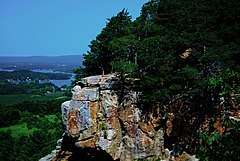
The natural area is located on the outer part of the Magnesian Escarpment[1]/Black River Escarpment,[7] with the soil for the area being glaciated sandy loams, which sit on top of the Galena-Platteville dolomite cap and St. Peter sandstone.[1] Inside the natural area is a 200-foot-tall (61 m) flat-topped butte called "Gibraltar Rock."[1][8] It sits 1,246 feet (380 m) above sea level and is the highest point in Columbia Country.[3] There is a 0.75-mile-long (1.2 km) trail leading up to the Rock.[3]
Wildlife and fauna
Cliff goldenrod, columbine, ferns, pale corydalis and red cedar, little blue-stem, side oats grama, prairie drop-seed, blue-eyed grass, bird's foot violet, bergamot, pasque flower, leadplant, aster, whorled milkweed, and prairie smoke are located within the natural area.[1]
References
- 1 2 3 4 5 6 7 8 "Gibraltar Rock (No. 73)". Wisconsin State Natural Areas Program. Retrieved 28 October 2012.
- ↑ "Gibraltar Rock State Natural Area". Geographic Names Information System. United States Geological Survey.
- 1 2 3 4 5 6 7 8 9 AP; Lyn Jerde (June 6, 2008). Associated Press News Service, ed. "Wisconsin Weekend Package, ADV07-08, WI". Portage Daily Register.
- 1 2 3 4 5 6 7 8 Kevin Revolinski (28 May 2008). 60 Hikes Within 60 Miles: Madison: Including Dane and Surrounding Counties. Menasha Ridge Press. pp. xvii, 92–95. ISBN 978-0-89732-794-7.
- ↑ Wisconsin Department of Transportation, Columbia County, Wisconsin map
- ↑ "Gibraltar Rock County Park". Geographic Names Information System. United States Geological Survey.
- ↑ Wisconsin Natural Resources. Wisconsin Department of Natural Resources. 2005.
- ↑ "Gibraltar Rock (pillar)". Geographic Names Information System. United States Geological Survey.