Caesar Creek State Park
| Caesar Creek State Park | |
| Ohio State Park | |
 | |
| Country | United States |
|---|---|
| State | Ohio |
| Counties | Greene, Warren |
| Elevation | 843 ft (257 m) [1] |
| Coordinates | 39°29′30″N 84°02′21″W / 39.49167°N 84.03917°WCoordinates: 39°29′30″N 84°02′21″W / 39.49167°N 84.03917°W [1] |
| Area | 3,741 acres (1,514 ha) [2] |
| - Water | 2,830 acres (1,145 ha) [3] |
| Established | 1978 |
| Management | Ohio Department of Natural Resources |
 Location in Ohio | |
| Website: Caesar Creek State Park | |
| Caesar Creek Lake | |
|---|---|
 | |
| Location | Warren / Clinton counties, Ohio, United States |
| Coordinates | 39°29′07″N 84°03′55″W / 39.48528°N 84.06528°W |
| Lake type | Reservoir |
| Primary inflows | Caesar Creek |
| Primary outflows | Caesar Creek |
| Basin countries | United States |
| Surface area | 2,830 acres (1,150 ha) |
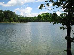
Caesar Creek State Park is located in southwestern Ohio, five miles (8 km) east of Waynesville, in Warren, Clinton, and Greene counties.[2] The park is leased by the State from the U.S. Army Corps of Engineers, who in the 1970s erected a dam on Caesar Creek to impound a 2,830-acre (1,150 ha) lake.[4] The total park area, including the lake, is 7,941-acre (3,214 ha). The park has 43 miles (69 km) of hiking trails and 31 miles (50 km) of bridle trails.
The Army Corps site states:
- Congress authorized Caesar Creek Lake under the Flood Control Act of 1938. The Louisville District of the U.S. Army Corps of Engineers designed, built, and operates Caesar Creek Lake.
- During the fall and winter months, the lake level is lowered to prepare for the storage of heavy spring rainfall. If heavy rains occur, surface water runoff is stored in the lake until the swollen streams and rivers below the dam have receded. Once they can handle the discharge of the stored water without damage to lives or property, the extra water is released.
The dam is an earth and rock fill dam 165 feet (50 m) high and 2,750 feet (840 m) long. The Army Corps site is an area of 10,550 acres (4,270 ha). The watershed above the dam has an area of 237 square miles (61,000 ha). Construction started in 1971 and was finished in 1978.
The site is in the Warren County townships of Massie and Wayne.
Flooding of New Burlington
The construction of the Caesar Creek Lake flooded the small farming village of New Burlington, Ohio in 1973. The history of the community was collected through stories, letters, and journals in the book New Burlington: The Life and Death of an American Village by John Baskin.
Amenities
- Caesar's Creek Pioneer Village - a collection of over 15 log cabins and other structures that are open during special events. The village is maintained and operated by a private non-profit organization. The buildings include a Quaker meetinghouse, a broom shed, a pioneer school house, blacksmith shop, carpenter shop, toll house and many family houses.[3]
- Caesar Creek Nature Center - Adjacent to the Pioneer Village, the nature center features exhibits on the area's cultural and natural history. Nature education programs are offered year round, including campouts, hikes and a maple syrup program.[3]
Sources
- John Baskin. New Burlington: The Life and Death of an American Village. New York: W. W. Norton, 1976. ISBN 0-393-08366-7
- Ohio. Department of Natural Resources. Division of Geological Survey. Excursion to Caesar Creek State Park in Warren County, Ohio. By Douglas L. Shrake. Geological Survey Guidebook No. 12. Columbus, Ohio: The Department, 1992
- United States Department of Agriculture. Natural Resources Conservation Service. Caesar Creek Watershed, Miami Valley Resource Conservation and Development Area : Clinton, Greene, and Warren Counties, Ohio. Fort Worth, Texas: The Service, 1995.
- United States. Department of the Army. Corps of Engineers. Louisville District. Final Updated Environmental Impact Statement: Caesar Creek Lake Project, Ohio. Louisville, Kentucky: The Corps, 1974.
- Art Weber. Ohio State Parks. Saginaw, Michigan: Glovebox Guidebooks, 1995. ISBN 1-881139-04-2.
References
- 1 2 "Caesar Creek State Park". Geographic Names Information System. United States Geological Survey.
- 1 2 "Caesar Creek State Park". Ohio Department of Natural Resources. Retrieved November 13, 2017.
- 1 2 3 "Caesar Creek State Park: Activities". Ohio Department of Natural Resources. Retrieved November 13, 2017.
- ↑ "Caesar Creek State Park: History". Ohio Department of Natural Resources. Retrieved November 13, 2017.
External links
| Wikimedia Commons has media related to Caesar Creek Lake. |
| Wikivoyage has a travel guide for Ohio State Parks that includes Caesar Creek State Park. |
- Caesar Creek State Park Nature Center Association of Caesar Creek
- Caesar Creek State Park Ohio Department of Natural Resources
- Caesar Creek State Park Map Ohio Department of Natural Resources
- Caesar Creek Lake ODNR Division of Wildlife
- Caesar Creek Gorge State Nature Preserve ODNR Division of Natural Areas and Preserves
- Caesar Creek Lake Louisville District, U.S. Army Corps of Engineers