Kelleys Island State Park
| Kelleys Island State Park | |
| Ohio State Park | |
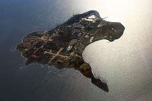 Kelleys Island from the air, looking west | |
| Country | United States |
|---|---|
| State | Ohio |
| County | Erie |
| Elevation | 581 ft (177 m) [1] |
| Coordinates | 41°36′51″N 82°42′19″W / 41.61417°N 82.70528°WCoordinates: 41°36′51″N 82°42′19″W / 41.61417°N 82.70528°W [1] |
| Area | 676 acres (274 ha) [2] |
| Established | 1956 [3] |
| Management | Ohio Department of Natural Resources |
 Location in Ohio | |
| Website: Kelleys Island State Park | |
Kelleys Island State Park is a 676-acre (274 ha) Ohio, United States, state park established in 1956[3] that makes up almost all of the northern third of Kelleys Island in Lake Erie. The park offers 6 miles (9.7 km) of hiking, ruins of lime kilns and quarrying operations, a sand beach and a campground.[4] The park cooperates with other agencies to manage the adjoining Glacial Grooves State Memorial, a set of rare glacial grooves, North Shore Alvar State Natural Area, a rare alvar habitat, and the North Pond Nature Preserve, a lake embayment usually separated from the lake by a sand bar.
References
- 1 2 "Kelleys Island State Park". Geographic Names Information System. United States Geological Survey.
- ↑ "Kelleys Island State Park". Ohio Department of Natural Resources. Retrieved November 15, 2017.
- 1 2 "Kelleys Island State Park: History". Ohio Department of Natural Resources. Retrieved November 15, 2017.
- ↑ "Kelleys Island State Park: Activities". Ohio Department of Natural Resources. Retrieved November 15, 2017.
External links
- Kelleys Island State Park Ohio Department of Natural Resources
- Kelleys Island State Park Map Ohio Department of Natural Resources
| Wikimedia Commons has media related to Kelleys Island. |
| Wikivoyage has a travel guide for Ohio State Parks that includes Kelleys Island State Park. |
This article is issued from
Wikipedia.
The text is licensed under Creative Commons - Attribution - Sharealike.
Additional terms may apply for the media files.