Greenville Creek
| Greenville Creek | |
|---|---|
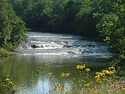 Greenville Falls | |
| Physical characteristics | |
| Main source |
Near Spartanburg, Indiana ~ 1,155 ft (352 m)[1] |
| River mouth |
Stillwater River near Covington, Ohio ~ 875 ft (267 m)[2] |
| Basin features | |
| Basin size | 200 sq mi (520 km2)[3] |
Greenville Creek is a 44.4-mile-long (71.5 km)[4] tributary of the Stillwater River in southwestern Ohio in the United States. Via the Stillwater River, the Great Miami River, and the Ohio River, its water flows to the Mississippi River and ultimately the Gulf of Mexico. The creek starts in extreme eastern Indiana in Randolph County. It soon flows into Darke County, Ohio, and joins with a tributary that also starts in Indiana, Dismal Creek. It flows through Greenville and Gettysburg before entering Miami County. Near its confluence with the Stillwater River at Covington it drops 20 feet (6.1 m) at Greenville Falls in a glacially-cut gorge that is a state nature preserve.[5]
See also
References
- ↑ U.S. Geological Survey. Spartanburg quadrangle, Indiana. 1:24,000. 7.5 Minute Series. Washington D.C.: USGS, 1983.
- ↑ U.S. Geological Survey. Pleasant Hill quadrangle, Ohio. 1:24,000. 7.5 Minute Series. Washington D.C.: USGS, 1983.
- ↑ "Map of Ohio watersheds". Archived from the original on 2007-03-11.
- ↑ U.S. Geological Survey. National Hydrography Dataset high-resolution flowline data. The National Map Archived 2012-04-05 at WebCite, accessed May 19, 2011
- ↑ "Greenville Falls Nature Preserve".
Coordinates: 40°07′06″N 84°21′26″W / 40.11833°N 84.35722°W
This article is issued from
Wikipedia.
The text is licensed under Creative Commons - Attribution - Sharealike.
Additional terms may apply for the media files.