Budapest Metro
%2C_K%C3%A1lvin_t%C3%A9r.jpg)
| UNESCO World Heritage site | |
|---|---|
 Siemens-Halske, Budapest metro museum | |
| Official name | Andrássy Avenue and the Underground |
| Location | Budapest, Hungary |
| Part of | Budapest, including the Banks of the Danube, the Buda Castle Quarter and Andrássy Avenue |
| Criteria | Cultural: (ii), (iv) |
| Reference | 400bis-002 |
| Inscription | 1987 (11th Session) |
| Extensions | 2002 |
| Area | 57.85 ha (0.2234 sq mi) |
| Buffer zone | 239.61 ha (0.9251 sq mi) |
| Website | https://www.bkv.hu/ |
| Coordinates | 47°29′19″N 19°5′13″E / 47.48861°N 19.08694°E |
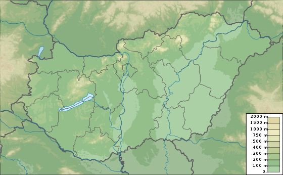 Location of Budapest Metro in Hungary 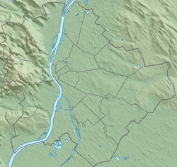 Budapest Metro (Budapest) | |
The Budapest Metro (Hungarian: Budapesti metró) is the rapid transit system in the Hungarian capital Budapest. It is the oldest electrified underground railway system on the European continent, and the third-oldest electrically operated underground railway in the world, predated by the 1890 City & South London Railway (now part of the London Underground) and the Liverpool Overhead Railway in 1893-96.[6][7] Its iconic Line 1 was completed in 1896.[8][9]
History
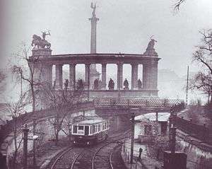

The first metro line was conceived as a means of carrying passengers from the city centre to the City Park without the need for surface transport on Andrássy Avenue. The Diet of Hungary approved the metro project in 1870. Construction began in 1894 and was carried out by the German firm Siemens & Halske AG.
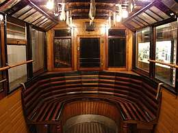
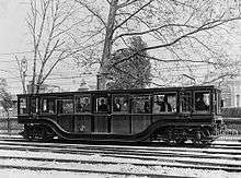
This original metro line followed a northeast-southwest route along Andrássy Avenue from Vörösmarty Square, in the centre of the city, to the City Park and Zoo (Széchenyi fürdõ), a distance of 3.7 kilometres (2.3 mi).[10] There were a total of eleven stations on the line, with nine underground and two above-ground; the original terminus at the Zoo has since been supplanted (by Mexikói út station, further to the northeast, in 1973). With trains running every two minutes, the line was then capable of carrying up to 35,000 passengers per day. One of the original Budapest Metro cars has been preserved at the Seashore Trolley Museum in the United States.[11] Original carriages can also be seen in the Underground Railway Museum at Deák Ferenc tér station[12]
The second line was originally scheduled for completion in 1955, but construction was put on hold for financial and political reasons from 1954 to 1963. Line 2 was built with help of Soviet specialists and finally opened with seven stations on April 4, 1970. It follows an east-west route, connecting the major Keleti (Eastern) and Déli (Southern) railway stations. It has a joint station with the original line at Deák Ferenc Square.
The first line underwent a thorough refurbishment between 1970 and 1973, which included replacement of its rolling stock and a switch from left-hand drive to right-hand drive for the sake of consistency. In 1973, both lines were extended—the first with one station and the second with four. The lines reached their current lengths of 4.4 kilometres (2.7 mi) and 10.3 kilometres (6.4 mi), respectively. The Budapest Transport Company (BKV) took over operation of the metro that same year.
Planning for Line 3 began in 1963 and construction started in 1970 with help of Soviet specialists. The first section, consisting of six stations, opened in 1976. It was extended to the south in 1980 with five additional stations, and to the north in 1981, 1984, and 1990, with nine additional stations. With a length of approximately 16 kilometres (9.9 mi) and a total of 20 stations, it is the longest line in Budapest.
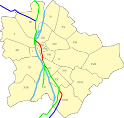
Concurrently with the opening of Line 3, the metro adopted a colour-coding scheme for easier identification. The first line was given the colour yellow, the second line red, and the third, blue. Additionally, green is used to mark the suburban railways (HÉV) in and around Budapest.
In the 1980s and 1990s, Line 1 underwent major reconstruction. Of its 11 stations, eight are original and three were added during reconstruction. The original appearance of the old stations has been preserved, and each station feature displays of historical photographs and information. There is also a Millennium Underground Museum in the Deák Ferenc Square concourse.
Line 4 has a long history, dating back to 1972. In the planning phase, difficulties arose from the medicinal springs (for example, the Gellért Baths) around its planned route. There was a long debate over whether its construction would be safe, what part should be funded by the government and the capital, whether it could be paid for from the Russian state debt towards Hungary, whether the route and length were appropriate, and whether a connector line (see M5 below) would be a better use of funds. When the Line 4 was finished in 2014, its planning and construction spanned 42 years, longer than any other Budapest metro line. Line 4 operates fully automatic and there are no drivers on the trains.
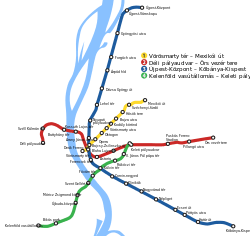
Routes
The Metro consists of four lines, each designated by a number and a colour. Line 1 runs northeast from the Pest city center to City Park along Andrássy Avenue. Line 2 runs generally east to west from the transit hub Örs vezér tere on the city's east side, and provides a connection between Keleti pályaudvar and Déli pályaudvar through the city center. Line 3 runs northwest from the transit hub Kőbánya-Kispest in the city's southeast, along Üllői út to the city center, and then north to the district of Újpest. Line 4 runs southwest to northeast from the transit hub of Budapest Kelenföld vasútállomás in the city's most populous district of Újbuda across the inner city district of Józsefváros to Keleti pályaudvar.
Lines 1–3 converge at Deák Ferenc tér in the city centre, which was long the system's only transfer station. This bottleneck has been remedied by the opening of Line 4, which crosses Line 2 and Line 3 at different stations. The Metro forms a partially separate system from the Budapest HÉV commuter rail, though Line 2 of the Metro provides transfers to the termini of two of the four HÉV lines. Integration of the incompatible HÉV system into the Metro is a long-term goal, and forms the basis of the proposed Line 5.Except for short stretches near the depots of each line, the system is mostly underground.
| Line | Color | Name and Route | Date of first station opening | Most recent station opening | Length (km) | Number of stations | Ride time (end stn. to end stn.) |
|---|---|---|---|---|---|---|---|
| Yellow | Line 1 (Vörösmarty tér ↔ Mexikói út) |
3 May 1896 | 30 December 1973 | 4.4 | 11 | 11 minutes | |
| Red | Line 2 (Déli pályaudvar ↔ Örs vezér tere) |
2 April 1970 | 22 December 1972 | 10.3 | 11 | 18 minutes | |
| Blue | Line 3 (Újpest-Központ ↔ Kőbánya-Kispest) |
31 December 1976 | 14 December 1990 | 17.3 | 20 | 32 minutes | |
| Green | Line 4 (Keleti pályaudvar ↔ Kelenföld vasútállomás) |
28 March 2014 | 7.4 | 10 | 13 minutes | ||
| Total: | 38.6[Note 1] | 52 | |||||
Metro line M1
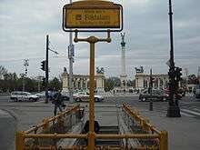
Line 1 runs northeast from the city center on the Pest side under Andrássy út to the Városliget, or City Park. Like Metro 3, it does not serve Buda. Line 1, the oldest of the metro lines operating in Budapest, has been in constant operation since 1896. There are plans for the future for a resurrection with more stations.[13]
Metro line M2
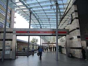
Line 2 runs east-west from Déli pályaudvar in Buda's Krisztinaváros, through the city center, to Örs vezér tere in eastern Pest. It offers connections to Hungarian State Railways at Déli and Keleti pályaudvars, to metro Lines 1 and 3 at Deák Ferenc tér, to line 4 at Keleti pályaudvar, and to suburban railway lines 8 and 9 at Örs vezér tere. Prior to line 4's opening, it was (for more than 45 years) the only metro line that served the Buda side of the river. Line 2 underwent major reconstruction in the late oughts, with all of the track and stations completed in 2008.
Metro line M3

Line 3 runs in a north-south direction (more exactly, from north-northeast to southeast) on the Pest side of the river and connects several populous microraion with the Inner City.[14] It has a transfer station with Line 1 and Line 2 at Deák Ferenc tér, and a transfer station for Line 4 at Kálvin tér. It is the longest line in the Budapest Metro, its daily ridership is estimated at 610,000.[15] From November 2017, BKK begins a resurrection on the line for 3 years, first between Újpest-központ and Lehel tér, than Lehel tér and Kőbánya-Kispest. There are plans for connecting Kőbánya-Kispest and Ferenc Liszt Airport.
Metro line M4
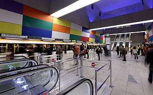
Line 4 runs southwest-northeast from Kelenföldi pályaudvar in Buda's Kelenföld neighborhood to Keleti Railway Station in Józsefváros. With a length of 7.4 kilometres (4.6 mi), it connects to Hungarian State Railways at its termini, to the metro's Line 3 at Kálvin tér, and to Line 2 at Keleti. Line 4 was completed in March 2014 and comprises ten stations.[16]
Metro line M5
The Purple Line 5 is a proposed north-south railway tunnel to connect the currently separated elements of the suburban rail network, namely the H5, H6 and H7 HÉV-lines, and optionally the Budapest-Esztergom and Budapest-Kunszentmiklós-Tass railway lines. Currently the project does not have mainstream political support, only included in long-term plans. The first phase (planned until 2030)[17] would be the extension and connection of the southern H6 and H7 lines to the Astoria metro station via the Kálvin tér, thus connecting these lines to the metro lines M2 M3 and M4. The second phase would create a connection to the metro line M1 as well at the Oktogon, the M3 at Lehel tér then cross the Danube to the Buda side to connect the H5 HÉV towards Szentendre.
In 2017, the plans got brought up again. However, even with permissions, construction can begin in 2019.
General information
Tickets and transfer system
The implementation of latest generation automated fare collection and e-ticket system with NFC compatibility and reusable contactless smart cards for making electronic payments in online and offline systems in Budapest is started in 2014, the project is implemented and operated by the operator of Hong Kong Octopus card jointly with one of the leading European companies of e-ticket and automated fare collection, Scheidt & Bachmann.[18] The deployment of 300 new digital contactless ticket vending machine mainly at the metro stations, will be finished by the end of 2018 in harmonization with the e-ticket system.[19] As of June 2018, only one entrance on the metro network has been equipped with the gates which will be used with the new ticketing system. It is in a limited state, with the gates opening as one approaches. Ticket validators have been installed on a bus and at the terminus of line H6, but are not being used.[20][21][22]
Hours of operation
Lines run from approximately 04:30 to 23:30 every day, though times vary slightly between lines.[23]
Current fleet
The Budapest Metro is completely electrified and standard gauge in operation. Three different types of rolling stock are currently in service:
| Lines | Train-type | Image | Description |
|---|---|---|---|
| Line 1 | Ganz MFAV | 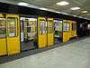 |
3-car articulated-units locally built by Ganz Works. The sets are specifically designed for the unusual loading gauge determined by the shallow tunnel. |
| Line 2 | AM5-M2 | 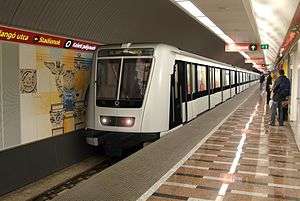 |
Alstom Metropolis, 5-car sets. A trainset is structured as A-B-C-B-A, where the A-B cars are motor cars forming a single electronic unit and coupled semi-permanently, with a C-type trailer car in between the two A-B units. |
| Line 3 | 81-717.2K/714.2K | 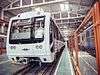 |
Reconstruction of existing Soviet-made 81-717/714 and Ev3 rolling stock (that were prevalent in the former Eastern Bloc). Contract was signed in 2015, all trains to be delivered by June 2018. |
| Line 4 | AM4-M4 |  |
Alstom Metropolis, 4 unit car sets structured as A-B-B-A, where the A-B cars are motor cars forming a single electronic unit and coupled semi-permanently. |
See also
Notes
- ↑ The total length listed here does not match the total given in the Infobox due to difference in how the line lengths are calculated, and the references used. In general, it is assumed that the figure given in the Infobox is the more accurate figure for the system's total route length.
References
- ↑ Mátyás Jangel (September 2010). "Közszolgáltatási szerződés, utasjogok, a szolgáltatástervezés és ellenőrzés folyamata a kötöttpályás helyi- és elővárosi közforgalmú közlekedésben" [Public service contract, passenger rights, service planning and monitoring process of local and suburban public transport rail] (in Hungarian). BKV Zrt. Közlekedési Igazgatóság [Directorate of Public Office. Transport]. pp. 10 (and 3). Archived from the original (pdf) on 2015-01-28. Retrieved 2015-04-19. Metro usage per day – Line 1: 120,000; Line 2: 405,000; Line 3: 630,000. (Line 4 began operations in 2014, with a 110,000 ridership estimated by Centre for Budapest Transport (BKK) based on the latest year.)
- ↑ "Magyarország, 2017" [Hungary, 2017] (pdf) (in Hungarian). Központi Statisztikai Hivatal [Central Statistics Bureau]. 2018-04-15. p. 173. Retrieved 2018-08-01.
- ↑ "Annual Report 2011" (pdf). BKV Zrt. 2011. p. 48. Retrieved 2013-10-06.
- ↑ "New Surface Transport Network Following Start of Metro Line 4 on 29 March 2014". bkk.hu. 28 March 2014. Retrieved 2014-03-30.
- ↑ Siemens.com Budapest Line 4
- ↑ Electric Railway Society (2003). https://books.google.com/books?id=9DdeAAAAIAAJ&redir_esc=y. Doppler Press. p. 61. Retrieved 29 August 2012.
- ↑ . Kogan Page: Europe Review 2003/2004, fifth edition, Wolden Publishing Ltd, 2003, page 174
- ↑ UNESCO Archived January 17, 2010, at WebCite
- ↑ "Our thematic route with... - Sightseeing along the line of Millennium Underground Railway". BKV Zrt. Retrieved 2013-10-18.
- ↑ "Budapest". UrbanRail.net. Retrieved 2014-05-30.
- ↑ "Budapest Metro 18". Seashore Trolley Museum website. Seashore Trolley Museum. Retrieved 2017-03-18.
- ↑ https://www.budapestbylocals.com/budapest-museums.html
- ↑ "M1-es metró korszerűsítése és meghosszabbítása - Budapesti Közlekedési Központ". Budapesti Közlekedési Központ (in Hungarian). Retrieved 2017-10-01.
- ↑ Budapest City Atlas, Dimap-Szarvas, Budapest, 2011, ISBN 978-963-03-9124-5
- ↑ Metro4 - How does it work?
- ↑ "Automated metro Line M4 opens in Budapest". Railway Gazette. 28 March 2014. Retrieved 9 April 2015.
- ↑ Balázs Mór plan, long term service development plans of the BKK
- ↑ "Budapest signed the Contract Agreement for the Automated Fare Collection system". BKK Zrt. 8 October 2014. Retrieved 24 October 2014.
- ↑ "Purchase your ticket easier". BKK Zrt. 17 July 2014. Retrieved 24 October 2014.
- ↑ Gábor, Tenczer (2017-01-19). "2018-ra csúszott a BKK e-jegyrendszerének indulása" (in Hungarian). Retrieved 2018-06-21.
- ↑ "IHO - Közút - Lassan felszáll a RIGO". iho.hu. Retrieved 2018-06-21.
- ↑ "IHO - Vasút - Rigó szállt a Közvágóhídra". iho.hu. Retrieved 2018-06-21.
- ↑ Timetables
External links
| Wikimedia Commons has media related to Metro (Budapest). |
- Budapest Metro Map on Google earth with geolocation
- BKK Zrt. – official website
- Budapest Metro Track map
- Budapest at UrbanRail.net
- Budapest Metro Map
| Landmarks |
|  | ||||||||||||||||||||||||
|---|---|---|---|---|---|---|---|---|---|---|---|---|---|---|---|---|---|---|---|---|---|---|---|---|---|---|
| Districts |
| |||||||||||||||||||||||||
| Events and traditions | ||||||||||||||||||||||||||
| Universities |
| |||||||||||||||||||||||||
| Economy | ||||||||||||||||||||||||||
| Transport | ||||||||||||||||||||||||||
| ||||||||||||||||||||||||||
 | ||