Óbuda-Békásmegyer
| 3rd District of Budapest Budapest III. kerülete Óbuda-Békásmegyer | |||
|---|---|---|---|
| District of Budapest | |||
| District III | |||
| |||
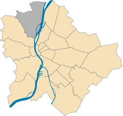 Location of District III in Budapest (shown in grey) | |||
| Coordinates: 47°34′03″N 19°02′13″E / 47.5674°N 19.0370°E | |||
| Country | Hungary | ||
| Region | Central Hungary | ||
| City | Budapest | ||
| Established | 17 November 1873 | ||
| Quarters[1] |
List
| ||
| Government | |||
| • Mayor | Balázs Bús (Fidesz-KDNP) | ||
| Area[2] | |||
| • Total | 39.7 km2 (15.3 sq mi) | ||
| Area rank | 3rd | ||
| Population (2016)[2] | |||
| • Total | 130,415 | ||
| • Rank | 2nd | ||
| • Density | 3,285/km2 (8,510/sq mi) | ||
| Demonym(s) | harmadik kerületi (“3rd districter”) | ||
| Time zone | UTC+1 (CET) | ||
| • Summer (DST) | UTC+2 (CEST) | ||
| Postal code | 1031 ... 1039 | ||
| Website |
obuda | ||


Óbuda-Békásmegyer is the 3rd district of Budapest, Hungary.
See also
References
- ↑ "94/2012. (XII. 27.) Főv. Kgy. rendelet - a közterület- és városrésznevek megállapításáról, azok jelöléséről, valamint a házszám-megállapítás szabályairól" (in Hungarian).
- 1 2 "A fővárosi kerületek, a megyei jogú városok, a városok területe, lakónépessége és a lakások száma" [The area of districts of the capital, of the towns with county's rights, resident population and number of dwellings]. Magyarország közigazgatási helynévkönyve 2016. január 1 [Gazetteer of Hungary 1st January, 2016] (PDF). Hungarian Central Statistical Office. 2016. p. 21.
External links
| Wikimedia Commons has media related to Budapest District III. |
|  | |
This article is issued from
Wikipedia.
The text is licensed under Creative Commons - Attribution - Sharealike.
Additional terms may apply for the media files.