Várkerület
| 1st District of Budapest Budapest I. kerülete Várkerület | |||
|---|---|---|---|
| District of Budapest | |||
| District I | |||
| |||
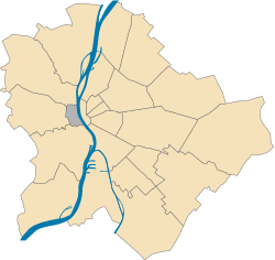 Location of District I in Budapest (shown in grey) | |||
| Coordinates: 47°29′51″N 19°02′17″E / 47.49750°N 19.03806°E | |||
| Country | Hungary | ||
| Region | Central Hungary | ||
| City | Budapest | ||
| Established | 17 November 1873 | ||
| Quarters[1] |
List
| ||
| Government | |||
| • Mayor | Gábor Tamás Nagy (Fidesz-KDNP) | ||
| Area[2] | |||
| • Total | 3.41 km2 (1.32 sq mi) | ||
| Area rank | 20th | ||
| Population (2016)[2] | |||
| • Total | 25,196 | ||
| • Rank | 22nd | ||
| • Density | 7,388/km2 (19,130/sq mi) | ||
| Demonym(s) | első kerületi (“1st districter”) | ||
| Time zone | UTC+1 (CET) | ||
| • Summer (DST) | UTC+2 (CEST) | ||
| Postal code | 1011 ... 1016 | ||
| Website |
www | ||


Várkerület (Castle District) is the historical part of the Buda side of Budapest and consists of the Buda Castle Hill and some other neighbourhoods around it, like Tabán, Krisztinaváros and parts of Gellért Hill.
Location
The Castle District is situated on the banks of the Danube, in the Buda side.
Neighbours of District I are (clockwise from north):
- River Danube
- District XI: Újbuda ("New Buda"), which is most known of the universities and student life
- District XII: Hegyvidék ("Highlands")
- District II
Landmarks
Twin towns
References
- ↑ "94/2012. (XII. 27.) Főv. Kgy. rendelet a közterület- és városrésznevek megállapításáról, azok jelöléséről, valamint a házszám-megállapítás szabályairól" (in Hungarian).
- 1 2 "A fővárosi kerületek, a megyei jogú városok, a városok területe, lakónépessége és a lakások száma" [The area of districts of the capital, of the towns with county's rights, resident population and number of dwellings]. Magyarország közigazgatási helynévkönyve 2016. január 1 [Gazetteer of Hungary 1st January, 2016] (PDF). Hungarian Central Statistical Office. 2016. p. 21.
- ↑ "Testvérvárosaink" (in Hungarian). Budavári Önkormányzat. Retrieved 2012-10-24.
External links

|  | |
This article is issued from
Wikipedia.
The text is licensed under Creative Commons - Attribution - Sharealike.
Additional terms may apply for the media files.