List of Budapest Metro stations

This is a list of the 48 stations of the Budapest Metro, which operates in Budapest, Hungary, including the dates of opening (and closure). Termini and interchange stations are in bold and bold italics, respectively. Stations with the access icon (![]()
Lines
| Line | Color | Route | Length | Stations | Opened |
|---|---|---|---|---|---|
| Yellow | Vörösmarty tér ↔ Mexikói út | 4.4 km (3 mi)[1][2] | 11 | 1896 | |
| Red | Déli pályaudvar ↔ Örs vezér tere | 10.3 km (6 mi)[1][3][4] | 11 | 1970 | |
| Blue | Újpest-Központ ↔ Kőbánya-Kispest | 16.5 km (10 mi)[5] | 20 | 1976 | |
| Green | Kelenföld vasútállomás ↔ Keleti pályaudvar | 7.4 km (5 mi)[6] | 10 | 2014 | |
| TOTAL | 38.6 km (24 mi) | 52 | |||
Stations
M1 Line (Millennium Underground)
- Vörösmarty tér (formerly: Gizella tér) 1896
- Deák Ferenc tér 1896 (rebuilt in 1955)
- Bajcsy-Zsilinszky út (formerly: Váczy körút) 1896
- Opera 1896
- Oktogon (formerly: November Hetedike tér) 1896
- Vörösmarty utca 1896
- Kodály körönd (formerly: Körönd) 1896
- Bajza utca 1896
- Hősök tere (formerly: Aréna út) 1896
- Állatkert 1896 (closed: 1973)
- Széchenyi fürdő (formerly overground station: 1896–1973; underground station: 1973)
- Mexikói út 1973
M2 Line (East-West line)
Built in 1970, extended in 1972. It is usually marked red. According to schedule, it runs along in 18 minutes.
- Örs vezér tere (formerly: Fehér út) 1970

- Pillangó utca 1970
- Puskás Ferenc Stadion (formerly: Stadionok and Népstadion) 1970
- Keleti pályaudvar 1970
- Blaha Lujza tér 1970
- Astoria 1970
- Deák Ferenc tér 1970
- Kossuth Lajos tér (formerly: Kossuth tér) 1972
- Batthyány tér 1972
- Széll Kálmán tér (formerly: Moszkva tér) 1972
- Déli pályaudvar 1972
M3 Line (North-South line)
First section in 1976, then expansions in 1980, 1981, 1984 and 1990. It is usually marked blue. According to schedule, it runs along in 31 minutes.
- Kőbánya-Kispest 1980
- Határ út 1980
- Pöttyös utca 1980
- Ecseri út 1980
- Népliget 1980
- Nagyvárad tér 1976
- Klinikák 1976
- Corvin-negyed (formerly: Ferenc körút) 1976
- Kálvin tér 1976
- Ferenciek tere (formerly: Felszabadulás tér) 1976
- Deák Ferenc tér 1976
- Arany János utca 1981
- Nyugati pályaudvar (formerly: Marx tér) 1981
- Lehel tér (formerly: Élmunkás tér) 1981
- Dózsa György út 1984
- Árpád híd 1984
- Forgách utca 1990
- Gyöngyösi utca 1990
- Újpest-Városkapu 1990
- Újpest-Központ 1990
There is a planned extension towards Káposztásmegyer to the northeast and Budapest Ferihegy International Airport to the southeast.
M4 Line (Northeast-Southwest)
Line M4 had been originally scheduled to be built by around 2005, but, as there were numerous political debates over it, not to mention a number of civilian protests against the building of the tunnel for the line at certain parts of the city, building has only started in 2005 and the completion date had been re-scheduled to 2012 or 2013. The line has been opened to the public at noon 28 March 2014.
- Madárhegy ? (planned)
- Gazdagrét ? (planned)
- Kelenföld vasútállomás 2014
- Bikás park 2014
- Újbuda–központ 2014
- Móricz Zsigmond körtér 2014
- Szent Gellért tér 2014
- Fővám tér 2014
- Kálvin tér 2014
- Rákóczi tér 2014
- II. János Pál pápa tér 2014
- Keleti pályaudvar 2014
- Dózsa György út (not identical with the M3 station; name may change) ? (planned)
- Hungária körút ? (planned)
- Róna utca ? (planned)
- Bosnyák tér ? (planned)
Note: Dózsa György út is also the name of an existing underground station of M3, so it will probably be renamed.
There are plans to extend the line towards Újpalota in the east, and towards Budaörs in the west.
Planned future stations
M5 Line (North-South)
Line 5 | ||||||||||||||||||||||||||||||||||||||||||||||||||||||||||||||||||||||||||||||||||||||||||||||||||||||||||||||||||||||||||||||||||||||||||||||||||||||||||||||||||||||||||||||||||||||||||||||||||||||||||||||||||||||||||||||||||||||||||||||||||||||||||||||||||||||||||||||||||||||||||||||||||||||||||||||||||||||||||||||||||||||||||||||||||||||||||||||||||||||||||||||||||||||||||||||||||||||||
|---|---|---|---|---|---|---|---|---|---|---|---|---|---|---|---|---|---|---|---|---|---|---|---|---|---|---|---|---|---|---|---|---|---|---|---|---|---|---|---|---|---|---|---|---|---|---|---|---|---|---|---|---|---|---|---|---|---|---|---|---|---|---|---|---|---|---|---|---|---|---|---|---|---|---|---|---|---|---|---|---|---|---|---|---|---|---|---|---|---|---|---|---|---|---|---|---|---|---|---|---|---|---|---|---|---|---|---|---|---|---|---|---|---|---|---|---|---|---|---|---|---|---|---|---|---|---|---|---|---|---|---|---|---|---|---|---|---|---|---|---|---|---|---|---|---|---|---|---|---|---|---|---|---|---|---|---|---|---|---|---|---|---|---|---|---|---|---|---|---|---|---|---|---|---|---|---|---|---|---|---|---|---|---|---|---|---|---|---|---|---|---|---|---|---|---|---|---|---|---|---|---|---|---|---|---|---|---|---|---|---|---|---|---|---|---|---|---|---|---|---|---|---|---|---|---|---|---|---|---|---|---|---|---|---|---|---|---|---|---|---|---|---|---|---|---|---|---|---|---|---|---|---|---|---|---|---|---|---|---|---|---|---|---|---|---|---|---|---|---|---|---|---|---|---|---|---|---|---|---|---|---|---|---|---|---|---|---|---|---|---|---|---|---|---|---|---|---|---|---|---|---|---|---|---|---|---|---|---|---|---|---|---|---|---|---|---|---|---|---|---|---|---|---|---|---|---|---|---|---|---|---|---|---|---|---|---|---|---|---|---|---|---|---|---|---|---|---|---|---|---|---|---|---|---|---|---|---|---|---|---|---|---|---|---|---|---|---|---|---|---|---|---|---|---|---|---|---|---|---|---|---|---|---|---|---|---|---|---|---|---|---|---|
| ||||||||||||||||||||||||||||||||||||||||||||||||||||||||||||||||||||||||||||||||||||||||||||||||||||||||||||||||||||||||||||||||||||||||||||||||||||||||||||||||||||||||||||||||||||||||||||||||||||||||||||||||||||||||||||||||||||||||||||||||||||||||||||||||||||||||||||||||||||||||||||||||||||||||||||||||||||||||||||||||||||||||||||||||||||||||||||||||||||||||||||||||||||||||||||||||||||||||
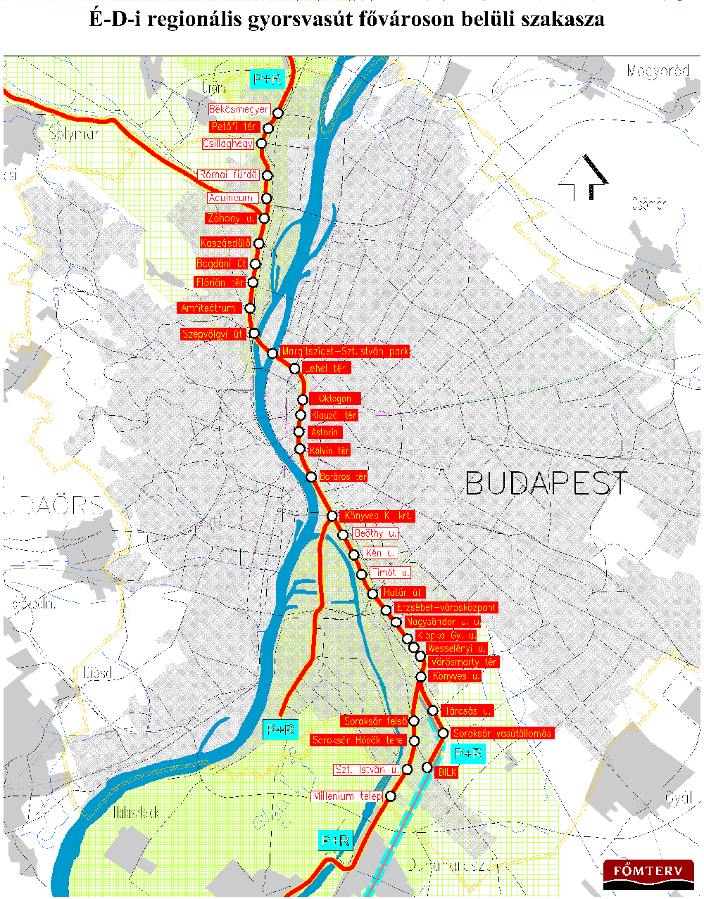
Metro line 5, Észak-déli Regionális Gyorsvasút (North-South Regional Rapid Railway; provisional name), is planned to be a suburban railways' connector line, meant to replace and connect the lines of the existing suburban railways between Szentendre (currently served by HÉV Line 5), Ráckeve (currently served by HÉV Line 6) and Csepel (currently served by HÉV Line 7). It will cross Budapest downtown, and provide connection for the railway stations in the city. It will probably have the following stations (except for the termini, only those within Budapest are included):
- Szentendre
- ...
- Békásmegyer
- Petőfi tér
- Csillaghegy
- Rómaifürdő
- Aquincum
- Záhony u.
- Kaszásdűlő
- Bogdáni út
- Flórián tér
- Amfiteátrum
- Szépvölgyi út
- Margitsziget
- Szent István park
- Lehel tér
- Oktogon
- Klauzál tér
- Astoria
- Kálvin tér
- Boráros tér
- Könyves Kálmán körút
- Beöthy u.
- Kén u.
- Timót u.
- Határ út
- Pesterzsébet – városközpont
- Nagysándor József u.
- Klapka Gy. u.
- Wesselényi u. (or Akácfa u. instead of the latter two)
- Vörösmarty tér
- Könyves u.
- Tárcsás u.
- Soroksári vasútállomás
- BILK (logisztikai központ)
- ...
- Csepel, Ráckeve
Branching at Könyves u.:
- Soroksár felső
- Soroksár – Hősök tere
- Szent István u.
- Millennium-telep
- ...
See the map.[7]
See also
References
- 1 2 Mátyás Jangel (September 2010). "Közszolgáltatási szerződés, utasjogok, a szolgáltatástervezés és ellenőrzés folyamata a kötöttpályás helyi- és elővárosi közforgalmú közlekedésben" [Public service contract, passenger rights, service planning and monitoring process of local and suburban public transport rail] (in Hungarian). BKV Zrt. Közlekedési Igazgatóság [Directorate of Public Office. Transport]. pp. 10 (and 3). Archived from the original (pdf) on 28 January 2015. Retrieved 19 April 2015.
- ↑ "Az M1 Millenniumi Földalatti..." (pdf) (in Hungarian). Budapesti Közlekedési Központ. 2012. p. 6. Retrieved 2014-04-02.
- ↑ "2-es metróvonal jellemzői" (in Hungarian). Retrieved 2014-04-02.
- ↑ Árpád Bodnár: A budapesti metró két évtizede ("Two decades of the Budapest Metro"), Városi Közlekedés, Year XXXI, Vol. 3, pp. 119-121, Budapest, 1991
- ↑ András Koós - Tamás Szirmay - Jenő Tiborcz: A budapesti 3-as metróvonal új szakasza ("The new section of Budapest Metro Line 3"), Városi Közlekedés, Year XXXI, Vol. 1, pp. 126-127, Budapest, 1991.
- ↑ "New Surface Transport Network Following Start of Metro Line 4 on 29 March 2014". bkk.hu. 28 March 2014. Retrieved 2014-03-30.
- ↑ https://img.index.hu/cikkepek/0503/belfold/metr5/metro5-bp.gif
External links
 | ||