Brookland (Washington, D.C.)
| Brookland | |
|---|---|
| Neighborhood of Washington, D.C. | |
 Brookland within the District of Columbia | |
| Coordinates: 38°55′39″N 76°59′24″W / 38.9275°N 76.99°WCoordinates: 38°55′39″N 76°59′24″W / 38.9275°N 76.99°W | |
| Country | United States |
| District | Washington, D.C. |
| Ward | Ward 5 |
| Government | |
| • Councilmember | Kenyan McDuffie |
Brookland is a neighborhood in the Northeast quadrant of Washington, D.C., historically centered along 12th Street NE. Brookland is in the Upper Northeast area element[1] and is bounded by Otis Street to 14th Street to Taylor Street NE to the north, Rhode Island Avenue NE to the south, South Dakota Avenue NE to the east, and 9th Street NE to the west [2]. The western boundary originates with the establishment of the former Metropolitan Branch of the Baltimore and Ohio Railroad in 1873,[3] which now incorporates the Red Line of the Washington Metro creating the physical barrier which continues to separate Brookland from Edgewood to the west today.
Brookland is served by the Brookland–CUA station on the Red Line of the Washington Metro.
Landmarks
- Fort Bunker Hill
- Newton Theater
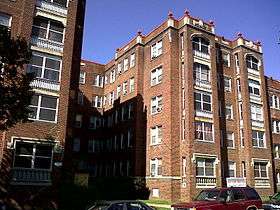
- Dahlgreen Courts
- Brooks Mansion
- Charles Richard Drew Memorial Bridge
- Quincy House
- Robert C. Weaver House
- John P. Davis House
- Ralph Bunche House
- Rayford Logan House
- Sterling Brown House
- Lucy Diggs Slowe House
- Marjorie Kinnan Rawlings House
- Lois Mailou Jones House
- The Round House
- King David Masonic Lodge
- St. Anthony's Catholic School & Church
History

In 1632 the English successfully claimed the land from the Algonquin-speaking Indians who inhabited the region and King Charles I of England in turn granted the land, which was to become the state of Maryland, to George Calvert, whose interest in the colony lay in "the sacred duty of finding a refuge for his Roman Catholic brethren."[4]
Colonel Jehiel Brooks married into the land when he married Ann Margaret Queen, daughter of Nicholas Queen, and they received a 150-acre estate.[5]
For most of the 19th century the area was farmland owned by the prominent Middleton and Queen families. The Baltimore and Ohio Railroad later connected this portion of Washington County to downtown. Bellair, the 1840 brick Greek Revival mansion built by Colonel Jehiel Brooks, still stands. It is referred to as Brooks Mansion. It is the site of offices and production facilities for the Public Access Corporation of the District of Columbia, the city's Government-access television (GAVT) channel known as DCTV.
Change came rapidly during and after the American Civil War. First, Fort Slemmer and Fort Bunker Hill were constructed as defenses against the Confederate Army, and later the Old soldiers' home was constructed to the northwest. The population of the city itself increased with the expansion of the federal government, and the former Brooks family estate became a housing tract named "Brookland."
Growth continued throughout the 1870s when the Baltimore and Ohio Railroad opened its Western Branch Line in the developing Brookland neighborhood.[6] With the construction of nearby Sherwood, University Heights, and other tracts, and the expansion of Washington's streetcars, a middle-class streetcar suburb developed, and eventually its expansion southward met Washington's northward. Many Queen Anne style and other Victorian homes still stand.
The transition from a country estate towards a residential development beginning in 1887 "marked the extension of suburban growth into the rather isolated reaches of the northeastern sector" of D.C.[7] In its early days, the Brookland community was marked by "spacious lots and single family homes" which appealed to middle-class families and provided a "small town atmosphere.[7]"
Catholic institutions
Brookland, together with its surrounding neighborhoods, has been at times referred to as "Little Rome" because of the many Catholic organizations and institutions clustered around The Catholic University of America (CUA),[8]. The university itself does not lie within Brookland's borders, but since the Catholic Church purchased the Middletown estate, adjacent to Brookland, in 1887, many groups have established themselves there and in the neighboring communities of University Heights, Edgewood and Michigan Park, including the following:
- Archbishop Carroll High School, 1951
- Basilica of the National Shrine of the Immaculate Conception, 1920
- Dominican House of Studies, 1905
- Franciscan Monastery of the Holy Land in America (Mount St. Sepulchre Franciscan Monastery), 1905
- Holy Name College, 1931–1984[9]
- Holy Redeemer College
- Little Sisters of the Poor Jeanne Jugan Residence, 1982[10]
- Missionary Oblates of Mary Immaculate USA headquarters
- Monastery of the Holy Cross[11]
- Poor Clares of Perpetual Adoration convent, 1954–2017[12]
- Pope John Paul II Cultural Center, 2001; later Saint John Paul II National Shrine
- Quincy House
- St. Francis Hall, 1931
- Saint John Paul II Seminary, 2011[13]
- St. Josaphat Ukrainian Catholic Seminary, 1941[14]
- St. Joseph’s Seminary, 1930[15]
- St. Paul's College, 1914
- Scrilli School and Carmelite convent
- Sisters of Notre Dame de Namur convent
- Trinity Washington University, 1897
- Ukrainian Catholic National Shrine of the Holy Family, 1979
- Washington Retreat House of the Franciscan Sisters of the Atonement, 1930[16]
Since 1984, the Franciscans’ Holy Name College has served as the Howard University School of Divinity’s East Campus.[17]
Community diversity
While mostly Caucasian at its founding, Brookland integrated in the 20th century, especially after white flight took place following World War II. Although there was some hostility directed at early black integration of the neighborhood, by the middle of the century Brookland had developed into a neighborhood fairly integrated among economic classes and races. During the mid-twentieth century, Brookland could boast of such prominent residents as Ralph Bunche, Sterling Brown, Edward Brooke, Ellis O. Knox, Rayford W. Logan, and Pearl Bailey, John P. Davis, Marvin Gaye, Paul Tsongas, Stacey Latisaw, Lucy Diggs Slowe and Robert C. Weaver. It remains a relatively diverse and stable area of Washington. African American architect Romulus C. Archer designed homes, buildings, and churches in the area..[18]
Brookland was also home to the playwright Jean Kerr and her playwright/critic husband Walter Kerr who taught at nearby CUA. The writer Marjorie Kinnan Rawlings spent her childhood in Brookland.
Justine Ward, the music educator and author, lived in Brookland and built the large residence now occupied by Ronald McDonald House in the 1300 block of Quincy Street. CUA's School of Music is named in her honor. Also on Quincy Street is the Quincy House, a long-time residence of Catholic graduate students who regularly host coffee houses and other community events.
Businesses
Brookland Hardware anchored 12th Street NE for many years until it closed in November 2015. However, many full-service restaurants still make the thoroughfare a bustling corridor. These include Smith Public Trust, Brookland's Finest, Menomale, Steel Plate, San Antonio Grill, Askale Cafe, and Murray and Paul's, which is only open for breakfast. New additions in 2016 included Pho12 and Salumeria Italiana, an Italian deli from the owners of Menomale. Additionally, there are also a few carry out restaurants including Today's Pizza, Pizza Boli's, Sammy Carry-Out, and New Tong-Shing. Other businesses found along the street include Yes! Organic Market, Openbox9 Graphic Design Studio, along with realtors, auto-mechanics, nail and hair salons, florists, liquors stores and District Veterinary Hospital opened by local veterinarian Dr. Dan Teich. While not on 12th Street, Right Proper Brewery's Production House & Tasting Room is also located in the neighborhood.
In November 2011, D.C. based real estate developer Abdo broke ground on a large mixed-use development spread over a previously underutilized 8.9 acre plot.[19] The project, known as Monroe Street Market, was fully completed in 2014. Despite the word "BROOKLAND" prominently painted on the main building, the entire complex lies within neighboring Edgewood.[20][21] This area includes 27 artists' studios on an "Arts Walk," a Barnes & Noble (CUA's bookstore), a Potbelly Sandwich Works, a Chipotle Mexican Grill, a Starbucks, and local chain Busboys and Poets. While there are new projects slated for 2017/2018, at least part of the community believes the area is being overly developed, which has led to a few court battles with developers.[22]
References
- ↑ https://planning.dc.gov/node/605372
- ↑ http://opendata.dc.gov/datasets/neighborhood-clusters?geometry=-77.728%2C38.813%2C-76.311%2C39
- ↑ "The Metropolitan Railroad" (PDF). The Evening Star. Washington, D.C. April 30, 1873. p. 4.
- ↑ "America as a Religious Refuge: The Seventeenth Century, Part 2 - Religion and the Founding of the American Republic | Exhibitions (Library of Congress)". www.loc.gov. Retrieved 2015-09-16.
- ↑ McDaniel, George W.; Pearce, John N.; Aurand, Martin, eds. (1988). Images of Brookland: The History and Architecture of a Washington Suburb. Washington, D.C.: Center for Washington Area Studies, George Washington University. p. 7. OCLC 8973194.
- ↑ Brookland Neighborhood Finding Aid, Special Collections Research Center, Estelle and Melvin Gelman Library, The George Washington University
- 1 2 McDaniel, George W.; Pearce, John N.; Aurand, Martin, eds. (1988). Images of Brookland: The History and Architecture of a Washington Suburb. Washington, D.C.: Center for Washington Area Studies, George Washington University. p. 3. OCLC 8973194.
- ↑ "Debates Over Development In D.C.'s "Little Rome"". The Kojo Nnamdi Show. October 13, 2016. Retrieved 5 January 2017.
- ↑ Anderson, Jeffrey (February 2, 2016), "The Catholic Church Is Selling Northeast DC to Developers", [[Washingtonian (magazine)|]], retrieved August 31, 2016
- ↑ History, Little Sisters of the Poor Jeanne Jugan Residence, retrieved August 31, 2018
- ↑ Monastery of the Holy Cross, Archeparchy of Philadelphia, Ukrainian Catholic Church, retrieved August 31, 2018
- ↑ Seegers, Kelly (June 29, 2017), "Poor Clares of Perpetual Adoration close Washington monastery, trusting in God's providence", Catholic Standard, retrieved August 31, 2018
- ↑ "The Founding and Center of the Saint John Paul II Seminary", Seek First the Kingdom, Archdiocese of Washington, April 29, 2018, retrieved August 31, 2018
- ↑ History, St. Josaphat Ukrainian Catholic Seminary, retrieved August 31, 2018
- ↑ Giambrone, Andrew (August 17, 2016), "More Than 80 Townhouses Planned Near St. Joseph's Seminary in Northeast", Washington City Paper, retrieved August 31, 2018
- ↑ Washington Retreat House, Franciscan Sisters of the Atonement, Graymoor, retrieved August 31, 2018
- ↑ Anderson, Jeffrey (February 2, 2016). "The Catholic Church Is Selling Northeast DC to Developers". The Washingtonian. Retrieved 5 January 2017.
- ↑ "Archer, Romulus Cornelius, Jr. (1890 - 1968) -- Philadelphia Architects and Buildings". www.philadelphiabuildings.org.
- ↑ Paul, Shilpi (November 9, 2011). "Brookland's Monroe Street Market Breaks Ground". Urban Turf. Retrieved 5 January 2017.
- ↑ https://goo.gl/maps/HfNB5TmHQsv Edgewood Map
- ↑ http://www.popville.com/2016/07/edgewood-getting-into-the-branding-game/ Popville (07/08/16)
- ↑ Alpert, David (June 2, 2016). "A court ruling on a Brookland development could imperil future housing near Metro stations". Greater Greater Washington. Retrieved 5 January 2017.
External links
| Wikivoyage has a travel guide for Brookland. |
| Wikimedia Commons has media related to Brookland, Washington, D.C.. |
- Brookland Neighborhood Civic Association
- BygoneBrookland (Brookland History)
- 2011 Washington Post article on Brookland
- The Brooks - Queen Family Collection (1773-1979) documents the activities of members of the two families who built the Brooks Mansion.
- Door to Door interview with author of Images of America: Brookland
- Map of Brookland in 1903
Places adjacent to Brookland (Washington, D.C.) | |
|---|---|