Near Northeast, Washington, D.C.
| Near Northeast | |
|---|---|
| Neighborhood of Washington, D.C. | |
| Nickname(s): H Street Corridor | |
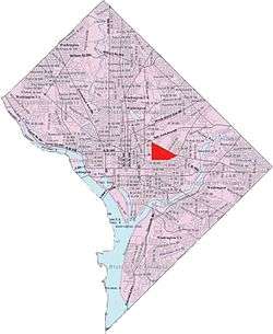 Map of Washington, D.C., with Near Northeast highlighted in red | |
| Country | United States |
| District | Washington, D.C. |
| Ward | Ward 6 |
| Government | |
| • Councilmember | Charles Allen |
| Website | http://hstreet.org |
Near Northeast is a neighborhood in Northeast Washington, D.C. It is bounded by North Capitol Street to the west, Florida Avenue to the north, F Street to the south, and 15th Street to the east.
History

Once a patchwork of several different landowners' claims, most of the land had been ceded to one landowner, Notley Young, under the name of Youngsborough by the 1790s. Youngsborough was included shortly thereafter in the original survey of land for the new national capital, and Young and a few other landowners gave the land to the Federal government in exchange for a promise that Congress would divide the land into lots and return half of those lots to the original landowners.
Once the capital was created, streets were laid out in the grid system that Pierre L'Enfant had designed, with Boundary Street (now known as Florida Avenue) forming the northern border of the city. However, nearly all of the land remained undeveloped, used as farmland to cultivate fruits and vegetables for the fresh market in the more developed sections of the city. The land lots that were used for non-agricultural purposes in the early 19th century were mostly cemeteries.
19th Century
In the 1830s, the B&O Railroad constructed its Washington Branch, which entered the city of Washington at roughly 9th and Boundary Streets and proceeded through the neighborhood to the downtown area. Its presence gradually led Old City to evolve into a working-class neighborhood: wood and coal yards appeared to serve the railroad and its terminals, with houses subsequently built for the employees of the railroad industries.
The neighborhood remained undeveloped and sparsely populated through the end of the 19th century, although by the 1890s, H Street NE was the eastern terminus of the Washington streetcar system (at 15th Street). Some minor commercial development, therefore, began to develop along H Street.
The area was also the site of Swampoodle Grounds, a baseball stadium which was the home of the Washington Nationals baseball club from 1886 to 1889, when the team folded.
20th century
Near Northeast evolved into mixed neighborhood. It was a major center of black population in the first half of the 20th century as well as a significant neighborhood for immigrant populations from Ireland, Germany, Greece, Italy and Eastern Europe. Union Station's construction destroyed the poor Irish neighborhood known as Swampoodle, buried Tiber Creek and allowed for development to increase. Today, Near Northeast sides on the Eastern part of the now non-existent Swampoodle.[1]
A number of important institutions developing in the area:
- 1897: The Northeast Temple and Market, an indoor marketplace and Lodge temple. The first buildings electrified on H Street NE.
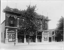
- 1913: the Apollo Theater at 624-634 H Street NE.[2]
- 1941: Uline Arena at 1132, 1140 and 1146 3rd Street NE.
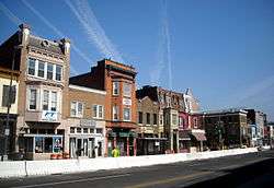
During this same period, a twelve-block strip of H Street (from 3rd Street to 15th) became one of the most important shopping corridors in Washington. It catered primarily to a working-class clientele, but was densely commercial, with restaurants, theaters, banks, grocery stores, clothing stores, and Ourisman Chevrolet, one of the most prominent car dealerships in the city. It was the location of the very first Sears Roebuck store in Washington. In addition, two of the most recognizable and popular locations were the whites-only Moderne style Atlas Theater at 1331 H Street and its black counterpart, the Plymouth Theater, down the block at 1365 H Street. Like the theaters, most of the businesses in the H Street corridor (and elsewhere in Old City) were strictly segregated, but some businesses (an unusual number of which were black-owned) catered to both black and white customers. By 1950, however, approximately 50 percent of the residents of Old City/Near Northeast were African American.
The emerging Civil Rights Movement touched off a decline in the H Street corridor and other commercial areas of Near Northeast; the upscale downtown businesses, taking advantage of the ambitions of the movement, began specifically targeting an integrated clientele and even a predominantly black one. This meant that even the growing black population of Old City/Near Northeast began patronizing the prestigious department stores of downtown Washington, and the neighborhood businesses suffered as a result.
The neighborhood was devastated by the race riot that ripped Washington for the three days following Martin Luther King, Jr.'s assassination in April 1968. Order was restored with the assistance of the US military brought in to assist the DC Police. Looting, vandalism, and arson made Near Northeast one of the worst casualties of the riots, with many burned-out or otherwise destroyed properties burned out for decades. Most white residents moved out of the neighborhood to Maryland and Virginia. The neighborhood became a poor black neighborhood with few resources until its revitalization.[3]
Present day
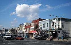
H Street, so long the center of the neighborhood's life, is being structured as an arts district. Theaters, jazz clubs, performance spaces, and exotic restaurants are appearing in the neighborhood. In 2005 and 2006, a substantial number of venues and bars opened in the H Street corridor, including the Argonaut, Sidamo, Showbar Presents the Palace of Wonders, the Red and the Black,[4] Rock & Roll Hotel,[5] and Little Miss Whiskey's Golden Dollar, among others. Business owners in that area are calling the area the Atlas District,[6] after the movie theater (now a dance and performance studio) that has been its most prominent landmark for half a century.
A new wave of residents has rapidly changed the area with sit-down restaurants, hip bars, more upscale retail establishments. The older residents note that this process has also made the neighborhood feel safer with more affluent residents investing in the community. This is a return to a more diverse community as it was before the 1968 riots when most white residents left.[7]
Neighborhood landmarks
The Uline Arena, more popularly known as Washington Coliseum, has long been an important anchor of the community. It was the site of the first Beatles concert in the United States on February 11, 1964, and also hosted the Washington Lions of the old Eastern Hockey League; speeches by Elijah Muhammad and Malcolm X; and pro-American rallies during World War II. The building still stands; as of 2017 is now an REI.[8]
Of the many movie theaters in Old City/Near Northeast, two of the most prominent still stand on H Street, although both are now used for different purposes. One, the old Moderne style Atlas Theater, has been renovated Atlas Performing Arts Center,[9] as a center for dance and the performing arts. Its neighbor, the Plymouth Theater, for a time named the H Street Playhouse,[10] was the home of the theatrical company called the Theater Alliance.[11] The Apollo Theater was demolished in the 1950s but lives on in the "Apollo" building that now stands in its place.[12]
Nomenclature
The neighborhood has taken on a variety of unofficial nicknames, most with little success.
Realtors tried to introduce the portmanteau "SoFlo" (a combination of "South of Florida Avenue"), hoping to attract an affluent, younger demographic. Residents and realtors tried to introduce the term "Capitol Hill North", hoping to benefit from the higher market values of properties directly to the south on Capitol Hill.[13]
Businessmen responsible for the economic revitalization of the western section tried to introduce the term "Atlas District", a reference to the Atlas Theater. Residents have been slow to embrace any of these terms and instead identify themselves as "living in Northeast", "living off H Street", or "from Near Northeast".
Recent resurgence[14] of the term "Swampoodle", referring to a vague Western boundary to the triangle, has supported the informal term "FSHNET", referencing the three bounds: Florida, Swampoodle, H street North East Triangle.
Infrastructure
Near Northeast is served by two stations on the Red Line of the Washington Metro: Union Station and the NoMa – Gallaudet University station which was renamed in June 2012 from the name New York Ave–Florida Ave–Gallaudet University Metro station. Since both of these metro stations are on the western side of the neighborhood, several bus lines bring commuters to the above stations.
A modern streetcar runs from the back of Union Station down to Benning Road since February 27, 2016. It is the first in Washington, DC since the previous system was dismantled in 1962.[15]
As part of the city's Sustainability Plan,[16] DDOT has also added several bikes lanes running east to west on G Street NE and I Street NE as well as north to south on 4th Street NE and 6th Street NE. Multiple Capital Bikeshare stations have also been added in several key areas of the neighborhood.
Administration
Near Northeast is located in entirely in Ward 6 and represented locally by a Council Member.
Its citizens are represented by two Advisory Neighborhood Commissions depending on their location:
- ANC6C: western part Union Station to 8th Street NE
- ANC6A: eastern part from 8th Street NE to Starburst Plaza
References
- ↑ Department of Transportation Headquarters: Environmental Impact Statement, GSA June 2000
- ↑ "Building Permits", The Evening Star, April 2, 1913
- ↑ "Growth of H Street: Where people used to 'run,' now they stay". WTOP.com. August 15, 2017. Retrieved January 10, 2018.
- ↑ "Red and Black Bar - Como Ganhar Dinheiro na Internet". Red and Black Bar. Retrieved January 10, 2018.
- ↑ "Rock and Roll Hotel DC". Rock & Roll Hotel. Retrieved January 10, 2018.
- ↑ "Atlas District". Atlas-District.com. Retrieved January 10, 2018.
- ↑ Schultz, David (March 6, 2012). "On H Street, gentrification not as simple as black and white". Retrieved January 10, 2018 – via www.WashingtonPost.com.
- ↑ iStrategyLabs. "Uline Arena - Douglas Development". DouglasDevelopment.com. Retrieved January 10, 2018.
- ↑ "Atlas Performing Arts Center - Atlas Performing Arts Center - Washington DC". www.AtlasArts.org. Retrieved January 10, 2018.
- ↑ "Casino online aams - Casinò on line legali italiani". www.HStreetPlayhouse.com. Retrieved January 10, 2018.
- ↑ Goldstein, Jessica (July 30, 2012). "H Street Playhouse moving to Anacostia". Retrieved January 10, 2018 – via www.WashingtonPost.com.
- ↑ "The Apollo - The Show Lives on at H Street". www.TheApolloDC.com. Retrieved January 10, 2018.
- ↑ "Drawing the Line: Capitol Hill". UrbanTurf.com. Retrieved January 10, 2018.
- ↑ "NoMa Parks Foundation Announces "Swampoodle Park" as Name for New Park | NoMa Parks Foundation". www.nomaparks.org. Retrieved 2018-02-05.
- ↑ Laris, Michael (February 27, 2016). "D.C. streetcar makes its first voyages on H Street. 'Is it really happening?'". Washington Post. Retrieved 2016-02-27.
- ↑ "sustainable - Sustainable DC". Sustainable.DC.gov. Retrieved January 10, 2018.
External links
| Wikimedia Commons has media related to Near Northeast, Washington, D.C.. |
| Wikivoyage has a travel guide for Near Northeast, Washington, D.C.. |
- Advisory Neighborhood Commissions 6A and 6C, respectively covering the eastern and western halves of Near Northeast, consider a wide range of policies and programs affecting the local neighborhoods, including traffic, parking, recreation, street improvements, liquor licenses, zoning, economic development, police protection, sanitation and trash collection, and the District's annual budget.
- H Street DC - A guide to the neighborhood's major commercial corridor
Places adjacent to Near Northeast, Washington, D.C. | ||||||||||
|---|---|---|---|---|---|---|---|---|---|---|
| ||||||||||