Woodridge, Washington, D.C.
| Woodridge | |
|---|---|
| Neighborhood of Washington, D.C. | |
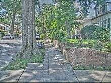
 Woodridge is a primarily residential neighborhood. | |
 Woodridge within the District of Columbia | |
| Coordinates: 38°55′53″N 76°58′16″W / 38.9315°N 76.9711°WCoordinates: 38°55′53″N 76°58′16″W / 38.9315°N 76.9711°W | |
| Country | United States |
| District | Washington, D.C. |
| Ward | Ward 5 |
| Government | |
| • Councilmember | Kenyan McDuffie |
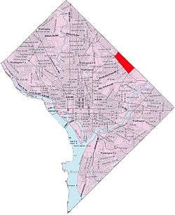
Woodridge is a residential neighborhood located in Ward 5 of Northeast Washington, D.C.. Woodridge is contained between Eastern Avenue to the east, Michigan Avenue NE to the north, South Dakota Avenue NE to the west, and Bladensburg Road NE to the south. Its central commercial strips are Rhode Island Avenue NE (Route 1) and Bladensburg Road NE. Woodridge borders the adjacent neighborhoods of Brookland, Langdon, North Michigan Park, and Fort Lincoln in the District of Columbia. In addition to these neighborhoods in the District of Columbia, Woodridge also borders the city of Mount Rainier and town of Cottage City in Maryland. In terms of public transportation, residents of Woodridge have access to the Brookland-CUA and Rhode Island Avenue Metro stations as well as Metrobus Service on the Rhode Island Avenue Corridor (Route 1), Bladensburg Road NE, Michigan Avenue NE, 18th Street NE, Eastern Avenue, and South Dakota Avenue NE.
Education
District of Columbia Public Schools operates public schools.
District of Columbia Public Library operates the Woodridge Neighborhood Library located at 18th and Rhode Island Ave. N.E.[1]
References
| Wikimedia Commons has media related to Woodridge, Washington, D.C.. |
- ↑ "Hours & Locations." District of Columbia Public Library. Retrieved on October 21, 2009.