Broderick, Saskatchewan
| Broderick | |
|---|---|
| Village | |
| Village of Broderick | |
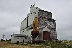 Grain elevators in Broderick | |
 Broderick Location of Broderick in Saskatchewan  Broderick Broderick (Canada) | |
| Coordinates: 51°30′43″N 106°54′43″W / 51.512°N 106.912°WCoordinates: 51°30′43″N 106°54′43″W / 51.512°N 106.912°W | |
| Country | Canada |
| Province | Saskatchewan |
| Region | West-central |
| Census division | 11 |
| Rural municipality | Rudy No. 284 |
| Post office Founded | December 1, 1907 |
| Government | |
| • Type | Municipal |
| • Governing body | Broderick Village Council |
| • Mayor | Arlin Simonson[1] |
| • Administrator | Shannon Pederson[2] |
| • MP | Kelly Block |
| • MLA | Jim Reiter |
| Area | |
| • Total | 0.91 km2 (0.35 sq mi) |
| Population (2016) | |
| • Total | 85 |
| • Density | 93.9/km2 (243/sq mi) |
| Time zone | UTC-6 (CST) |
| Postal code | S0H 0L0 |
| Area code(s) | 306 |
| Highways |
|
| Railways | Canadian Pacific Railway (abandoned) |
| [3][4][5][6] | |
Broderick is a village within the Rural Municipality of Rudy No. 284, Saskatchewan, Canada. The village had a population of 85 in the 2016 Census, (a 19.7% increase from in the 2011 Census). The village is approximately 5 km (3.1 mi) east of the town of Outlook. The post office was originally established under the name Chromar on December 1, 1907, but its name was changed to Broderick on January 1, 1909.[7]
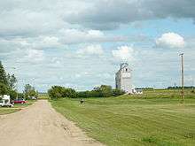
Looking down Railway Avenue towards the former Saskatchewan Wheat Pool elevator
Demographics
| Canada census – Broderick, Saskatchewan community profile | |||
|---|---|---|---|
| 2016 | 2011 | 2006 | |
| Population: | 85 (+ 19.7% from 2011) | 71 (-7.8% from 2006) | 77 (-7.2% from 2001) |
| Land area: | 0.91 km2 (0.35 sq mi) | 0.91 km2 (0.35 sq mi) | 0.91 km2 (0.35 sq mi) |
| Population density: | 93.9/km2 (243/sq mi) | 78.4/km2 (203/sq mi) | 85.0/km2 (220/sq mi) |
| Median age: | 37.0 (M: 41.5, F: 30.5) | 47.4 (M: 49.0, F: 46.8) | 39.5 (M: 38.5, F: 41.2) |
| Total private dwellings: | 37 | 38 | 37 |
| Median household income: | $Not Available | $Not Available | |
| References: 2016[8] 2011[9] 2006[10] earlier[11] | |||
See also
References
- ↑ Municipal Directory System
- ↑ Municipal Directory System
- ↑ National Archives, Archivia Net, Post Offices and Postmasters, archived from the original on 2006-10-06
- ↑ Government of Saskatchewan, MRD Home. "Municipal Directory System". Archived from the original on 15 January 2016. Retrieved 6 September 2009.
- ↑ Canadian Textiles Institute. (2005), CTI Determine your provincial constituency, archived from the original on 2007-09-11
- ↑ Commissioner of Canada Elections, Chief Electoral Officer of Canada (2005), Elections Canada On-line, archived from the original on 2007-04-21
- ↑ National Archives, Archivia Net, Post Offices and Postmasters, archived from the original on 2006-10-06
- ↑ "2016 Community Profiles". Canada 2016 Census. Statistics Canada. February 21, 2017. Retrieved 2017-03-15.
- ↑ "2011 Community Profiles". Canada 2011 Census. Statistics Canada. July 5, 2013. Retrieved 2012-11-12.
- ↑ "2006 Community Profiles". Canada 2006 Census. Statistics Canada. March 30, 2011. Retrieved 2009-02-24.
- ↑ "2001 Community Profiles". Canada 2001 Census. Statistics Canada. February 17, 2012.
External links

Places adjacent to Broderick, Saskatchewan | |
|---|---|
| Subdivisions | |
|---|---|
| Communities | |
| Cities | |
| Topics |
|
| |

This article is issued from
Wikipedia.
The text is licensed under Creative Commons - Attribution - Sharealike.
Additional terms may apply for the media files.