Viscount, Saskatchewan
| Viscount | |
|---|---|
| Village | |
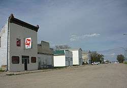 Amherst Avenue | |
| Motto(s): "A warm welcoming community" | |
 Viscount  Viscount | |
| Coordinates: 51°57′0″N 105°39′0″W / 51.95000°N 105.65000°WCoordinates: 51°57′0″N 105°39′0″W / 51.95000°N 105.65000°W | |
| Country | Canada |
| Province | Saskatchewan |
| Rural Municipalities (R.M.) | Viscount No. 341, Saskatchewan |
| Post office Founded | 1908-01-01 |
| Government | |
| • Mayor | Moe Kirzinger |
| Area | |
| • Total | 1.18 km2 (0.46 sq mi) |
| Elevation | 548 m (1,798 ft) |
| Population (2011) | |
| • Total | 252 |
| • Density | 212.7/km2 (551/sq mi) |
| [1] | |
| Postal code | S0K 4M0 |
| Area code(s) | 306 |
| Website | Official website |
| [2][3][4][5] | |
Viscount is a village in the rural municipality of Viscount No. 341, Saskatchewan, in the Canadian province of Saskatchewan. Viscount is located on Saskatchewan Highway 16, the Yellowhead in central Saskatchewan east of Colonsay and west of Lanigan.[6]
Viscount post office first opened in 1908 in the Dominion Land Survey Sec.29, Twp.34, R.26, W2.
Demographics
| Canada census – Viscount, Saskatchewan community profile | |||
|---|---|---|---|
| 2006 | |||
| Population: | 252 (-7.7% from 2001) | ||
| Land area: | 1.18 km2 (0.46 sq mi) | ||
| Population density: | 211.9/km2 (549/sq mi) | ||
| Median age: | N/A (M: N/A, F: N/A) | ||
| Total private dwellings: | 130 | ||
| Median household income: | $N/A | ||
| References: 2006[7] earlier[8] | |||
Climate
| Climate data for Viscount | |||||||||||||
|---|---|---|---|---|---|---|---|---|---|---|---|---|---|
| Month | Jan | Feb | Mar | Apr | May | Jun | Jul | Aug | Sep | Oct | Nov | Dec | Year |
| Record high °C (°F) | 6.5 (43.7) |
9.5 (49.1) |
19.5 (67.1) |
30 (86) |
37 (99) |
40.5 (104.9) |
37.5 (99.5) |
36.5 (97.7) |
33 (91) |
28.5 (83.3) |
18.9 (66) |
8.5 (47.3) |
40.5 (104.9) |
| Average high °C (°F) | −11.7 (10.9) |
−8.3 (17.1) |
−0.7 (30.7) |
10.6 (51.1) |
18.6 (65.5) |
22.8 (73) |
24.9 (76.8) |
24.2 (75.6) |
17.8 (64) |
10.2 (50.4) |
−2.3 (27.9) |
−9.9 (14.2) |
8 (46) |
| Daily mean °C (°F) | −16.8 (1.8) |
−13.3 (8.1) |
−5.6 (21.9) |
4.4 (39.9) |
11.6 (52.9) |
16.1 (61) |
18.1 (64.6) |
17.1 (62.8) |
11.2 (52.2) |
4.2 (39.6) |
−6.7 (19.9) |
−14.7 (5.5) |
2.1 (35.8) |
| Average low °C (°F) | −21.8 (−7.2) |
−18.2 (−0.8) |
−10.5 (13.1) |
−1.9 (28.6) |
4.5 (40.1) |
9.4 (48.9) |
11.3 (52.3) |
9.9 (49.8) |
4.6 (40.3) |
−1.8 (28.8) |
−11.1 (12) |
−19.4 (−2.9) |
−3.8 (25.2) |
| Record low °C (°F) | −40.5 (−40.9) |
−41.5 (−42.7) |
−35 (−31) |
−26.7 (−16.1) |
−10 (14) |
−1 (30) |
3.5 (38.3) |
−3 (27) |
−8 (18) |
−23.5 (−10.3) |
−35 (−31) |
−42 (−44) |
−42 (−44) |
| Average precipitation mm (inches) | 16.7 (0.657) |
12.2 (0.48) |
20.3 (0.799) |
26.5 (1.043) |
54.6 (2.15) |
71.1 (2.799) |
61.5 (2.421) |
51.2 (2.016) |
38.8 (1.528) |
23.8 (0.937) |
14.3 (0.563) |
20.7 (0.815) |
411.6 (16.205) |
| Source: Environment Canada[9] | |||||||||||||
See also
References
- ↑ "2011 Community Profiles". Statistics Canada. Government of Canada. Retrieved 2014-08-21.
- ↑ National Archives, Archivia Net. "Post Offices and Postmasters". Retrieved 2014-08-21.
- ↑ Government of Saskatchewan, MRD Home. "Municipal Directory System". Retrieved 2014-08-21.
- ↑ Canadian Textiles Institute. (2005), CTI Determine your provincial constituency, archived from the original on 2007-09-11
- ↑ Commissioner of Canada Elections, Chief Electoral Officer of Canada (2005), Elections Canada On-line
- ↑ Adamson, J, Rand McNally 1924 Saskatchewan Map, retrieved 2008-03-26
- ↑ "2006 Community Profiles". Canada 2006 Census. Statistics Canada. March 30, 2011. Retrieved 2009-02-24.
- ↑ "2001 Community Profiles". Canada 2001 Census. Statistics Canada. February 17, 2012.
- ↑ Environment Canada - Canadian Climate Normals 1971-2000—Canadian Climate Normals 1971–2000, accessed 23 December 2010
External links
Places adjacent to Viscount, Saskatchewan | ||||||||||
|---|---|---|---|---|---|---|---|---|---|---|
| ||||||||||
| Subdivisions | |
|---|---|
| Communities | |
| Cities | |
| Topics |
|
| |
This article is issued from
Wikipedia.
The text is licensed under Creative Commons - Attribution - Sharealike.
Additional terms may apply for the media files.