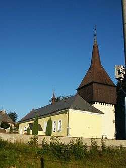
Borová (Svitavy District)
| Borová | |||
|---|---|---|---|
| Municipality | |||
 | |||
| |||
 Borová | |||
| Coordinates: 49°44′26″N 16°9′12″E / 49.74056°N 16.15333°ECoordinates: 49°44′26″N 16°9′12″E / 49.74056°N 16.15333°E | |||
| Country |
| ||
| Region | Pardubice | ||
| District | Svitavy | ||
| Area | |||
| • Total | 12.99 km2 (5.02 sq mi) | ||
| Elevation | 615 m (2,018 ft) | ||
| Population (1.1.2014) | |||
| • Total | 972 | ||
| • Density | 75/km2 (190/sq mi) | ||
| Postal code | 569 82 | ||
| Website | http://www.borova.cz | ||
Borová is a village and municipality (obec) in Svitavy District in the Pardubice Region of the Czech Republic.
The municipality covers an area of 12.99 square kilometres (5.02 sq mi), and has a population of 930 (as at 28 August 2006).
Borová lies approximately 23 kilometres (14 mi) west of Svitavy, 43 km (27 mi) south-east of Pardubice, and 130 km (81 mi) east of Prague.
References
| Wikimedia Commons has media related to Borová (Svitavy District). |
This article is issued from
Wikipedia.
The text is licensed under Creative Commons - Attribution - Sharealike.
Additional terms may apply for the media files.