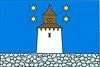
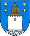
Korouhev (Svitavy District)
| Korouhev | |||
|---|---|---|---|
| Municipality | |||
 | |||
| |||
 Korouhev | |||
| Coordinates: 49°39′46″N 16°15′14″E / 49.66278°N 16.25389°ECoordinates: 49°39′46″N 16°15′14″E / 49.66278°N 16.25389°E | |||
| Country |
| ||
| Region | Pardubice | ||
| District | Svitavy | ||
| Area | |||
| • Total | 17.87 km2 (6.90 sq mi) | ||
| Elevation | 558 m (1,831 ft) | ||
| Population (1.1.2014) | |||
| • Total | 816 | ||
| • Density | 46/km2 (120/sq mi) | ||
| Postal code | 569 93 to 572 01 | ||
| Website | http://www.sweb.cz/obec.korouhev/ | ||
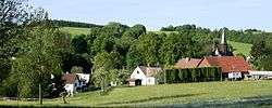
Korouhev is a village and municipality (obec) in Svitavy District in the Pardubice Region of the Czech Republic.
The municipality covers an area of 17.87 square kilometres (6.90 sq mi), and has a population of 757 (as at 28 August 2006).
Korouhev lies approximately 19 kilometres (12 mi) south-west of Svitavy, 54 km (34 mi) south-east of Pardubice, and 140 km (87 mi) east of Prague.
References
This article is issued from
Wikipedia.
The text is licensed under Creative Commons - Attribution - Sharealike.
Additional terms may apply for the media files.