Bladworth
| Bladworth | |
|---|---|
| Village | |
| Village of Bladworth | |
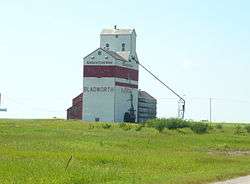 Grain elevator in Bladworth | |
 Bladworth Location of Bladworth in Saskatchewan  Bladworth Bladworth (Canada) | |
| Coordinates: 51°21′58″N 106°08′17″W / 51.366°N 106.138°W | |
| Country | Canada |
| Province | Saskatchewan |
| Region | Central |
| Census division | 11 |
| Rural Municipality | McCraney |
| Government | |
| • Mayor | Ron Bessey |
| • Administrator | Donna Bessey |
| • Governing body | Bladworth Village Council |
| Area | |
| • Total | 0.84 km2 (0.32 sq mi) |
| Population (2011)[1] | |
| • Total | 60 |
| • Density | 71.2/km2 (184/sq mi) |
| Time zone | UTC-6 (CST) |
| Postal code | S0G 0L0 |
| Area code(s) | 306 |
| Highways | Highway 11 |
| [2][3][4] | |
Bladworth (2016 Population 65) is a village within the Rural Municipality of McCraney No. 282, Saskatchewan, Canada. The village is located 99 kilometres (62 mi) south of the city of Saskatoon on Highway 11.
Demographics
| Canada census – Bladworth community profile | |||
|---|---|---|---|
| 2016 | 2011 | 2006 | |
| Population: | 65 (+ 8.3% from 2011) | 60 (-14.3% from 2006) | 70 (4.5% from 2001) |
| Land area: | 0.84 km2 (0.32 sq mi) | 0.84 km2 (0.32 sq mi) | 0.84 km2 (0.32 sq mi) |
| Population density: | 77.2/km2 (200/sq mi) | 71.2/km2 (184/sq mi) | 83.1/km2 (215/sq mi) |
| Median age: | 44.5 (M: 43.7, F: 45.2) | 44.8 (M: 45.5, F: 42.5) | 40.8 (M: 40.5, F: 41.5) |
| Total private dwellings: | 38 | 39 | 32 |
| Median household income: | $Not Available | ||
| References: 2016[5] 2011[6] 2006[7] earlier[8] | |||
Architecture
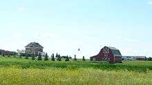
Bladworth is the site of a Saskatchewan Municipal Heritage property, a two-story brick house clearly visible from adjacent Highway 11. The J. Fred Johnston house is named for its builder, a Saskatchewan entrepreneur, Liberal Member of Parliament and later a Senator, from 1943 to 1948.[9] The home is now owned by Barkley and Tannis Prpick, proprietors of the local public house. Mr. Prpick is a noted local figure and third generation "Bladworthian".
See also
Footnotes
- ↑ "2011 Community Profiles". Statistics Canada. Government of Canada. Retrieved 2014-08-21.
- ↑ National Archives, Archivia Net. "Post Offices and Postmasters". Archived from the original on 2006-10-06. Retrieved 2014-08-21.
- ↑ Government of Saskatchewan, MRD Home. "Municipal Directory System". Archived from the original on 2016-01-15. Retrieved 2014-08-21.
- ↑ Commissioner of Canada Elections, Chief Electoral Officer of Canada (2005), Elections Canada On-line, archived from the original on 2007-04-21
- ↑ "2016 Community Profiles". Canada 2016 Census. Statistics Canada. February 21, 2017.
- ↑ "2011 Community Profiles". Canada 2011 Census. Statistics Canada. July 5, 2013. Retrieved 2011-02-24.
- ↑ "2006 Community Profiles". Canada 2006 Census. Statistics Canada. March 30, 2011. Retrieved 2009-02-24.
- ↑ "2001 Community Profiles". Canada 2001 Census. Statistics Canada. February 17, 2012.
- ↑ Canada's Historic Places. "J. Fred Johnston House". Archived from the original on 2014-09-05. Retrieved 2014-08-21.
External links
- Saskatchewan Gen Web - One Room School Project
- Saskatchewan Gen Web Region
- Online Historical Map Digitization Project
- 2006 Community Profiles
Places adjacent to Bladworth | |
|---|---|
| Subdivisions | |
|---|---|
| Communities | |
| Cities | |
| Topics |
|
| |

Coordinates: 51°21′58″N 106°08′17″W / 51.366°N 106.138°W
This article is issued from
Wikipedia.
The text is licensed under Creative Commons - Attribution - Sharealike.
Additional terms may apply for the media files.