Barzalosa Formation
| Barzalosa Formation Stratigraphic range: ~Mid Eocene-Oligocene or Oligocene-Early Miocene ~40–20 Ma | |
|---|---|
| Type | Geological formation |
| Underlies | Honda Gp., Carmen de Apicalá Conglomerate |
| Overlies | La Tabla Fm., Olini Gp., Seca Fm. |
| Thickness | ~360 m (1,180 ft) |
| Lithology | |
| Primary | Conglomerates |
| Other | Sandstones, siltstones, shale, gypsum |
| Location | |
| Coordinates | 4°21′50.2″N 74°47′29.8″W / 4.363944°N 74.791611°WCoordinates: 4°21′50.2″N 74°47′29.8″W / 4.363944°N 74.791611°W |
| Approximate paleocoordinates | 2°42′N 71°12′W / 2.7°N 71.2°W |
| Region |
Upper Magdalena Valley Central & Eastern Ranges Andes |
| Country |
|
| Type section | |
| Named for | Barzalosa |
| Named by | Scheibe |
| Location | Girardot |
| Year defined | 1934 |
| Coordinates | 4°21′50.2″N 74°47′29.8″W / 4.363944°N 74.791611°W |
| Region | Cundinamarca |
| Country |
|
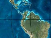 Paleogeography of Northern South America 35 Ma, by Ron Blakey | |
The Barzalosa Formation (Spanish: Formación Barzalosa, Pgb, Pgba) is a fossiliferous geological formation of the Upper Magdalena Valley and the bounding foothills of the Central Ranges and Eastern Ranges of the Colombian Andes. The formation consists of conglomerates, sandstones and siltstones. The Barzalosa Formation probably dates to the Late Paleogene to Early Neogene period; Oligocene to Early Miocene epochs, and has an approximate thickness of 360 metres (1,180 ft). Fossils of Balanerodus logimus, Lophiodolodus chaparralensis, Xenastrapotherium chaparralensis, Protheosodon sp. and Proadinotherium sp. have been uncovered from the formation in Chaparral, Tolima.
Etymology
The formation was defined by Scheibe in 1934 and named after Barzalosa, a vereda of Girardot, Cundinamarca. Cáceres and Etayo elevated the "Pisos de Barzalosa" to a formation in 1969.[1]
Description
Lithologies
The Barzalosa Formation consists of conglomerates, sandstones and siltstones.[2] In parts, the formation contains shale beds and gypsum.[3]
Stratigraphy and depositional environment
The approximately 360 metres (1,180 ft) thick Barzalosa Formation overlies the Olini Group and the Seca Formation in the west and is overlain by the Honda Group.[2] In the east towards Fusagasugá, the formation overlies the La Tabla Formation and is overlain by the Carmen de Apicalá Conglomerate.[4] As the formation does not contain foraminifera, the age is difficult to establish, but has been estimated to be Oligocene to Early Miocene,[2] or Middle Eocene to Oligocene.[5] The depositional environment has been interpreted as alluvial fans and braided rivers.[6]
Fossil content
| Location | Department | Fossils | Notes |
|---|---|---|---|
| Alto San José, Chaparral | Tolima | Balanerodus logimus | |
| Lophiodolodus chaparralensis | |||
| Xenastrapotherium chaparralensis | |||
| Protheosodon sp. | |||
| Proadinotherium sp. | |||
| Megalonychoidae indet., Gavialidae indet. |
Outcrops
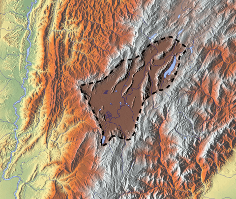
The Barzalosa Formation is apart from its type locality found in Tocaima and to the east of Agua de Dios,[1] and on the western side of the Magdalena River around Chaparral, Tolima.[12]
See also
References
- 1 2 Acosta et al., 2002, p.49
- 1 2 3 Acosta et al., 2002, p.50
- ↑ Acosta & Ulloa, 2001, p.56
- ↑ Acosta & Ulloa, 2001, p.52
- ↑ Acosta & Ulloa, 2001, p.57
- ↑ Acosta et al., 2002, p.51
- ↑ Balanerodus logimus in the Paleobiology Database
- ↑ Lophiodolodus chaparralensis in the Paleobiology Database
- ↑ Xenastrapotherium chaparralensis in the Paleobiology Database
- ↑ Protheosodon in the Paleobiology Database
- ↑ Proadinotherium in the Paleobiology Database
- 1 2 Chaparral Alto José in the Paleobiology Database
Bibliography
- Acosta, Jorge E.; Rafael Guatame; Juan Carlos Caicedo A., and Jorge Ignacio Cárdenas. 2002. Mapa Geológico de Colombia - Plancha 245 - Girardot - 1:100,000 - Memoria Explicativa, 1–92. INGEOMINAS.
- Acosta, Jorge E., and Carlos E. Ulloa. 2001. Mapa Geológico de Colombia - Plancha 246 - Fusagasugá - 1:100,000 - Memoria Explicativa, 1–77. INGEOMINAS.
Maps
- Acosta, Jorge E.; Rafael Guatame; Oscar Torres, and Frank Solano. 1999. Plancha 245 - Girardot - 1:100,000, 1. INGEOMINAS. Accessed 2017-06-06.
- Acosta, Jorge E., and Carlos E. Ulloa. 1998. Plancha 246 - Fusagasugá - 1:100,000, 1. INGEOMINAS. Accessed 2017-06-06.
Paleontology in Colombia | |||||||||||||
|---|---|---|---|---|---|---|---|---|---|---|---|---|---|
| Notable researchers |
|   .jpg)  | |||||||||||
| Major fossiliferous stratigraphic units |
| ||||||||||||
| Notable fossils | |||||||||||||