Barra
| Gaelic name |
|
|---|---|
 | |
| Location | |
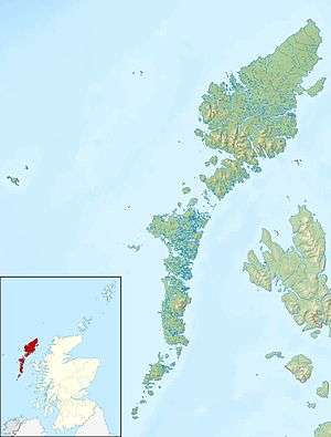 Barra Barra shown within the Outer Hebrides | |
| OS grid reference | NF687004 |
| Coordinates | 56°59′00″N 7°28′00″W / 56.9833°N 7.4667°W |
| Physical geography | |
| Island group | Barra and Vatersay |
| Area | 5,875 hectares (22.7 sq mi) |
| Area rank | 20 [1] |
| Highest elevation | Heaval, 383 metres (1,257 ft) |
| Administration | |
| Sovereign state | United Kingdom |
| Country | Scotland |
| Council area | Na h-Eileanan Siar |
| Demographics | |
| Population | 1,174[2] |
| Population rank | 13 [1] |
| Population density | 19.98 people/km2[2][3] |
| Largest settlement | Castlebay |
| References | [3][4] |
Barra (Scottish Gaelic: Barraigh, Eilean Bharraigh, pronounced [ˈparˠaj, ˈelan ˈvarˠaj]) is an island in the Outer Hebrides, Scotland, and the second southernmost inhabited island there, after the adjacent island of Vatersay to which it is connected by a short causeway. In 2011, the population was 1,174.[2][5]
Gaelic
At the 2011 Census, there were 761 Gaelic speakers (62%).[6]
Geography
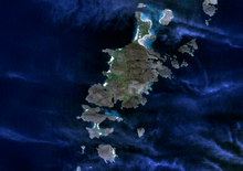
The area of Barra is roughly 60 square kilometres (23 sq mi), 11 miles long and 6 miles wide. The main village is Castlebay (Bàgh a' Chaisteil). A single track road runs around the coast of the island where the flattest land and houses are, the interior of the island is hilly and uninhabited.
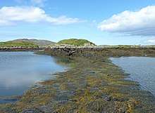
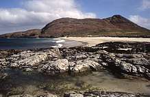
The west of the island has white sandy beaches backed by shell-sand, machair and the east has numerous rocky inlets.
Kisimul Castle at Castlebay is on a rock in the bay, giving the village its name. A smaller medieval tower house, Dun Mhic Leoid, can be found in the middle of Loch St Clare on the west side of the island at Tangasdale.[7]
The highest elevation on the island is Heaval, halfway up which is a prominent white marble statue of the Madonna and Child, called "Our Lady of the Sea", which was erected during the Marian year of 1954. The predominant faith on the island is Catholicism and the Catholic church dedicated to Our Lady of the Sea is immediately apparent to all who arrive at Castlebay.[8]
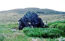
Other places of interest on the island include a ruined church and museum at Cille Bharra, a number of Iron Age brochs such as those at Dùn Chuidhir and An Dùn Bàn, and a range of other Iron Age and later structures which have recently been excavated and recorded.
Barra is connected by a causeway to the smaller island of Vatersay, population 90.
Climate
Barra has an oceanic climate, with mild temperatures year round.
| Climate data for Barra (Traigh Mhòr Airport, averages 1981–2010) | |||||||||||||
|---|---|---|---|---|---|---|---|---|---|---|---|---|---|
| Month | Jan | Feb | Mar | Apr | May | Jun | Jul | Aug | Sep | Oct | Nov | Dec | Year |
| Average high °C (°F) | 8.3 (46.9) |
7.8 (46) |
9.0 (48.2) |
10.5 (50.9) |
12.9 (55.2) |
14.7 (58.5) |
16.3 (61.3) |
16.4 (61.5) |
14.9 (58.8) |
12.4 (54.3) |
10.3 (50.5) |
8.6 (47.5) |
11.9 (53.4) |
| Average low °C (°F) | 4.3 (39.7) |
4.0 (39.2) |
4.5 (40.1) |
5.6 (42.1) |
7.7 (45.9) |
9.7 (49.5) |
11.6 (52.9) |
12.0 (53.6) |
10.7 (51.3) |
8.7 (47.7) |
6.3 (43.3) |
4.6 (40.3) |
7.5 (45.5) |
| Average rainfall mm (inches) | 144.4 (5.685) |
96.0 (3.78) |
111.2 (4.378) |
64.1 (2.524) |
53.8 (2.118) |
62.1 (2.445) |
81.1 (3.193) |
95.4 (3.756) |
101.9 (4.012) |
117.5 (4.626) |
125.1 (4.925) |
119.0 (4.685) |
1,171.4 (46.118) |
| Average rainy days (≥ 1 mm) | 21.4 | 18.2 | 20.7 | 11.8 | 12.0 | 11.1 | 12.8 | 17.2 | 14.6 | 16.6 | 20.0 | 20.7 | 197.1 |
| Mean monthly sunshine hours | 27.4 | 61.3 | 97.6 | 157.0 | 209.6 | 172.6 | 149.7 | 156.8 | 122.6 | 85.5 | 41.4 | 19.5 | 1,300.9 |
| Source: [9] | |||||||||||||
History
Early history
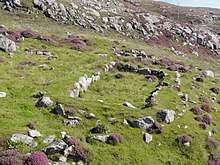
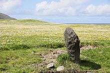
During the construction of a road in the 1990s, the discovery of a near-complete pottery beaker dating from 2500BC established that there has been a human presence on Barra since the neolithic era. As well as pottery, a number of stone remains were found, including a neolithic "work platform", which complement the several standing stones scattered around the island. In the hills to the north of Borve, there is a large chambered cairn, sited in a prominent position.
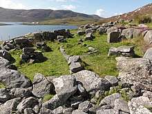
Beyond the main island, a Bronze Age cemetery can be found on Vateray, as well as an Iron Age broch; the remains of a similarly aged broch can be found on the east of Barra itself. Remains of Bronze Age burials and Iron Age roundhouses were also discovered in sand dunes, near the hamlet of Allasdale, following storms in 2007[note 1]. Occupation of Barra continued during the later Iron Age, as evidenced by the discovery of a wheelhouse from the end of the period, which was later re-occupied between the 3rd and 4th centuries, and again in the 7th and 8th centuries.
Whoever the occupants were, they were followed in the 9th century by viking settlers, who gave the island at least part of its name. The latter is derived from two elements: Barr and Old Norse ey ("island"). Barr may represent the Gaelic personal name Finnbarr. Or it could represent the Old Norse elements berr or barr ("bare" or "rough"), or perhaps the Celtic element *barr ("top" or "peak").[11] According to the ancient Grettis saga, the first viking to arrive was named Omund the Wooden-Leg.
Kingdom of the Isles
The Vikings established the Kingdom of the Isles throughout the Hebrides, including Barra. Following Norwegian unification, the Kingdom of the Isles became a crown dependency of the Norwegian king; to the Norwegians it was Suðreyjar (meaning southern isles). Malcolm III of Scotland acknowledged in writing that they were not Scottish, and king Edgar quitclaimed any residual doubts. In the north of Barra, from this period survived a gravestone, on which a Celtic cross is present on one side, and runic inscriptions on the other[note 2].
However, in the mid 12th century, Somerled, a Norse-Gael of uncertain origin, launched a coup, which made Suðreyjar entirely independent. Following his death, Norwegian authority was nominally restored, but in practice the kingdom was divided between Somerled's heirs (Clann Somhairle), and the dynasty that Somerled had deposed (the Crovan dynasty). Clann Ruaidhrí, a branch of Somerled's heirs, ruled Barra, as well as Uist, Eigg, Rùm, the Rough Bounds, Bute, Arran, and northern Jura.[12][13][14][15][16]
In the 13th century, despite Edgar's quitclaim, Scottish forces attempted to conquer parts of Suðreyjar, culminating in the indecisive Battle of Largs. In 1266, the matter was settled by the Treaty of Perth, which transferred the whole of Suðreyjar to Scotland, in exchange for a very large sum of money[note 3]. The Treaty expressly preserved the status of the rulers of Suðreyjar; the Clann Ruaidhri lands, excepting Bute, Arran, and Jura, became the Lordship of Garmoran, a quasi-independent crown dependency, rather than an intrinsic part of Scotland.
Lordship of Garmoran
In 1293, king John Balliol established the Sheriffdom of Skye, which included the Outer Hebrides. However, following his usurpation, the sheriffdom ceased to be mentioned[note 4], and the Garmoran lordship (including Barra) was confirmed to Ruaidhrí Mac Ruaidhrí, the head of Clann Ruaidhri. In 1343, King David II issued a further charter to Ruaidhrí's son, Raghnall,[17] but Raghnall's assassination, just three years later, left Garmoran in the hands of Amy of Garmoran.
The southern parts of the Kingdom of the Isles had become the Lordship of the Isles, ruled by the MacDonalds (another group of Somerled's descendants). Amy married the MacDonald leader, John of Islay,[18] but a decade later he divorced her, and married the king's niece instead (in return for a substantial dowry). As part of the divorce, John deprived his eldest son, Ranald, of the ability to inherit the Lordship of the Isles, in favour of a son by his new wife. As compensation, John granted Lordship of the Uists to Ranald's younger brother Godfrey, and made Ranald Lord of the remainder of Garmoran.
However, on Ranald's death, disputes between Godfrey and his nephews led to an enormous amount of violence. In 1427, frustrated with the level of violence generally in the highlands, King James I demanded that highland leaders should attend a meeting at Inverness. On arrival, many of the leaders were seized and imprisoned; Alexander MacGorrie, son of Godfrey, was considered to be one of the two most reprehensible, and after a quick showtrial, was immediately executed.[19] As Alexander had by now inherited Godfrey's de facto position as Lord of Garmoran, and in view of Ranald's heirs being no less responsible for the violence, King James declared the Lordship of Garmoran forfeit.
Lairds and Pirates
_Castlebay.JPG)
Following the forfeiture, and in that same year, the Lord of the Isles granted Lairdship of Barra (and half of South Uist) to Giolla Adhamhnáin Mac Néill, leader of the MacNeils.
Headquartering themselves at Kisimul Castle, and making use of Birlinns, the MacNeils became famed for piracy. Indeed, after attacking English ships in the reign of queen Elizabeth, they were summoned by James VI - Elizabeth's heir, and king of Scotland - to answer for their behaviour; the MacNeil leader (Rory the Turbulent[note 5]) complained that he thought king James would be pleased, as Elizabeth had killed his mother (Mary, Queen of Scots), so James released him.
The clan held Barra until 1838, when it was sold to Colonel Gordon of Cluny[note 6]. Roderick MacNeil, leader of the MacNeils, had already abandoned Kisimul Castle, and built a mansion in the north of Barra; the ensuing debt was one of the reasons he sold the island. In common with many of the new highland lairds, Colonel Gordon expelled most of the inhabitants to make way for sheep farming. The displaced islanders variously went to the Scottish mainland, Australia, New Zealand, the United States and Canada.
The MacNeil leadership itself was among the migrants, settling at first in Canada, but moving to America by the 20th century. Barra was restored to MacNeil ownership in 1937 when the Barra estate, which encompassed most of the island, was bought by Robert Lister Macneil, an American. In 2000, his heir, Ian Roderick Macneil (another American), let Kisimul Castle to Historic Scotland, on a 1000-year lease (for a rental of £1 and a bottle of whisky, per annum). In 2003, he transferred ownership of the Barra Estate to the Scottish Government;[20] under Scottish law, the inhabitants have the right to take possession of the estate themselves, if they so wish.
Having been flown unofficially for at least a decade, the island's flag received official recognition from the Lyon Court and the Flag Institute in November 2017. The design is a white Nordic cross on a green background.[21][22]
Media
The 1949 Ealing Studios comedy Whisky Galore! was filmed on Barra. The film is based on the novel Whisky Galore by Sir Compton Mackenzie, itself a fictionalised telling of the story of the SS Politician, which ran aground with a cargo of some 50,000 cases of whisky on board in 1941. Mackenzie, who lived near the airport and died in 1972, is buried in a grave marked by a simple cross at Cille Bharra cemetery, which is situated a little way up the hillside overlooking Eoligarry jetty.[3][23][24] The sequel movie Rockets Galore! was also filmed in and around the island.[25]
In the sitcom Dad's Army, Private Frazer claims to be from Barra, which he often describes as "a wild and lonely place".[26]
Barra was also featured in the 2006 Channel 5 documentary Extraordinary people: The Boy Who Lived Before, where a young boy named Cameron, who lived in Glasgow, claimed to have memories of a past life on the island.[27] The island was the location for the fifth and sixth series of the BBC Two documentary An Island Parish.[28] and is regularly featured in various television programmes on the new Gaelic channel BBC Alba.
In 2008 the Barra RNLI Life Boat, Edna Windsor was featured on a series of stamps.[29] The first class stamp shows the 17 metres (56 ft) Severn class lifeboat in action in the Sound of Berneray 20 kilometres (12 mi) south west of Barra in 3.5 metres (11 ft) swell with 30 kilometres per hour (16 kn) of wind.[30]
Sports
Barra hosts an annual half-marathon called the Barrathon,[31] which is part of the Western Isles Half Marathon series. This is accompanied by a shorter fun-run for families and younger children. A number of fund-raising events are held around this, including ceilidhs and dances.
There is also an annual hill race, in which participants run up Heaval (383 m) before returning to Castlebay Square. The fastest recorded time, set in 1987, is 26.25 minutes.
The Barra community holds an annual games on the island. The island golf club, Comunn Goilf Bharraidh, has a 9-hole course that is claimed to be the furthest west in the United Kingdom. However, this title may in fact be held by one of the courses near Enniskillen in Northern Ireland.
Tourists can also go sea kayaking or power kiting, and ample opportunities are available for keen anglers. Pony trekking is also an option, on the rare, native Eriskay Ponies.[32][33]
Transport
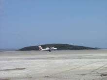
Barra's airport, near Northbay, uses the beach called An Tràigh Mhòr ("The Great Beach") as a runway. Planes can land and take off only at low tide, so the timetable varies. Voted the world's most stunning landing spot,[34] Barra's airport is claimed to be the only airport in the world to have scheduled flights landing on a beach.[35] The aircraft currently in operation on Barra is the de Havilland Canada DHC-6 Twin Otter, flown by Loganair to/from Glasgow. There are usually flights every day of the week in the summer. The beach is also a source of cockles.
Ferries to Oban, Lochboisdale, Tiree and Eriskay are run by Caledonian MacBrayne.[36] Castlebay is the main port from which ferries sail to Oban on the Scottish mainland, Tiree and Lochboisdale (Loch Baghasdail) in South Uist. The mainland crossing takes about 5 hours. A vehicular ferry travels between Ardmore (An Àird Mhòr) and Ceann a' Gharaidh in Eriskay (Èirisgeigh). The crossing takes around 40 minutes.
Industry and tourism
The fish factory, Barratlantic, in Northbay is a major contributor to the island's economy and the Hebridean Toffee Factory in Castlebay is one of the few manufacturers on Barra.[37]
Tourism provides the main income for the majority of islanders; the high season lasts from May to September. Thousands of people visit the island every year, the busiest times being during Fèis Bharraigh & BarraFest in July. The Dualchas Heritage and Cultural Centre is located in Castlebay, next to Castlebay Community School. It has various exhibitions each year, and is open throughout the year.[38]
In 2010 camping on the machair at the airport was banned due to erosion; this prompted crofters to provide areas on their crofts for visiting tourists.[39] Boat trips to the neighbouring island of Mingulay are available during the summer season, and island-hopping plane trips are also available.
A distillery is planned to be built in Borve,[40] on the west side of the island. The Isle of Barra Distillery[41] (trading as Uisge Beatha nan Eilean Ltd) has now installed four Proven 6 kW wind turbines[42] next to the reservoir Loch Uisge, which originally supplied the drinking water to Castlebay. It is proposed that as much as possible of the necessary resources to produce the whisky should come from Barra or the surrounding islands, with only the bare minimum necessary being imported from outside the island's economy.
Coimhearsachd Bharraigh agus Bhatarsaigh
Coimhearsachd Bharraidh agus Bhatarsaidh (Barra and Vatersay Community) Ltd is a community-owned company whose aim is to support community development on Barra and Vatersay. The company is managed by a volunteer board of directors drawn from the membership. Membership is open to residents of the two islands whose names appear on the voting register.[43]
The company's latest project is a 900 kW Enercon E-44 wind turbine being installed at Gòb Sgùrabhal, at the most north-westerly point of the island, and early indications are that the wind resource will make this one of the most productive 900 kW turbines in Western Europe.[44]
Gallery
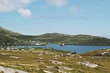 Castlebay, Barra
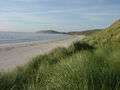 Traigh Eais
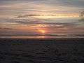 Sunset from Traigh Eais
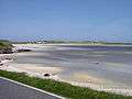 Airport Sands
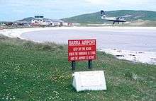
 Twin Otter taking off from Barra Airport
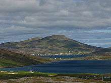 Castlebay and Heaval, from Vatersay
See also
- List of places in the Western Isles
- Angus MacNeil (b. 1970), Member of Parliament for Na h-Eileanan an Iar, 2005–
- Flora MacNeil (b. 1928) Scottish Gaelic singer and Barra native
- Mick MacNeil (b. 1958, Barra) Simple Minds keyboardist 1978–1990
- Fèis Bharraigh
Notes
- ↑ In May of that year, Channel 4's Time Team came to investigate the remains. The programme was broadcast on 20 January 2008.[10]
- ↑ Discovered in 1865, the gravestone is now located in Edinburgh, though a facsimile was later placed in the chapel near the stone's original location on Barra
- ↑ 4000 marks
- ↑ in surviving records, at least
- ↑ His full name was Roderick MacNeil
- ↑ for the sum of £38,050
References
- 1 2 Area and population ranks: there are c. 300 islands over 20 ha in extent and 93 permanently inhabited islands were listed in the 2011 census.
- 1 2 3 National Records of Scotland (15 August 2013) (pdf) Statistical Bulletin: 2011 Census: First Results on Population and Household Estimates for Scotland - Release 1C (Part Two). "Appendix 2: Population and households on Scotland’s inhabited islands". Retrieved 17 August 2013.
- 1 2 3 Haswell-Smith, Hamish (2004). The Scottish Islands. Edinburgh: Canongate. pp. 218–222. ISBN 978-1-84195-454-7.
- ↑ "Sheet 34, Barra". Ordnance Survey One-inch to the mile maps of Great Britain, Seventh Series, 1952–1961. National Library of Scotland. Retrieved 23 January 2016.
- ↑ General Register Office for Scotland (28 November 2003) Scotland's Census 2001 – Occasional Paper No 10: Statistics for Inhabited Islands. Retrieved 26 February 2012.
- ↑ Census 2011 stats BBC News. Retrieved 20 April 2014.
- ↑ "Barra, Dun Mhic Leoid". canmore.org.uk. Retrieved 2017-01-20.
- ↑ Undiscovered Scotland
- ↑ "Barra (Traigh Mhòr) Airport climate". Met Office. Retrieved 17 October 2015.
- ↑ "Barra, Western Isles". Channel 4. Archived from the original on 23 January 2008. Retrieved 21 January 2008.
- ↑ Abrams, L (2007). "Conversion and the Church in the Hebrides in the Viking Age". In Smith, BB; Taylor, S; Williams, G. West Over Sea: Studies in Scandinavian Sea-Borne Expansion and Settlement Before 1300. The Northern World: North Europe and the Baltic c. 400–1700 AD. Peoples, Economics and Cultures (series vol. 31). Leiden: Brill. pp. 169–193. ISBN 978-90-04-15893-1. ISSN 1569-1462.
- ↑ Kingship and Unity, Scotland 1000-1306, G. W. S. Barrow, Edinburgh University Press, 1981
- ↑ Galloglas: Hebridean and West Highland Mercenary Warrior Kindreds in Medieval Ireland, John Marsden, 2003
- ↑ Lismore: The Great Garden, Robert Hay, 2009, Birlinn Ltd
- ↑ Proceedings of the Society of Antiquaries of Scotland, 90 (1956-1957), A.A.M. Duncan, A.L Brown, pages 204-205
- ↑ The Kingdom of the Isles: Scotland's Western Seaboard, R. A. McDonald, 1997, Tuckwell Press
- ↑ Regesta Regum Scottorum VI ed. Bruce Webster (Edinburgh 1982) no. 73.
- ↑ Raven, JA (2005). Medieval Landscapes and Lordship in South Uist (PhD thesis). Vol. 1. University of Glasgow – via Glasgow Theses Service.
- ↑ Gregory, Donald, History of the Western Highlands and Isles of Scotland, from A.D. 1493 to A.D. 1625, with a brief introductory sketch, from A.D. 80 to A.D. 1493, Edinburgh, W. Tait, retrieved 11 May 2012 , p. 65
- ↑ Ross, John (6 September 2003). "A gift to Scotland – the isle of Barra". The Scotsman. Archived from the original on 17 July 2012. Retrieved 4 November 2007.
- ↑ "Isle of Barra's flag officially recognised". BBC News. 23 November 2017. Retrieved 26 May 2018.
- ↑ "Barra Flag". Flag Institute. Retrieved 26 May 2018.
- ↑ "Whisky Galore!". screenonline.org.uk. Retrieved 29 March 2008.
- ↑ "Grave of Compton MacKenzie, Eolaigearraidh, Barra" Photograph NF 7007. Geograph. Retrieved 4 April 2010.
- ↑ Rockets Galore! on IMDb Retrieved 4 April 2010.
- ↑ "Main Characters". Dad's Army Appreciation Society. Retrieved 7 August 2013.
- ↑ An Island Parish (Series 5) « Tiger Aspect Archived 9 June 2011 at the Wayback Machine.
- ↑ BBC – BBC Two Programmes – An Island Parish, Series 5, Getting to Know You
- ↑ "Set of stamps honours the courage of Britain's lifeboatmen and coastguards". The Times. 13 March 2008. Retrieved 26 December 2008.
- ↑ "Royal Mail Stamps 'Mayday – Rescue at Sea'". news.hmmm-uk.com. Archived from the original on 30 July 2009. Retrieved 26 December 2008.
- ↑ "Barrathon". Barrathon. Retrieved 21 October 2014.
- ↑ Madden, Richard (24 March 2009). "Kayaking in the Outer Hebrides". The Daily Telegraph.
- ↑ Joly, Dom (18 January 2010). "The shocking truth about golf on Barra". The Independent.
- ↑ "Barra airport is world's most scenic". BBC News Online.
- ↑ "Barra Airport". Highlands and Islands Airports Limited. Archived from the original on 22 March 2009. Retrieved 6 April 2009.
- ↑ "Barra". Caledonian MacBrayne. Archived from the original on 26 November 2009. Retrieved 15 October 2009.
- ↑ Cramb, Auslan (5 December 2008). "What makes Barra the best village in Britain?". The Daily Telegraph.
- ↑ "Dualchas". Comunn Eachdraidh Bharraidh agus Bhatarsaidh. Archived from the original on 5 July 2008. Retrieved 29 March 2008.
- ↑ "Camping and Motor Homes". Explore Scotland.
- ↑ "Isle of Barra Distillery Location". Google Maps. Retrieved 24 March 2013.
- ↑ "Isle of Barra Distillery". Retrieved 24 March 2013.
- ↑ "Isle of Barra Distillery Wind Turbines Installed on Site". Archived from the original on 29 July 2013. Retrieved 24 March 2013.
- ↑ "Coimhearsachd Bharraigh agus Bhatarsaigh". Isle of Barra. Retrieved 17 November 2013.
- ↑ "Community Wind Turbine for Barra". Stornoway Gazette. 21 October 2013.
External links
| Wikisource has the text of the 1911 Encyclopædia Britannica article Barra. |
| Wikimedia Commons has media related to Barra. |

- Explore the Isle of Barra
- Isle of Barra community website
- Barra Distillery
- Ferry Operator Caledonian MacBrayne
- Encyclopædia Britannica, Barra
- Barra weather
- National Library of Scotland: Scottish Screen Archive (1950s archive film about the island of Barra)
- Island Priest tears strip off agency for nude surfers stunt The Guardian 4 March 2008
Inhabited islands of the Hebrides | ||
|---|---|---|
| Inner Hebrides | 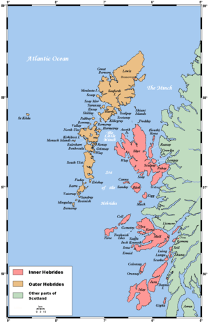 | |
| Outer Hebrides | ||
|  | ||||||||||||||||
|
| |||||||||||||||||
| |||||||||||||||||
| |||||||||||||||||
| |||||||||||||||||
| |||||||||||||||||
| |||||||||||||||||
| |||||||||||||||||