Barbican Estate
| Barbican Estate | |
|---|---|
 Barbican Towers | |
| General information | |
| Type | Mixed-use development |
| Architectural style | Brutalist |
| Town or city | London, EC2 |
| Country | England |
| Design and construction | |
| Architecture firm | Chamberlin, Powell and Bon |
| Structural engineer | Ove Arup & Partners |
| Civil engineer | Ove Arup & Partners |
| Designations | Grade II listed |
| Website | |
| Official website | |
The Barbican Estate is a residential estate that was built during the 1960s and the 1980s within the City of London in Central London, in an area once devastated by World War II bombings and today densely populated by financial institutions. It contains, or is adjacent to, the Barbican Arts Centre, the Museum of London, the Guildhall School of Music and Drama, the Barbican public library, the City of London School for Girls and a YMCA (now closed),[1] forming the Barbican Complex.
The Barbican Complex is a prominent example of British brutalist architecture and is Grade II listed as a whole[2] with the exception of the late Milton Court. Milton Court once contained a fire station, medical facilities, and some flats but was demolished to allow the construction of a new apartment complex, which also contains additional facilities for the Guildhall School of Music and Drama.
History
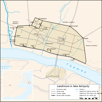
The main fort of Roman London was built between 90 and 120 AD southeast of where the Museum of London now stands at the corner of London Wall and Aldersgate Street.[3] Around 200 AD walls were built around the city that incorporated the old fort, which became a grand entrance known as Cripplegate. The word barbican comes from the Low Latin word Barbecana which referred to a fortified outpost or gateway, such as an outer defence of a city or castle or any tower situated over a gate or bridge which was used for defence purposes.[4] In this case there seems to have been a Roman specula or watchtower[5] in front of the fort at numbers 33–35[5] on the north side of the street then called Barbican[6] (now the west end of Beech St), which was later incorporated into the fortifications north of the wall. The Normans called it the Basse-cour or Base Court,[7] synonymous with the modern word "bailey" and still applied to the outer courtyard of Hampton Court Palace.
The Base Court continued to serve a military function during the reign of Edward I, but Edward III gave it to Robert d'Ufford, 1st Earl of Suffolk[6] who made it his London home. By the 16th century, it had passed to Charles Brandon, 1st Duke of Suffolk. Brandon married his ward Catherine Willoughby, daughter of Maria de Salinas who had been a confidante and lady-in-waiting of Catherine of Aragon and after his death was retained by the Willoughby family. The original Base Court seems to have been destroyed and the large building that replaced it was called Willoughby House, a name revived for part of the modern development.
Post-war development
During World War II, the City suffered serious damage and loss of life. The Cripplegate ward was virtually demolished[8] and by 1951 the resident population of the City stood at 5,324 of whom 48 lived in Cripplegate.[9] Discussions began in 1952 about the future of the site, and the decision to build new residential properties was taken by the Court of Common Council on 19 September 1957.[10]
The estate was built between 1965 and 1976, on a 35-acre (14 ha) site that had been bombed in World War II. The complex was designed by architects Chamberlin, Powell and Bon, whose first work was the ground-breaking Golden Lane Estate immediately north of the Barbican. The estate of 40 acres (16 ha) was officially opened in 1969 and is now home to around 4,000 people living in 2,014 flats.[10] The flats reflect the widespread use in Britain in the 1960s and 1970s of concrete as the visible face of the building.

The Minister for the Arts, Tessa Blackstone, announced in September 2001 that the Barbican complex was to be Grade II listed. It has been designated a site of special architectural interest for its scale, its cohesion and the ambition of the project.[11] The complex is architecturally important as it is one of London's principal examples of concrete brutalist architecture and considered a landmark.
Blocks and towers

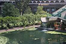
.jpg)
The residential estate consists of three tower blocks, 13 terrace blocks, two mews and The Postern, Wallside and Milton Court.[12]
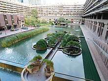
The terrace blocks
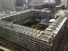
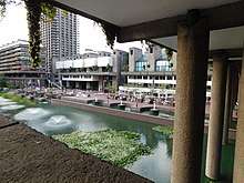
These are grouped around a lake and green squares. The main buildings rise up to seven floors above a podium level, which links all the facilities in the Barbican, providing a pedestrian route above street level. Some maisonettes are built into the podium structure. There is no vehicular access within the estate, but there are some car parks at its periphery. Public car parks are located within the Barbican Centre.
The terrace blocks are named:[12]
- Andrewes House – named after Lancelot Andrewes a 16th-century English bishop and scholar
- Breton House – named after Nicholas Breton a 16th-century English poet and novelist
- Bryer Court – named after W. Bryer & Sons gold refiners and assayers premises were Numbers 53 and 54 and demolished to make way for the building[13]
- Bunyan Court – named after John Bunyan, a 17th-century English writer and Baptist preacher
- Defoe House – named after Daniel Defoe
- Frobisher Crescent – named after Martin Frobisher, an English seaman and privateer
- Gilbert House – named after Humphrey Gilbert
- Ben Jonson House – named after Ben Jonson, an English playwright, poet and actor
- Thomas More House – named after Thomas More
- Mountjoy House – named after Christopher Mountjoy a French wig-maker who let a room to William Shakespeare[14]
- Seddon House – named after George Seddon, an English cabinetmaker
- Speed House – named after John Speed, an English cartographer and explorer
- John Trundle Court – named after John Trundle
- Willoughby House – named after Catherine Willoughby
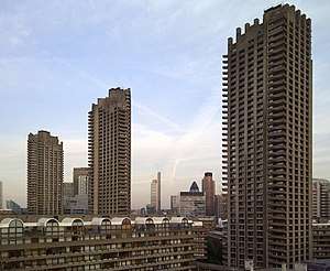
Tower blocks
The estate also contains three of London's tallest residential towers, at 42 storeys and 123 metres (404 ft) high. The top two or three floors of each block comprise three penthouse flats. The towers are (east to west):
- Cromwell Tower, completed in 1973 – named after Oliver Cromwell[15]
- Shakespeare Tower, completed in 1976 – named after William Shakespeare[16] and
- Lauderdale Tower, completed in 1974 – named after the Earls of Lauderdale[17]
Once the tallest residential towers in London, they were surpassed by the Pan Peninsula development on the Isle of Dogs.
Barbican complex
The Barbican Estate also contains the Barbican Centre (an arts, drama and business venue), the Barbican public library, the City of London School for Girls, the Museum of London, and the Guildhall School of Music and Drama. A YMCA building was constructed between 1965 and 1971[11] to link the Barbican and Golden Lane Estate; it is also listed. In 2015-16 the YMCA building was converted by Redrow Homes into a new residential block called Blake Tower with 74 flats run as part of the Barbican Estate.
In popular culture
The Barbican features in Michael Paraskos's novel In Search of Sixpence as the home of the lead character, Geroud, and also a bar called "The Gin Bar" loosely based on the Gin Joint bar at the Barbican Centre.[18]
The final scene of the 1983 vampire film, “The Hunger” directed by Tony Scott and starring David Bowie, Catherine Deneuve and Susan Sarandon, was filmed in the Cromwell Tower at the Barbican.
The Barbican towers can be seen in a sequence from the 1975 Disney film One of Our Dinosaurs is Missing, an unintentional anachronism for a film set in the 1920s.[19]
The Barbican was also used to represent MI6 headquarters in the James Bond film Quantum of Solace.[20]
Nearby rail and Tube
| Service | Station/Stop | Line/Route |
|---|---|---|
| National Rail | Liverpool Street | |
| Farringdon | ||
| London Underground | Liverpool Street | |
| Barbican | ||
| Moorgate | ||
| St. Paul's | ||
| Farringdon |
See also
References and notes
- ↑ "Finsbury Hostel Closure". Islington Gazette. Retrieved 2 February 2012.
- ↑ Historic England. "Details from listed building database (1352667)". National Heritage List for England. Retrieved 12 June 2011.
- ↑ "Quarterly Review (June to August 2002) Greater London Archaeology Advisory Service" (PDF). Quarterly Review. Greater London Archaeology Advisory Service. June–August 2002. p. 30. Archived from the original (PDF) on 4 January 2009.
- ↑ "Barbican Estate history - City of London". www.cityoflondon.gov.uk.
- 1 2 Britton, John. The Beauties of England and Wales, or, Delineations, topographical, historical, and descriptive, of each county, Volume 10, Part 3. Vernor and Hood. p. 216.
- 1 2 Strype, John (1720). "6". Survey of London. 3. Retrieved 19 March 2014.
- ↑ Goff, Cecilie (1930). A woman of the Tudor age. John Murray. p. 277.
- ↑ https://www.theguardian.com/cities/2015/sep/02/blitz-london-bomb-sites-redevelopment
- ↑ https://londonist.com/london/secret/5-secrets-of-barbican
- 1 2 "History of the Barbican Estate". City of London. Archived from the original on 7 December 2006. Retrieved 11 January 2007.
- 1 2 "Listing of the Barbican complex". City of London. Archived from the original on 8 October 2006. Retrieved 11 January 2007.
- 1 2 Jennifer Clarke (1990), The Barbican Sitting on History, Corporation of London Records Office, ISBN 9780852030301, OCLC 24713108, 0852030304
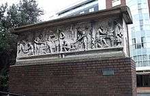
- ↑ "Barbican frieze". London Remembers.
- ↑ "The Mountjoys". barbicanliving.co.uk. 23 October 2015.
- ↑ "Cromwell Tower". Emporis Buildings. Retrieved 11 January 2007.
- ↑ "Shakespeare Tower". Emporis Buildings. Retrieved 11 January 2007.
- ↑ "Lauderdale Tower". Emporis Buildings. Retrieved 11 January 2007.
- ↑ Michael Paraskos, In Search of Sixpence (London: Friction Fiction, 2015) ISBN 9780992924782
- ↑ https://londonist.com/london/secret/5-secrets-of-barbican
- ↑ https://www.theguardian.com/film/2012/feb/29/exhibition-marks-50-years-james-bond-films
External links
| Wikimedia Commons has media related to Barbican Estate. |
- The history of the Barbican Estate
- Corporation of London:Barbican Estate
- Barbican Life magazine
- "Secret bits of the Barbican", Londonist
| Wards |  | |
|---|---|---|
| Enclaves | ||
| Localities | ||
| Attractions |
| |
| Notable structures | ||
| Civil parishes | ||
| Bridges | ||
| Rail and tube stations | ||
| Topics | ||
| ||