Avon, Illinois
| Avon, Illinois | |
|---|---|
| Village | |
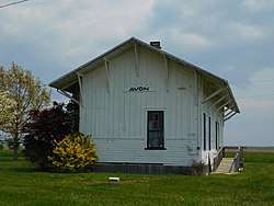 The former Chicago, Burlington and Quincy Railroad station in Avon, now located in Avon Town Park. | |
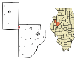 Location of Avon in Warren County, Illinois. | |
.svg.png) Location of Illinois in the United States | |
| Coordinates: 40°39′44″N 90°26′8″W / 40.66222°N 90.43556°WCoordinates: 40°39′44″N 90°26′8″W / 40.66222°N 90.43556°W | |
| Country | United States |
| State | Illinois |
| Counties | Fulton, Warren |
| Townships | Union, Greenbush |
| Government | |
| • Village President | Kim John Young |
| Area[1] | |
| • Total | 0.45 sq mi (1.18 km2) |
| • Land | 0.45 sq mi (1.18 km2) |
| • Water | 0.00 sq mi (0.00 km2) |
| Elevation | 640 ft (200 m) |
| Population (2010) | |
| • Total | 799 |
| • Estimate (2016)[2] | 751 |
| • Density | 1,654.19/sq mi (638.91/km2) |
| Time zone | UTC-6 (CST) |
| • Summer (DST) | UTC-5 (CDT) |
| ZIP Code(s) | 61415 |
| Area code(s) | 309-465 |
| FIPS code | 17-03207 |
| Wikimedia Commons | Avon, Illinois |
Avon is a village in Fulton County, Illinois, United States. The population was 799 at the 2010 census,[3] down from 915 at the 2000 census.[4]
Geography
Avon is located in northwestern Fulton County at 40°39′44″N 90°26′8″W / 40.66222°N 90.43556°W (40.662254, -90.435485).[5] A small portion of the village extends west into Warren County. Illinois Route 41 passes through the village, leading north 21 miles (34 km) to Galesburg and southwest 10 miles (16 km) to Bushnell.
According to the 2010 census, Avon has a total area of 0.45 square miles (1.17 km2), all land.[6]
History
Ira Woods and his family settled in Avon in 1835. Avon was named "Woodsville" from 1837 to 1843. In 1843, the town became big enough to ask for a post office. The name was then changed to "Woodstock". On April 4, 1852, the United States Postmaster General gave the town the name of "Avon" to avoid confusion with another community in McHenry County, IL.[7] Avon was once a thriving town, due in part to the railroad industry, by serving as a method of transporting cattle to the slaughterhouses in Chicago and also as a stop between Chicago and Quincy.
Demographics
| Historical population | |||
|---|---|---|---|
| Census | Pop. | %± | |
| 1860 | 594 | — | |
| 1870 | 672 | 13.1% | |
| 1880 | 689 | 2.5% | |
| 1890 | 692 | 0.4% | |
| 1900 | 809 | 16.9% | |
| 1910 | 865 | 6.9% | |
| 1920 | 877 | 1.4% | |
| 1930 | 799 | −8.9% | |
| 1940 | 803 | 0.5% | |
| 1950 | 870 | 8.3% | |
| 1960 | 996 | 14.5% | |
| 1970 | 1,013 | 1.7% | |
| 1980 | 1,019 | 0.6% | |
| 1990 | 957 | −6.1% | |
| 2000 | 915 | −4.4% | |
| 2010 | 799 | −12.7% | |
| Est. 2016 | 751 | [2] | −6.0% |
| U.S. Decennial Census[8] | |||
As of the census[9] of 2000, there were 915 people, 375 households, and 260 families residing in the village. The population density was 2,065.3 people per square mile (802.9/km²). There were 403 housing units at an average density of 909.6 per square mile (353.6/km²). The racial makeup of the village was 98.80% White, 0.11% Native American, 0.11% Asian, 0.66% from other races, and 0.33% from two or more races. Hispanic or Latino of any race were 0.77% of the population.
There were 375 households out of which 29.1% had children under the age of 18 living with them, 52.3% were married couples living together, 12.5% had a female householder with no husband present, and 30.4% were non-families. 26.7% of all households were made up of individuals and 15.2% had someone living alone who was 65 years of age or older. The average household size was 2.44 and the average family size was 2.93.
In the village, the population was spread out with 24.0% under the age of 18, 8.3% from 18 to 24, 25.0% from 25 to 44, 21.9% from 45 to 64, and 20.8% who were 65 years of age or older. The median age was 40 years. For every 100 females, there were 93.9 males. For every 100 females age 18 and over, there were 86.3 males.
The median income for a household in the village was $33,417, and the median income for a family was $38,819. Males had a median income of $30,167 versus $21,429 for females. The per capita income for the village was $16,257. About 9.9% of families and 11.7% of the population were below the poverty line, including 16.7% of those under age 18 and 10.8% of those age 65 or over.
Notable people
- Ken Carpenter, radio and TV announcer
References
- ↑ "2016 U.S. Gazetteer Files". United States Census Bureau. Retrieved Jun 30, 2017.
- 1 2 "Population and Housing Unit Estimates". Retrieved June 9, 2017.
- ↑ "Geographic Identifiers: 2010 Census Summary File 1 (G001), Avon village, Illinois". American FactFinder. U.S. Census Bureau. Retrieved May 13, 2016.
- ↑ City data. 2000 census information Retrieved on May 17, 2007
- ↑ "US Gazetteer files: 2010, 2000, and 1990". United States Census Bureau. 2011-02-12. Retrieved 2011-04-23.
- ↑ "G001 - Geographic Identifiers - 2010 Census Summary File 1". United States Census Bureau. Retrieved 2015-08-01.
- ↑ Baughman, Josie (1976). History of Avon. Carlberg Publishing Co. p. 7. OCLC 953873978.
- ↑ "Census of Population and Housing". Census.gov. Archived from the original on May 12, 2015. Retrieved June 4, 2015.
- ↑ "American FactFinder". United States Census Bureau. Archived from the original on 2013-09-11. Retrieved 2008-01-31.
Municipalities and communities of Fulton County, Illinois, United States | ||
|---|---|---|
| Cities | ||
| Town | ||
| Villages | ||
| Townships | ||
| Unincorporated communities | ||
| Ghost towns | ||
| Footnotes | ‡This populated place also has portions in an adjacent county or counties | |
Municipalities and communities of Warren County, Illinois, United States | ||
|---|---|---|
| Cities | ||
| Villages | ||
| Townships | ||
| Unincorporated communities | ||
| Footnotes | ‡This populated place also has portions in an adjacent county or counties | |