Ipava, Illinois
| Ipava, Illinois | |
|---|---|
| Village | |
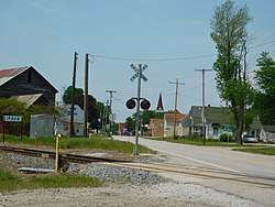 Ipava along U.S. Route 136 | |
 Location of Ipava in Fulton County, Illinois. | |
.svg.png) Location of Illinois in the United States | |
| Coordinates: 40°21′8″N 90°19′24″W / 40.35222°N 90.32333°WCoordinates: 40°21′8″N 90°19′24″W / 40.35222°N 90.32333°W | |
| Country | United States |
| State | Illinois |
| County | Fulton |
| Township | Pleasant |
| Area[1] | |
| • Total | 0.27 sq mi (0.69 km2) |
| • Land | 0.27 sq mi (0.69 km2) |
| • Water | 0.00 sq mi (0.00 km2) |
| Elevation | 660 ft (200 m) |
| Population (2010) | |
| • Total | 470 |
| • Estimate (2016)[2] | 440 |
| • Density | 1,641.79/sq mi (633.82/km2) |
| Time zone | UTC-6 (CST) |
| • Summer (DST) | UTC-5 (CDT) |
| ZIP Code(s) | 61441 |
| Area code(s) | 309 |
| FIPS code | 17-37647 |
Ipava is a village in Fulton County, Illinois, United States. The population was 470 at the 2010 census.[3]
Geography
Ipava is located in southern Fulton County at 40°21′8″N 90°19′24″W / 40.35222°N 90.32333°W (40.352123, -90.323343).[4] U.S. Route 136 passes through the village, leading east 17 miles (27 km) to Havana on the Illinois River and west 6 miles (10 km) to Table Grove. Lewistown, the Fulton County seat, is 12 miles (19 km) to the northeast via US 136 and US 24.
According to the 2010 census, Ipava has a total area of 0.27 square miles (0.70 km2), all land.[5]
Demographics
| Historical population | |||
|---|---|---|---|
| Census | Pop. | %± | |
| 1860 | 299 | — | |
| 1870 | 488 | 63.2% | |
| 1880 | 675 | 38.3% | |
| 1890 | 667 | −1.2% | |
| 1900 | 749 | 12.3% | |
| 1910 | 652 | −13.0% | |
| 1920 | 720 | 10.4% | |
| 1930 | 635 | −11.8% | |
| 1940 | 629 | −0.9% | |
| 1950 | 667 | 6.0% | |
| 1960 | 623 | −6.6% | |
| 1970 | 608 | −2.4% | |
| 1980 | 661 | 8.7% | |
| 1990 | 483 | −26.9% | |
| 2000 | 506 | 4.8% | |
| 2010 | 470 | −7.1% | |
| Est. 2016 | 440 | [2] | −6.4% |
| U.S. Decennial Census[6] | |||
As of the census[7] of 2000, there were 506 people, 222 households, and 144 families residing in the village. The population density was 1,877.0 people per square mile (723.6/km²). There were 242 housing units at an average density of 897.7 per square mile (346.1/km²). The racial makeup of the village was 99.60% White, 0.20% Asian, and 0.20% from two or more races. Hispanic or Latino of any race were 0.40% of the population.
There were 222 households out of which 24.8% had children under the age of 18 living with them, 55.4% were married couples living together, 6.3% had a female householder with no husband present, and 34.7% were non-families. 33.3% of all households were made up of individuals and 18.5% had someone living alone who was 65 years of age or older. The average household size was 2.28 and the average family size was 2.90.
In the village, the population was spread out with 23.5% under the age of 18, 6.5% from 18 to 24, 26.1% from 25 to 44, 25.1% from 45 to 64, and 18.8% who were 65 years of age or older. The median age was 40 years. For every 100 females, there were 101.6 males. For every 100 females age 18 and over, there were 98.5 males.
The median income for a household in the village was $31,250, and the median income for a family was $41,389. Males had a median income of $34,063 versus $22,679 for females. The per capita income for the village was $16,007. About 9.0% of families and 10.1% of the population were below the poverty line, including 16.8% of those under age 18 and 9.3% of those age 65 or over.
Notable people
- Jack Fisk, actor and director, married to actress Sissy Spacek; born to Jack Fisk Sr. and Geraldine Fisk of Ipava on December 19, 1945
- Frank Lovell, politician with the Socialist Workers Party; born in Ipava
References
- ↑ "2016 U.S. Gazetteer Files". United States Census Bureau. Retrieved Jun 29, 2017.
- 1 2 "Population and Housing Unit Estimates". Retrieved June 9, 2017.
- ↑ "Geographic Identifiers: 2010 Census Summary File 1 (G001), Ipava village, Illinois". American FactFinder. U.S. Census Bureau. Retrieved May 17, 2016.
- ↑ "US Gazetteer files: 2010, 2000, and 1990". United States Census Bureau. 2011-02-12. Retrieved 2011-04-23.
- ↑ "G001 - Geographic Identifiers - 2010 Census Summary File 1". United States Census Bureau. Retrieved 2015-08-04.
- ↑ "Census of Population and Housing". Census.gov. Archived from the original on May 12, 2015. Retrieved June 4, 2015.
- ↑ "American FactFinder". United States Census Bureau. Retrieved 2008-01-31.
Municipalities and communities of Fulton County, Illinois, United States | ||
|---|---|---|
| Cities | ||
| Town | ||
| Villages | ||
| Townships | ||
| Unincorporated communities | ||
| Ghost towns | ||
| Footnotes | ‡This populated place also has portions in an adjacent county or counties | |