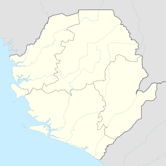
Freetown
| Freetown | |
|---|---|
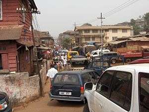
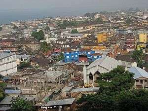 View of Freetown | |
 Freetown  Freetown | |
| Coordinates: 8°29′4″N 13°14′4″W / 8.48444°N 13.23444°WCoordinates: 8°29′4″N 13°14′4″W / 8.48444°N 13.23444°W | |
| Country |
|
| Region | Western Area |
| District | Western Area Urban District |
| Founded | March 11, 1792 |
| Government | |
| • Type | City council |
| • Mayor | Yvonne Aki-Sawyerr[1] (APC) |
| • Governing Body | Freetown City Council |
| Area[2] | |
| • City | 81.48 km2 (31.46 sq mi) |
| Elevation | 26 m (85 ft) |
| Population (2015 Census[3]) | |
| • City | 1,055,964 |
| • Density | 13,000/km2 (34,000/sq mi) |
| • Metro | 1,500,234 |
| Time zone | Greenwich Mean Time |
Freetown is the capital and largest city of Sierra Leone. It is a major port city on the Atlantic Ocean and is located in the Western Area of the country. Freetown is Sierra Leone's major urban, economic, financial, cultural, educational and political centre, as it is the seat of the Government of Sierra Leone. The population of Freetown is 1,055,964 at the 2015 census.[3]
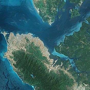
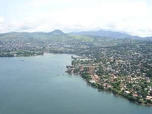
The city's economy revolves largely around its harbour, which occupies a part of the estuary of the Sierra Leone River in one of the world's largest natural deep water harbours.
The population of Freetown is ethnically, culturally, and religiously diverse. The city is home to a significant population of all of Sierra Leone's ethnic groups, with no single ethnic group forming more than 29% of the city's population. As in virtually all parts of Sierra Leone, the Krio language is Freetown's primary language of communication and is by far the most widely spoken language in the city.
The city of Freetown was founded on March 11, 1792 by Lieutenant John Clarkson and African American ex-slaves and free people called the Nova Scotian Settlers, who were transported to Sierra Leone by the Sierra Leone Company in 1792. The city of Freetown was a haven for free-born and freed African American, Liberated African and Caribbean settlers; and their descendants are known as the Creole people. Freetown is the oldest capital to be founded by African Americans, having been founded thirty years before Monrovia, Liberia and is noted for its unique Creole architecture reflecting American and Caribbean influences.
Freetown is locally governed by the Freetown City Council, headed by a mayor. The mayor and members of the Freetown City Council are directly elected by the residents of Freetown in an election held every four years. The current mayor of Freetown is Yvonne Aki Sawyerr, who was sworn in on May 11, 2018, after her victory in the 2018 Freetown Mayoral election.[4] The Freetown city council has its own municipal police force.
The city of Freetown is divided into three municipal regions; the East End, Central, and the West End, which in turns are divided into 8 electoral wards: East I, East II, East III, Central I, Central II, West I, West II, and West III. The East End is both the most populous, and the most densely populous of the three regions within Freetown.
History
Province of Freedom (1787–1789)
The area was first settled in 1787 by 400 formerly enslaved black people sent from London, England, under the auspices of the Committee for the Relief of the Black Poor, an organisation set up by Jonah Hanway and the British abolitionist, Granville Sharp. These black people were African Americans, Afro-Caribbeans, Africans, Southeast Asians, and black people born in Great Britain. They established the 'Province of Freedom' and the settlement of Granville Town on land purchased from local Koya Temne subchief King Tom and regent Naimbana. The British understood the purchase meant that their new settlers had the land "for ever." Although the established arrangement between Europeans and the Koya Temne included provisions for permanent settlement, some historians question how well the Koya leaders understood the agreement, as they had a different conception of the uses of property.
Disputes soon broke out. King Tom's successor, King Jimmy, burnt the settlement to the ground in 1789. Alexander Falconbridge was sent to Sierra Leone in 1791 to collect the remaining Black Poor settlers, and they re-established Granville Town around the area now known as Cline Town, Sierra Leone near Fourah Bay. These 1787 settlers did not formally establish Freetown, even though the bicentennial of Freetown was celebrated in 1987. But formally, Freetown was founded in 1792.[5]
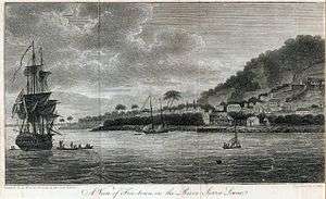
Freetown Colony (1792–1808)
.jpg)

In 1791, Thomas Peters, an African American who had served in the Black Pioneers, went to England to report the grievances of the black population in Nova Scotia. Some of these African Americans were ex-slaves who had escaped to the British forces who had been given their freedom and resettled there by the Crown after the American Revolution. Land grants and assistance in starting the settlements had been intermittent and slow.
During his visit, Peters met with the directors of the Sierra Leone Company and learned of proposals for a new settlement at Sierra Leone. Despite the collapse of the 1787 colony, the directors were eager to recruit settlers to Sierra Leone. Lieutenant John Clarkson, RN, who was an abolitionist, was sent to Nova Scotia in British North America to register immigrants to take to Sierra Leone for a new settlement.
Tired of the harsh weather and racial discrimination in Nova Scotia, more than 1,100 former American slaves chose to go to Sierra Leone. They sailed in 15 ships and arrived in St. George Bay between February 26 – March 9, 1792. Sixty-four settlers died en route to Sierra Leone, and Lieutenant Clarkson was among those taken ill during the voyage. Upon reaching Sierra Leone, Clarkson and some of the Nova Scotian 'captains' "dispatched on shore to clear or make roadway for their landing". The Nova Scotians were to build Freetown on the former site of the first Granville Town, where jungle had taken over since its destruction in 1789. Its surviving Old Settlers had relocated to Fourah Bay in 1791.
At Freetown, the women remained in the ships while the men worked to clear the land. Lt. Clarkson told the men to clear the land until they reached a large cotton tree. After the work had been done and the land cleared, all the Nova Scotians, men and women, disembarked and marched towards the thick forest and to the cotton tree, and their preachers (all African Americans) began singing "Awake and Sing of Moses and the Lamb."
In March 1792, Nathaniel Gilbert, a white preacher, prayed and preached a sermon under the large Cotton Tree, and Reverend David George, from South Carolina, preached the first recorded Baptist service in Africa. The land was dedicated and christened 'Free Town,' as ordered by the Sierra Leone Company Directors. This was the first thanksgiving service.
John Clarkson was sworn in as first governor of Sierra Leone. Small huts were erected before the rainy season. The Sierra Leone Company surveyors and the settlers built Freetown on the American grid pattern, with parallel streets and wide roads, with the largest being Water Street. On August 24, 1792, the Black Poor or Old Settlers of the second Granville Town were incorporated into the new Sierra Leone Colony, but remained at Granville Town.
In 1793, the settlers sent a petition to the Sierra Leone Company expressing concerns about the treatment that they were enduring.[6] The settlers in particular objected to being issued currency that was only redeemable at a company owned store. They also claimed that the governor, Mr. Dawes ruled in an almost tyrannical fashion, favoring certain people over others when ruling the settlement. The writers then argued that they had not received the amount of land that Lt. Clarkson had promised them on leaving Nova Scotia. The letter expressed anxiety that the company was not treating them as freemen, but as slaves and requested that Lt. Clarkson return as governor.
Freetown survived being pillaged by the French in 1794, and was rebuilt by the settlers. By 1798, Freetown had between 300–400 houses with architecture resembling that of the United States – stone foundations with wooden superstructures. Eventually this style of housing, built by the Nova Scotians, would be the model for the 'bod oses' of their Creole descendants.
In 1800, the Nova Scotians rebelled. The British authorities used the arrival of about 550 Jamaican Maroons to suppress the insurrection. Thirty-four Nova Scotians were banished and sent to either the Sherbro or a penal colony at Gore. Some of the Nova Scotians were eventually allowed back into Freetown. After the Maroons captured the Nova Scotian rebels, they were granted their land. Eventually the Maroons had their own district, which came to be known as Maroon Town.
Freetown as a Crown Colony (1808–1961)
Indigenous Africans attacked the colony in 1801 and were repulsed. The British eventually took control of Freetown, making it a Crown Colony in 1808. This act accompanied expansion that led to the creation of Sierra Leone.
From 1808 to 1874, the city served as the capital of British West Africa. It also served as the base for the Royal Navy's West Africa Squadron, which was charged with enforcing the ban on the slave trade. When the squadron liberated slaves on trading ships, they brought most to Sierra Leone, and Freetown in particular; thus, the population grew to include descendants of many different peoples from all over the west coast of Africa. The British also situated three of their Mixed Commission Courts in Freetown.[7]
The liberated Africans established the suburbs of Freetown Peninsula. They were the largest group of immigrants to make up the Creole people of Freetown. The city expanded rapidly. The freed slaves were joined by West Indian and African soldiers, who had fought for Britain in the Napoleonic Wars and settled here afterward. Descendants of the freed slaves who settled in Sierra Leone between 1787 and 1792, are called the Creoles. The Creoles play a leading role in the city, although they are a minority of the overall Sierra Leone population.
During World War I Freetown became a base for operations of British forces in the Atlantic. Warships came into the port to resupply and German merchant vessels captured in the region were also sent there.[8]
During World War II, Britain maintained a naval base at Freetown. The base was a staging post for Allied traffic in the South Atlantic and the assembly point for SL convoys to Britain. An RAF base was maintained at nearby Lungi airfield.
Civil war, 1990s
The city was the scene of fierce fighting in the late 1990s during the Sierra Leone Civil War. It was captured by ECOWAS troops seeking to restore President Ahmad Tejan Kabbah in 1998. Later it was unsuccessfully attacked by rebels of the Revolutionary United Front.
Mudslide disaster, 2017
In the early morning on 14 August 2017, after much heavy rain part of Mount Sugar Loaf on an edge of Freetown collapsed in a huge mudslide which drowned over 300 people in Regent town. Deforestation has been blamed for the landslide.[9][10][11][12]
Government and politics
The city of Freetown is one of Sierra Leone's six municipalities and is governed by a directly elected city council, headed by a mayor, in whom executive authority is vested. The mayor is responsible for the general management of the city. The mayor and members of the Freetown Municipality are elected directly by the residents of Freetown in every four years.
The government of the Freetown Municipality has been dominated by All People's Congress (APC) since 2004. Since 2004, the residents of Freetown has voted in municipal elections for members of the All People's Congress (APC) by an overwhelming majority. The APC won the city's mayorship and vast majority seats in the Freetown city council in the 2004, 2008, 2012 and 2018 local elections by more than 67% each.
In Presidential elections Freetown is considered a swing city, as it's has large support base of both the All People's Congress and the Sierra Leone People's Party. However, the APC has won majority percent of the votes in Freetown in the 2007, 2012 and 2018 Sierra Leone Presidential election, including The APC wining more than 65% of the votes in Freetown in both The 2012 nd 2018 Sierra Leone Presidential elections. The APC presidential candidate Ernest Bai Koroma received 69% of the votes in Freetown in the 2012 Sierra Leone Presidential election; compared to the SLPP presidential candidate Julius Maada Bio who received 30%. In the 2018 Sierra Leone Presidential election, The APC presidential candidate Samura Kamara received 65% compared to the SLPP presidential candidate Julius Maada Bio who received 34%, though Maada Bio won the presidential election nationally.
In November 2011, Freetown Mayor Herbert George-Williams was removed from office and replaced by council member Alhaji Gibril Kanu as acting mayor. Mayor Herbert George-Williams and eight others, including the Chief Administrator of the Freetown city council Bowenson Fredrick Philips; and the Freetown city council Treasurer Sylvester Momoh Konnehi, were arrested and indicted by the Sierra Leone Anti-corruption Commission on twenty-five counts on graft charges, ranging with conspiracy to commit corruption and misappropriation of public funds. Mayor Herbert George-Williams was acquitted of seventeen of the nineteen charges against him. He was convicted of two less serious charges by the Freetown High Court judge Jon Bosco Katutsi and sentenced to pay a fine.[13][14]
Acting Mayor Kanu lost the APC nomination for the mayor of Freetown in the 2012 Mayoral elections by 56 votes; council member Sam Franklyn Bode Gibson won 106 in a landslide victory[15][16]
In the national presidential and Parliamentary elections, Freetown is similar to swing states in American politics. As the city is so ethnically diverse, no single ethnic group forms a majority of the population of the city. Traditionally, the APC and the SLPP, two of the country's major political parties, have about equal support in the city. In the 2007 Sierra Leone Presidential election, the APC candidate and then main opposition leader, Ernest Bai Koroma, won just over 60% of the votes in the Western Area Urban District, including the city of Freetown, where almost the entire District population reside.
Geography
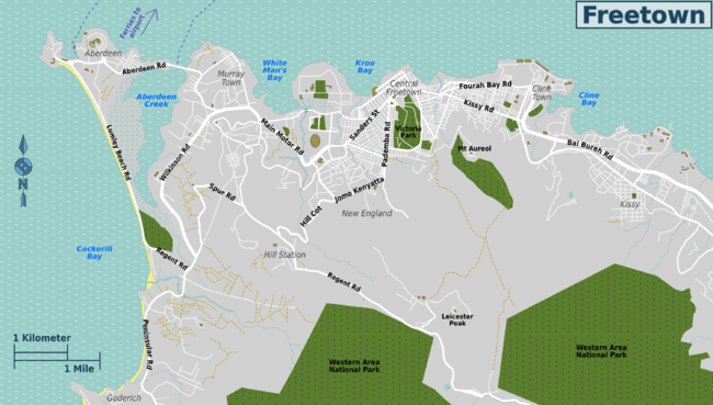
Freetown shares border with the Atlantic Ocean and the Western Area Rural District. Freetown municipality is politically divided into three regions: East End, Central and West End of Freetown. The wards in the East End of Freetown (East I, East II, and East III) contain the city's largest population centre and generally the poorest part of the city. The Queen Elizabeth II Quay is located within East End.
The two central wards (Central I and Central II) make up Central Freetown, which includes Downtown Freetown and the central business district (Central II). Most of the tallest and most important national government building and foreign embassies are based in Central Freetown.
Sierra Leone's House of Parliament and the State House, the principal workplace of the president of Sierra Leone, are on Tower Hill in central Freetown. The National Stadium, the home stadium of the Sierra Leone national football team (popularly known as the Leone Stars) is in the Brookfield neighborhood.
The three westernmost wards (West I, West II, and West III) of the city constitute the West End of Freetown. These wards are relatively affluent. Most of the city's luxury hotels, a number of casinos, and the Lumley Beach are in the west end of the city. The west end neighbourhood of Hill Station is home to the State Lodge, the official residence of the president of Sierra Leone.
Sights and attractions
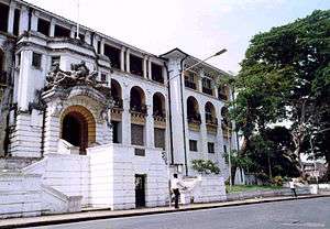
Freetown has an abundance of historical landmarks connected to its founding by Americans, liberated African slaves, and West Indians. The Cotton Tree represents the christening of Freetown in March 1792. In downtown Freetown is the Connaught Hospital, the first hospital constructed in West Africa that incorporated Western medical practices and the only hospital in the world with a dedicated 'Lassa Ward' - a ward solely dedicated to treating patients suffering from Lassa Fever[17].
Nearby is "King's Gate", built in stone with a statement inscribed which reads "any slave who passes through this gate is declared a free man", and it was this gate through which liberated Africans passed. Down by the Naval Wharf are slave steps carved out of stone. Before Freetown was established, this was where the Portuguese slave traders transported Africans as slaves to ships.
Freetown is home to Fourah Bay College, the oldest university in West Africa, founded in 1827. The university played a key role in Sierra Leone's colonial history. The college's first student, Samuel Ajayi Crowther, went on to be named as the first indigenous Bishop of West Africa. National Railway Museum has a coach car built for the state visit of Elizabeth II in 1961. The Big Market on Wallace Johnson Street is the showcase for local artisans' work.
The Freetown peninsula is ringed by long stretches of white sand. Lumley Beach, on the western side of the peninsula, is a popular location for local parties and festivals. Freetown is the seat of St John's Maroon Church (built around 1820), St. George Cathedral (completed in 1828), and Foulah Town Mosque (built in the 1830s). Also in Freetown are assorted beaches and markets, and the Sierra Leone Museum featuring the Ruiter Stone.
Economy
Freetown is the economic and financial centre of Sierra Leone. The country's state television and radio station, the Sierra Leone Broadcasting Corporation, is primarily based in Freetown. They have regional headquarters in the country's other primary cities of Bo, Kailahun, Kenema, Koidu Town, Magburaka and Makeni. The other national broadcasters, such as Capital Radio, are also based in Freetown. Many of the country's largest corporations locate their headquarters' home offices in Freetown as well as the majority of international companies.
The city's economy revolves largely around its final natural harbour, which is the largest natural harbour on the continent of Africa. Queen Elizabeth II Quay is capable of receiving oceangoing vessels and handles Sierra Leone's main exports.
Industries include food and beverage processing, fish packing, rice milling, petroleum refining, diamond cutting, and the manufacture of cigarettes, paint, shoes, and beer. the Fula and Sierra Leonean-Lebanese play a major role in local trade in the city.
The city is served by the Lungi International Airport, located in the city of Lungi, across the river estuary from Freetown.
Climate

Like the rest of Sierra Leone, Freetown has a tropical climate with a rainy season from May through to October; the balance of the year represents the dry season. The beginning and end of the rainy season is marked by strong thunderstorms. Under the Köppen climate classification, Freetown has a tropical monsoon climate primarily due to the heavy amount of precipitation it receives during the rainy season.
Freetown's high humidity is somewhat relieved November through to February by the famous Harmattan, a wind blowing from the Sahara Desert affording Freetown its coolest period of the year. Temperature extremes recorded in Freetown are from 15 °C (59 °F) to 38 °C (100 °F) all year. The average annual temperature is around 28 °C (82 °F).
| Climate data for Freetown, Sierra Leone (1961–1990, extremes 1947–1990) | |||||||||||||
|---|---|---|---|---|---|---|---|---|---|---|---|---|---|
| Month | Jan | Feb | Mar | Apr | May | Jun | Jul | Aug | Sep | Oct | Nov | Dec | Year |
| Record high °C (°F) | 36.0 (96.8) |
38.0 (100.4) |
38.0 (100.4) |
38.5 (101.3) |
35.0 (95) |
35.0 (95) |
33.0 (91.4) |
32.0 (89.6) |
31.0 (87.8) |
35.0 (95) |
36.5 (97.7) |
33.5 (92.3) |
38.5 (101.3) |
| Average high °C (°F) | 29.9 (85.8) |
30.3 (86.5) |
30.9 (87.6) |
31.2 (88.2) |
30.9 (87.6) |
30.1 (86.2) |
28.7 (83.7) |
28.4 (83.1) |
29.0 (84.2) |
29.9 (85.8) |
30.1 (86.2) |
29.7 (85.5) |
29.9 (85.8) |
| Daily mean °C (°F) | 27.3 (81.1) |
27.6 (81.7) |
28.1 (82.6) |
28.5 (83.3) |
28.3 (82.9) |
27.4 (81.3) |
26.3 (79.3) |
25.9 (78.6) |
26.4 (79.5) |
27.1 (80.8) |
27.7 (81.9) |
27.5 (81.5) |
27.3 (81.1) |
| Average low °C (°F) | 23.8 (74.8) |
24.0 (75.2) |
24.4 (75.9) |
24.8 (76.6) |
24.4 (75.9) |
23.6 (74.5) |
23.1 (73.6) |
23.0 (73.4) |
23.1 (73.6) |
23.4 (74.1) |
24.0 (75.2) |
24.1 (75.4) |
23.8 (74.8) |
| Record low °C (°F) | 15.0 (59) |
17.8 (64) |
19.4 (66.9) |
20.0 (68) |
20.6 (69.1) |
20.0 (68) |
19.4 (66.9) |
19.4 (66.9) |
20.0 (68) |
19.4 (66.9) |
20.0 (68) |
15.6 (60.1) |
15.0 (59) |
| Average rainfall mm (inches) | 3.4 (0.134) |
3.6 (0.142) |
12.5 (0.492) |
46.9 (1.846) |
177.2 (6.976) |
323.0 (12.717) |
734.3 (28.909) |
791.1 (31.146) |
484.1 (19.059) |
265.8 (10.465) |
87.5 (3.445) |
15.9 (0.626) |
2,945.3 (115.957) |
| Average rainy days | 0 | 0 | 1 | 4 | 15 | 22 | 27 | 27 | 24 | 21 | 9 | 2 | 152 |
| Average relative humidity (%) (at 15:00 LST) | 66 | 67 | 67 | 68 | 73 | 76 | 81 | 82 | 80 | 78 | 76 | 69 | 74 |
| Mean monthly sunshine hours | 226.3 | 215.6 | 232.5 | 207.0 | 189.1 | 153.0 | 102.3 | 86.8 | 126.0 | 186.0 | 198.0 | 161.2 | 2,083.8 |
| Source #1: NOAA[18][19] | |||||||||||||
| Source #2: Deutscher Wetterdienst (extremes)[20] | |||||||||||||
Society
Demography
Freetown is home to a large population of both Muslims and Christians, though Muslims make up the majority of the population. In both the Muslim and Christian youth population of Freetown can be found a significant liberal influence. Like the rest of Sierra Leone, Freetown is a very religiously tolerant city, with Muslims and Christians living side by side and getting along well.
As in virtually all parts of Sierra Leone, the Krio language (the native language of the Creole people who make up 5% of the country's population) is by far the most widely spoken language in the city. The language is spoken at home as a first language by over 95% of the city's population and is spoken as a lingua franca by the entire population in the city. English (the country's official language) is also widely spoken, particularly by the well educated.
Crime
Since the end of civil war in 2002, Freetown has had an increase in robberies and violent crime: murders, home invasion, and assault. This effect is most pronounced in the East End of Freetown. But crime levels (especially violent crime) are comparatively low by regional and international standards.
Education
Freetown (as the rest of Sierra Leone) has an education system with six years of primary school (Classes 1 to 6), and six years of secondary school (Forms 1 to 6). Secondary schools are further divided into Junior secondary school (Forms 1 to 3) and Senior secondary school (Forms 4 to 6). This system is known as the 6-3-3-4 education system, which means: 6 years of Primary, 3 years of Junior Secondary, 3 years of Senior Secondary, and 4 years of University.
Primary school pupils are usually aged 6 to 12, and secondary schools are usually aged 13 to 18. Primary Education is free and compulsory in government-sponsored public schools. Freetown is home to one of the country's two main universities, the Fourah Bay College, the oldest university in West Africa, founded in 1827.
Transport infrastructure
Air transportation
Lungi International Airport is the international airport which serves Freetown and the rest of the country. It is located in the town of Lungi, about 17 km northeast of Freetown across the sea. It serves as the primary airport for domestic and international travel to and from Sierra Leone. The airport is operated by Sierra Leone Airports Authority. There is a frequent commercial hovercraft, bus, and ferry service to Freetown and other parts of the country. Hastings Airport provides secondary service, but can only handle small aircraft because of its short runway. It is located about 14 km southeast of downtown Freetown (nearly 22 km by road).[21]
Transfers to Freetown
Passengers have the choice of hovercraft, ferry, road (5 hours), speedboat, water taxi, local banana boats and helicopter to cross the river to Freetown. Ferry is the cheapest option. Hovercraft and ferry operations have at times been suspended due to passenger overloads and safety issues.
Access by sea
Sierra Leone has the largest natural harbour in the African continent. Ships from all over the globe berth at Freetown's Queen Elizabeth II Quay. Passenger, cargo, and private craft also utilize Government Wharf nearer to central Freetown. Recent investment has seen the introduction of high-tech cargo scanning facilities.
Access by land
Road
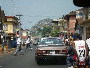
Sierra Leone's infrastructure is limited, and its highways and roads reflect this. The roads and highways of the country are administered by the Sierra Leone Roads Authority (SLRA) which has often been crippled by corruption. Highway 1 enters the city from the town of Waterloo several kilometers to the south. Despite the SLRA's limited capabilities, main feeder/trunk roads have been reconstructed to a high standard.
Railway
Following a recommendation from the IBRD, the Sierra Leone Government Railway which linked Freetown to the rest of the country was permanently closed in 1974. The iron rails were looted in the following years.
Sports
Like the rest of Sierra Leone, football is the most popular sport in Freetown. The Sierra Leone national football team, popularly known as the Leone Stars plays all their home games at Freetown's National Stadium, the largest stadium in Sierra Leone.
Eight of the fifteen clubs in the Sierra Leone National Premier League are from Freetown, including two of Sierra Leone's biggest and most successful football clubs, East End Lions, and Mighty Blackpool. A match between these two teams is the biggest domestic-football clash in Sierra Leone. A Notable Sierra Leonian footballer is Kei Kamara, who currently plays for New England Revolution of Major League Soccer.
See also
References
- ↑ "Sierra Leone capital Freetown elects female mayor, the first since 1980". africanews.com. Retrieved April 30, 2018.
- ↑ "Western Area Urban (District in Sierra Leone)". citypopulation.de. Retrieved 16 August 2017.
- 1 2 "2015 Population and Housing Census Key Figures Fact Sheet" (PDF). statistics.sl. Statistics Sierra Leone. Retrieved 16 August 2017.
- ↑ "Sierra Leone capital Freetown elects female mayor, the first since 1980". www.africanews.com. Retrieved April 30, 2018.
- ↑ Shaw, Rosalind, Memories of the Slave Trade: Ritual and the Historical Imagination in Sierra Leone. Reconstructed by Mohamed Sheriff, Memphis, Tennessee, University of Chicago Press (2002), p. 37.
- ↑ Settlers' Petition, # 19, page. 35, Our Children Free and Happy
- ↑ Adderley, Rosanne Marion (2006). "New negroes from Africa" slave trade abolition and free African settlement in the nineteenth-century Caribbean. Bloomington: Indiana University Press. ISBN 978-0-253-21827-8.
- ↑ http://livelb.nationalarchives.gov.uk/first-world-war/a-global-view/africa/sierra-leone/
- ↑ "Sierra Leone landslide: More than 300 killed as roads turn into 'churning rivers of mud'". Retrieved August 21, 2017.
- ↑ "Subscribe to read". Financial Times. Retrieved August 21, 2017.
- ↑ "Sierra Leone mudslide: What, where and why?". www.aljazeera.com. Retrieved August 21, 2017.
- ↑ https://www.google.co.uk/search?client=firefox-b-ab&q=freetown+mudslide&oq=freetown+mudslide&gs_l=psy-ab.3..35i39k1.5140.6920.0.7174.4.4.0.0.0.0.119.316.3j1.4.0....0...1.1.64.psy-ab..0.4.312.CI5barxSlqo Google search
- ↑ , The Patriotic Vanguard
- ↑ , All Africa
- ↑ "Archived copy". Archived from the original on November 10, 2012. Retrieved November 6, 2012.
- ↑
- ↑ I., Donaldson, Ross (2010). The Lassa ward. London: Black Swan. ISBN 9780552775663. OCLC 619916693.
- ↑ "Freetown Climate Normals 1961–1990". National Oceanic and Atmospheric Administration. Retrieved February 7, 2016.
- ↑ "Climatological Information for Freetown, Sierra Leone". Hong Kong Observatory.
- ↑ "Klimatafel von Freetown-Lunghi (Flugh.) / Sierra Leone" (PDF). Baseline climate means (1961–1990) from stations all over the world (in German). Deutscher Wetterdienst. Retrieved February 7, 2016.
- ↑ "Google Maps". Google Maps. Retrieved August 21, 2017.
Bibliography
External links


- 220 Years of Freetown.