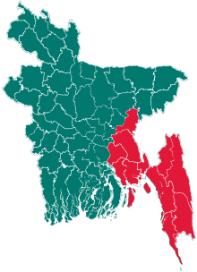
Ashuganj Upazila
| Ashuganj | |
|---|---|
| Upazila | |
| Coordinates: 24°02′N 91°00′E / 24.033°N 91.000°E | |
| Division | Chittagong Division |
| District | Brahmanbaria District |
| Area | |
| • Total | 67.59 km2 (26.10 sq mi) |
| Population (2011 census) | |
| • Total | 180,654 |
| • Density | 2,673/km2 (6,920/sq mi) |
| Time zone | UTC+6 (BST) |
Ashuganj (Bengali: আশুগঞ্জ) is an Upazila of Brahmanbaria District in the Division of Chittagong, Bangladesh.[1]
The area is home to the Port of Ashuganj.
Geography
Ashuganj Upazila (Brahmanbaria district) area 67.59 sq km, located in between 23°51’ and 24°06’ north latitudes and in between 90°53’ and 91°19’ east longitudes. It is bounded by Sarail upazila of Brahmanbaria district on the north, Nabinagar upazila on the south, Brahmanbaria Sadar upazil on the east, Bhairab upazila of Kishoreganj district and Raipura upazila of Narsingdi district on the west.
Ashuganj is called the daughter of the river Meghna. It is a notable river port and industrial city of Bangladesh. Population Total 145828; male 74191, female 71637; Muslim 140119, Hindu 5593, Buddhist 29 and others 87. Water bodies Main river: Meghna. Administration Ashuganj Thana was formed in 1984 and it was turned into an upazila on 25 July 2000. History of the War of Liberation On 14 April 1971 freedom fighters Abul Hossain, Shahjahan, Lance Nayekk A Hai, Subedar Sirajul Islam and Sepahi Abdur Rahman were killed in an encounter with Pak army. During the War of Liberation the Pak army used to torture and kill suspected Bangalis at a slaughter place near Ashuganj Silo. On 9 December 1971 the Pak army destroyed part of Ashuganj-Bhairab railway bridge on the Ashuganj side by dynamite explosion. On the assumption that the Pak army left Ashuganj after destroying railway bridge the allied forces advanced towards Ashuganj to occupy it. As soon as they reached within 50 yards of Asuganj Thermal Power Plant the Pak army launched heavy attack on the 18 Rajput Regiment and killed 70 members of the allied forces including 4 officers. The Pak army left Asuganj on 10 December 1971. Marks of War of Liberation Mass grave 1 (Lalpur Bazar); mass killing site 1 (Ashuganj silo).’ Religious institutions Mosque 205, temple 11, tomb 6. Literacy and educational institutions Average literacy 46.2%, male 47.7%, female 42.7%. Educational institutions: ‘college 4, secondary school 14, primary school 46, madrasa 4, orphanage 41. Noted educational institutions: Feroj Miah Degree College, Bangabandhu Technical College, Abbas Uddin Khan College, Zia Fertilizer Factory School and College, Asuganj AAI High School, Hazi Abdul Jalil High School, Lalpur S. K. Das Chowdhury High School, Tarua Girls’ High School, Talshahor Karimia Senior Madrasa, Araisidha Senior Madrasa, Darul Huda Ebtedaiye Madrasa. Cultural organisation Library 4, other cultural institutions’ 6, theatre 2, press club 1. Newspapers and periodicals Pratasha, weekly Meghna Chitra, Asuganj Sangbad, Ekushey Alo, Kalamer Katha. Main sources of income Agriculture 27.88%, non-agricultural labourer 6.56%, industry 1.79%, commerce 23.55%, transport and communication 2.24%, service 14.10%, construction 2.02%, rent and remittance 3.57% and others 18.29%. Ownership of agricultural land Landowner 53.04%, landless 46.96%; agricultural landowner: urban 49.53% and rural 53.99%. Main crops Paddy, jute, mustard seed, potato, chilli and vegetables. Extinct and nearly extinct crops China, linseed, koun and ground nut. Fisheries, dairies and poultries This upazila has a number of fisheries, dairies and poultries.’ Communication facilities Roads: pucca road 37.50 km, mud road 112; railways’ 7 km, railway station 2. Noted manufactories Asuganj Thermal Power Plant, Zia Fertilizer Factory, etc. Hats, bazars and fairs Total number of hats, bazars and fairs are12, most noted of which are Asuganj Hat, Char Chartala Hat, Talshahor Hat, Tarua Hat and Lalpur Hat, Baishaki Mela (Asuganj), Talshahor Mela and Araisidha Mela. Access to electricity All the unions of the upazila are under electricity net-work; however 57.75% dwelling households have access to electricity. Sources of drinking water Tube-well 88.71%, pond 1.27%, tap 6.62%, and others 3.40%. Sanitation 44.89% of dwelling households (urban 54.33% and rural 42.36%) of the upazila use sanitary latrines and 49.33% of dwelling houses (urban 41.76%, rural and 51.37%) use non-sanitary latrines; 5.78% of households do not have latrine facilities. Health centres Satellite clinic 1, clinic 3, family welfare centre 4. NGO activities asa, proshika, Araisidha Nari Unnayan Kendra, Jagarani Kendra and Grameen Unnayan Kendra. — Banglapedia
Demographics
The total population is 180,654, comprising 85,191 males and 89,074 females and 174,265 Muslims, 6,290 Hindus, 69 Buddhists and 117 people following other religions.
Administration
Ashuganj Upazila has 8 Unions/Wards, 30 Mauzas/Mahallas, and 38 villages.
Durgapur Union: 1. Tazpur 2. Durgapur 3. Bahadurpur. 4. Khariala 5. Bogoir 6.Sohagpur
Power plant
Ashuganj Upazila is known for its power plant which generates much of the electricity for the country especially for the capital city. Ashuganj Fertilizer Ltd is on the other side of Ashuganj. It produces chemical fertilizer for the country. It is especially known as commercial area. Almost 25% electricity supply from Ashugonj Power Station.
Additional information
In Ashugonj, there are more than 500 rice mills which means above 40% rice supply from Ashugonj. Ashugonj Fertilizer is a biggest chemical fertilizer company. There is a Transit in Ashugonj which communicate with India. Ashugonj City is also known as river port. There is also a gas transmission company. The area has experienced severe power shortages but a revamped project is being planned and implemented under Japanese Debt Relief Grant Aid.[2]
See also
References
- ↑ Muhibur Rahim (2012), "Ashuganj Upazila", in Sirajul Islam and Ahmed A. Jamal, Banglapedia: National Encyclopedia of Bangladesh (Second ed.), Asiatic Society of Bangladesh
- ↑ In few days Ashugonj will become a great electrical power supplyer in Bangladesh. "Address Marking the Overhaul of the Contract". Japanese Embassy. Archived from the original on 2007-09-29. Retrieved 2007-07-17.
External links
