Estcourt Station, Maine
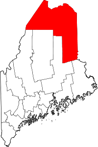
Estcourt Station (elevation: 671 ft (205 m), pop. 4) is a village within the Northwest Aroostook unorganized territory. It is the northernmost point in Maine and New England.
Description
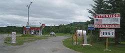
Estcourt Station is located on the Canada–United States border between Maine and Quebec, at the southern end of Lake Pohenegamook in the North Maine Woods region. It derives its name from the adjacent village of Estcourt, Quebec, which is part of the larger municipality of Pohénégamook. The Estcourt Station - Pohénégamook Border Crossing is staffed only several hours daily, usually for processing logging trucks that access Maine's North Woods to haul timber to Quebec saw mills.
The populated part of Estcourt Station is essentially a sliver of the village of Estcourt that was cut off when the international boundary was properly surveyed through the area (see Webster–Ashburton Treaty). It consists of a row of several houses along Rue Frontière, a street on the Quebec side of the border, some of which were built before the survey and which the border now passes through. There is also a general store and a small gas station.
Although the border crossing was constructed for Canadians to enter the North Maine Woods, it is very busy with Canadians who check in at the US border station via Rue de la Frontiere/Estcourt Road (a Canadian road), take the road back to the gas station which is again in US territory, and buy cheaper gasoline there. The station is probably the only one in the eastern United States that displays its prices in Canadian dollars per liter. After the purchase they return on Rue de la Frontiere, check in at the Canadian border station, and officially reenter Canada.[1]
Although the US census reports that four people live in the village, according to a Canada Border Services Agency agent no one lives in Estcourt Station full time as of 2016. A few US residents live in the village during the summer. They must follow the hours of the border control stations, so after 5 pm on Friday cannot leave until 9 am Monday. Anyone attempting to enter the US through Estcourt Station illegally would have to travel on hundreds of miles of private logging roads through the North Maine Woods that are difficult to navigate during spring and summer rains, and almost inaccessible because of snow during the winter;[2] there are no towns or paved roads in the North Maine Woods.[1] Likewise, Estcourt Station uses Quebec's area code 418 for telephone service, and is connected to Hydro-Québec for electricity. The community receives drinking water and other municipal services from Pohénégamook.
Canadian National Railway's transcontinental main line between Halifax and Montreal passes immediately north of Rue Frontière.
Michel Jalbert incident
In October 2002, there was a border incident, described by Secretary of State Colin Powell as "unfortunate",[3][4] that saw a Pohénégamook resident, Michel Jalbert, imprisoned for 35 days in the U.S. after purchasing gas in Estcourt Station outside of the U.S. Customs Service's normal operating hours. U.S. Border Patrol agents said that Jalbert was a convicted felon (convicted in Canada for breaking and entering in 1990 when he was 19 years old) and was in illegal possession of a firearm; he reportedly had a shotgun in the back of his truck – a common occurrence in the area during the partridge hunting season.[5]
See also
Notes
- 1 2 "Chapter 1: Northern Maine and New Hampshire". United Divide: A Linear Portrait of the USA/Canada Border. The Center for Land Use Interpretation. Winter 2015.
- ↑ Williams, Kevin (2016-07-15). "The Incredible Complications of Living Atop the U.S.-Canada Border". Atlas Obscura. Retrieved 16 July 2016.
- ↑ Secretary of State Colin L. Powell and Canadian Minister of Foreign Affairs Bill Graham Press Availability
- ↑ Canfield, Clarke (16 February 2003). "Casual Border Crossing Throws a Life in Limbo". Los Angeles Times. Retrieved 2016-07-17.
- ↑ Clark Canfield, "Trouble at the border"
External links
- The Immigration Case of Michel Jalbert Teaches Larger Lessons
- David Rennie, "Village Customs border on the ridiculous"
Coordinates: 47°27.592′N 69°13.473′W / 47.459867°N 69.224550°W