Aldridge-Brownhills (UK Parliament constituency)
| Aldridge-Brownhills | |
|---|---|
|
Borough constituency for the House of Commons | |
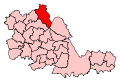 Boundary of Aldridge-Brownhills in West Midlands for the 2005 general election. | |
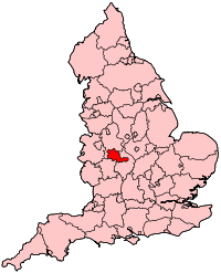 Location of West Midlands within England. | |
| County | West Midlands |
| Population | 76,974 (2011 census)[1] |
| Electorate | 60,251 (December 2015)[2] |
| Current constituency | |
| Created | February 1974 |
| Member of parliament | Wendy Morton (Conservative) |
| Number of members | One |
| Created from | Walsall North and Walsall South |
| Overlaps | |
| European Parliament constituency | West Midlands |
Aldridge-Brownhills /ˈɔːldrɪdʒ

Constituency profile
Geoffrey Edge of the Labour Party served the constituency from its formation in February 1974 until 1979, when it was gained by Richard Shepherd of the Conservative Party; who was to represent the constituency for thirty-six years. In 2014, Richard Shepherd announced he would not stand for re-election at the 2015 general election. Wendy Morton, was selected to replace him as the Conservative candidate, and secured it with a safe majority of 11,723 votes.
Boundaries
1974-1983: The Urban District of Aldridge-Brownhills.
1983-2010: The Metropolitan Borough of Walsall wards of Aldridge Central and South, Aldridge North and Walsall Wood, Brownhills, Hatherton Rushall, Pelsall, and Streetly.
2010–present: The Metropolitan Borough of Walsall wards of Aldridge Central and South, Aldridge North and Walsall Wood, Brownhills, Pelsall, Rushall-Shelfield, and Streetly.
Aldridge-Brownhills constituency was created in 1974 from parts of the seats of Walsall North and Walsall South. It is one of three constituencies covering the Metropolitan Borough of Walsall. It covers the north-east and east of the borough. When held by the Labour Party the Constituency included most of Pheasey, a ward of the same name, then a stronger area for Labour than much of the rest, which was moved into Walsall South to account for population expansion in this constituency.
Members of Parliament
| Election | Member[3] | Party | ||
|---|---|---|---|---|
| Feb 1974 | Geoffrey Edge | Labour | ||
| 1979 | Sir Richard Shepherd |  |
Conservative | |
| 2015 | Wendy Morton |  |
Conservative | |
Elections
Elections in the 2010s
| Party | Candidate | Votes | % | ± | |
|---|---|---|---|---|---|
| Conservative | Wendy Morton | 26,317 | 65.4 | +13.4 | |
| Labour | John Fisher | 12,010 | 29.8 | +7.5 | |
| Liberal Democrat | Ian Garrett | 1,343 | 3.3 | -0.1 | |
| Monster Raving Loony | Mark Beech | 565 | 1.4 | +0.9 | |
| Majority | 14,307 | 35.6 | |||
| Turnout | 40,235 | 67.5 | |||
| Conservative hold | Swing | ||||
| Party | Candidate | Votes | % | ± | |
|---|---|---|---|---|---|
| Conservative | Wendy Morton | 20,558 | 52.0 | −7.3 | |
| Labour | John Fisher | 8,835 | 22.4 | +2.6 | |
| UKIP | Anthony Thompson | 7,751 | 19.6 | +19.6 | |
| Liberal Democrat | Ian Garrett | 1,330 | 3.4 | −14.3 | |
| Green | Martyn Curzey | 826 | 2.1 | −0.1 | |
| Monster Raving Loony | Mark Beech | 197 | 0.5 | +0.5 | |
| Majority | 11,723 | 29.7 | |||
| Turnout | 39,497 | 65.8 | |||
| Conservative hold | Swing | -4.9% | |||
| Party | Candidate | Votes | % | ± | |
|---|---|---|---|---|---|
| Conservative | Richard Shepherd | 22,913 | 59.3 | +11.1 | |
| Labour | Ashiq Hussain | 7,647 | 19.8 | −12.9 | |
| Liberal Democrat | Ian Jenkins | 6,833 | 17.7 | +5.8 | |
| Green | Karl Macnaughton | 847 | 2.2 | +2.2 | |
| Christian | Sue Gray | 394 | 1.0 | +1.0 | |
| Majority | 15,256 | 39.5 | |||
| Turnout | 38,644 | 65.1 | |||
| Conservative hold | Swing | +12.0 | |||
Elections in the 2000s
| Party | Candidate | Votes | % | ± | |
|---|---|---|---|---|---|
| Conservative | Richard Shepherd | 18,744 | 47.4 | −2.8 | |
| Labour | John D. Phillips | 13,237 | 33.5 | −6.7 | |
| Liberal Democrat | Roy M. Sheward | 4,862 | 12.3 | +3.7 | |
| BNP | William R. Vaughan | 1,620 | 4.1 | N/A | |
| UKIP | Graham Eardley | 1,093 | 2.8 | N/A | |
| Majority | 5,507 | 13.9 | |||
| Turnout | 39,556 | 64.0 | +3.4 | ||
| Conservative hold | Swing | +2.0 | |||
| Party | Candidate | Votes | % | ± | |
|---|---|---|---|---|---|
| Conservative | Richard Shepherd | 18,974 | 50.2 | +3.0 | |
| Labour | Ian D. Geary | 15,206 | 40.2 | −1.5 | |
| Liberal Democrat | Monica Howes | 3,251 | 8.6 | −2.6 | |
| Socialist Alliance | John D. Rothery | 379 | 1.0 | N/A | |
| Majority | 3,768 | 10.0 | |||
| Turnout | 37,810 | 60.6 | −13.6 | ||
| Conservative hold | Swing | +2.25 | |||
Elections in the 1990s
| Party | Candidate | Votes | % | ± | |
|---|---|---|---|---|---|
| Conservative | Richard Shepherd | 21,856 | 47.1 | −7.2 | |
| Labour | Janos Toth | 19,330 | 41.7 | +8.4 | |
| Liberal Democrat | Celia M. Downie | 5,184 | 11.2 | −1.2 | |
| Majority | 2,526 | 5.4 | |||
| Turnout | 46,370 | 74.3 | -8.3 | ||
| Conservative hold | Swing | +7.8 | |||
| Party | Candidate | Votes | % | ± | |
|---|---|---|---|---|---|
| Conservative | Richard Shepherd | 28,431 | 54.3 | +1.0 | |
| Labour | Neil E. Fawcett | 17,407 | 33.3 | +4.9 | |
| Liberal Democrat | Stewart Reynolds | 6,503 | 12.4 | −5.9 | |
| Majority | 11,024 | 21.1 | −4.0 | ||
| Turnout | 52,341 | 82.6 | +2.8 | ||
| Conservative hold | Swing | −2.0 | |||
Elections in the 1980s
| Party | Candidate | Votes | % | ± | |
|---|---|---|---|---|---|
| Conservative | Richard Shepherd | 26,434 | 53.4 | +2.7 | |
| Labour | Clive Duncan | 14,038 | 28.3 | +3.4 | |
| Social Democratic | Glynn Betteridge | 9,084 | 18.3 | −6.1 | |
| Majority | 12,936 | 25.1 | -0.7 | ||
| Turnout | 49,556 | 79.8 | +1.6 | ||
| Conservative hold | Swing | −0.4 | |||
| Party | Candidate | Votes | % | ± | |
|---|---|---|---|---|---|
| Conservative | Richard Shepherd | 24,148 | 50.7 | +0.4 | |
| Labour | R.T. Burford | 11,864 | 24.9 | −14.5 | |
| Social Democratic | P.G. Gunn | 11,599 | 24.4 | N/A | |
| Majority | 12,284 | 25.8 | +15.0 | ||
| Turnout | 47,611 | 78.3 | −4.2 | ||
| Conservative hold | Swing | + 7.45 | |||
Elections in the 1970s
| Party | Candidate | Votes | % | ± | |
|---|---|---|---|---|---|
| Conservative | Richard Shepherd | 26,289 | 50.3 | +11.9 | |
| Labour | Geoffrey Edge | 20,621 | 39.4 | −4.1 | |
| Liberal | John Aldridge | 5,398 | 10.3 | −7.4 | |
| Majority | 5,668 | 10.8 | |||
| Turnout | 52,308 | 82.5 | +2.8 | ||
| Conservative gain from Labour | Swing | +9.8 | |||
| Party | Candidate | Votes | % | ± | |
|---|---|---|---|---|---|
| Labour | Geoffrey Edge | 21,403 | 43.5 | +4.8 | |
| Conservative | A.J.M. Teacher | 18,884 | 38.4 | +0.5 | |
| Liberal | J.A. Crofton | 8,693 | 17.7 | −5.7 | |
| More Prosperous Britain | Tom Keen | 210 | 0.4 | N/A | |
| Majority | 2,519 | 5.1 | |||
| Turnout | 49,190 | 79.7 | −3.5 | ||
| Labour hold | Swing | +3.9 | |||
| Party | Candidate | Votes | % | ± | |
|---|---|---|---|---|---|
| Labour | Geoffrey Edge | 19,642 | 38.7 | N/A | |
| Conservative | Patricia Hornsby-Smith | 19,276 | 37.9 | N/A | |
| Liberal | J.A. Crofton | 11,883 | 23.4 | N/A | |
| Majority | 366 | 0.7 | N/A | ||
| Turnout | 50,801 | 83.2 | N/A | ||
| Labour win (new seat) | |||||
See also
External links
Notes and references
- Notes
- ↑ A borough constituency (for the purposes of election expenses and type of returning officer)
- ↑ As with all constituencies, the constituency elects one Member of Parliament (MP) by the first past the post system of election at least every five years.
- References
- ↑ "Usual Resident Population, 2011". Neighbourhood Statistics. Office for National Statistics. Retrieved 25 January 2015.
- ↑ "Electorate Figures - Boundary Commission for England". 2011 Electorate Figures. Boundary Commission for England. 4 March 2011. Archived from the original on 6 November 2010. Retrieved 13 March 2011.
- ↑ Leigh Rayment's Historical List of MPs – Constituencies beginning with "A" (part 1)
- ↑ "Statement of persons nominated and notice of poll" (DOC). Walsall Metropolitan Borough Council. Retrieved 5 June 2017.
- ↑ "Election Data 2015". Electoral Calculus. Archived from the original on 17 October 2015. Retrieved 17 October 2015.
- ↑ "Election Data 2010". Electoral Calculus. Archived from the original on 26 July 2013. Retrieved 17 October 2015.
- ↑ "Election Data 2005". Electoral Calculus. Archived from the original on 15 October 2011. Retrieved 18 October 2015.
- ↑ "Election Data 2001". Electoral Calculus. Archived from the original on 15 October 2011. Retrieved 18 October 2015.
- ↑ "Election Data 1997". Electoral Calculus. Archived from the original on 15 October 2011. Retrieved 18 October 2015.
- ↑ "Election Data 1992". Electoral Calculus. Archived from the original on 15 October 2011. Retrieved 18 October 2015.
- ↑ "1992 general election results". Election 1992. Politics Resources. Retrieved 6 December 2010.
- ↑ "Election Data 1987". Electoral Calculus. Archived from the original on 15 October 2011. Retrieved 18 October 2015.
- ↑ "Election Data 1983". Electoral Calculus. Archived from the original on 15 October 2011. Retrieved 18 October 2015.