Anand district
| Anand district | |
|---|---|
| district | |
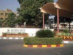 Entrance of the AMUL Dairy | |
| Nickname(s): Charotar | |
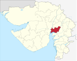 Location of district in Gujarat | |
| Coordinates: 22°34′N 72°56′E / 22.57°N 72.93°ECoordinates: 22°34′N 72°56′E / 22.57°N 72.93°E | |
| Country |
|
| State | Gujarat |
| Area | |
| • Total | 3,204 km2 (1,237 sq mi) |
| Population (2011) | |
| • Total | 2,092,745 |
| • Rank | 14th in state |
| • Density | 650/km2 (1,700/sq mi) |
| Languages | |
| • Official | Gujarati, Hindi |
| Time zone | UTC+5:30 (IST) |
| Vehicle registration | GJ-23[1] |
| Website | https://ananddp.gujarat.gov.in/Anand |
Anand District is an administrative district of Gujarat state in western India and is popularly known as Charotar.[2] It was carved out of the Kheda district in 1997. Anand is the administrative headquarters of the district. It is bounded by Kheda District to the north, Vadodara District to the east, Ahmedabad District to the west, and the Gulf of Khambhat to the south. Major towns are Khambhat, Karamsad, Tarapur, Petlad and Sojitra.
Demographics
According to the 2011 census Anand district has a population of 2,090,276[3] (With total Males 1,088,253[4] and total Females 1,002,023),[4] roughly equal to the nation of Macedonia[5] or the US state of New Mexico.[6] This gives it a ranking of 219th in India (out of a total of 640).[3] The district has a population density of 711 inhabitants per square kilometre (1,840/sq mi) .[3] Its population growth rate over the decade 2001-2011 was 12.57%.[3] Anand has a sex ratio of 921 females for every 1000 males,[3] and a literacy rate of 85.79%[3] (Males 93.23%[4] and Females 77.76%).[4]
Economy
Economy of the Anand is very vibrant which ranges from farming to big scale industries. Major crops includes Tobacco and Banana. Anand is home to the famous AMUL Dairy. Vitthal Udhyog Nagar, very big industrial belt is located on the outskirts of the city. Many famous industries including ELECON, The Charotar Iron Factory(est.1938), Warm Steam, Milcent and Atlanta Electrics are situated in this industrial belt. Amul is an Indian dairy cooperative, based at Anand in the state of Gujarat, India. Amul spurred India's White Revolution, which made the country the world's largest producer of milk and milk products. Amul is the largest food brand in India and has ventured into markets overseas.
Administrative divisions
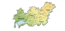
Anand District is administratively divided into eight talukas or subdistricts: Anand, Anklav, Borsad, Khambhat, Petlad, Sojitra, Tarapur, and Umreth.[7]
Points of interest
- Anand City[8] - birthplace of Tribhuvandas Patel, Founder of Anand Milk Union Limited and Cooperative movement, Milk City.
- Amul - Origin of Operation Flood, the White Revolution of India
- Anand Agricultural University[9]
- Karamsad - birthplace of Sardar Patel. Famous for Pramukh Swami Medical College.
- Khambhat - a historic and ancient port in the bay of Khambhat, known for its trade with foreign countries.
- Dakor - This is not in Anand district but in the nearby Kheda district.Hindu temple of Lord Ranchodrai a form of Krishna.
- Pavagadh Fort - This is not in Anand district but in the nearby Panchmahal district. Ruins of the fort have been designated a world heritage site by UNESCO.
- Bhadran - was given nickname "Paris of Gaekwad state" due to its prosperity and civil works carried by Maharaja Sayajirao Gaekwad III about one century ago.
- Vadtal
- Sardar Patel University- One of the well known universities in India. Located in Vallabh Vidyanagar in Anand District. The University is having Community Radio Station ( Radio Campus) operating at 90.4 MHz frequency of FM band.
See also
References
| Wikimedia Commons has media related to Anand district. |
- ↑ "RTO Gujarat Codes". Retrieved 2016-05-28.
- ↑ "History of Anand District". Gujarat Government. Retrieved 9 October 2012.
- 1 2 3 4 5 6 "District Census 2011". Census2011.co.in. 2011. Retrieved 2011-09-30.
- 1 2 3 4 "Anand District Panchayat". ananddp.gujarat.gov.in. 2016. Retrieved 2016-05-28.
- ↑ US Directorate of Intelligence. "Country Comparison:Population". Retrieved 2011-10-01.
Macedonia 2,077,328 July 2011 est.
- ↑ "2010 Resident Population Data". U. S. Census Bureau. Archived from the original on 2013-10-19. Retrieved 2011-09-30.
New Mexico - 2,059,179
- ↑ "Gujarat Administrative Divisions 2011" (PDF). Office of The Registrar General & Census Commissioner, Ministry of Home Affairs, Government of India. Archived (PDF) from the original on 26 October 2011.
- ↑
- ↑
Places adjacent to Anand district | |
|---|---|
| Topics |  | |
|---|---|---|
| Regions of Gujarat | ||
| Districts | ||
| Major cities | ||
| Ecoregions | ||
| Economy |
| |
| ||