Agüimes
| Agüimes | |
|---|---|
| Municipality | |
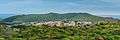
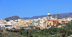 Panorama of Agüimes | |
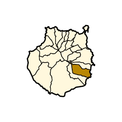 Municipal location in Gran Canaria | |
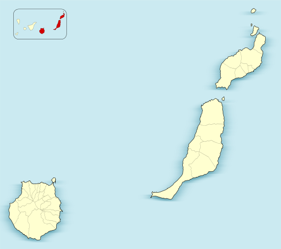 Agüimes Location in the province of Las Palmas  Agüimes Agüimes (Canary Islands)  Agüimes Agüimes (Spain, Canary Islands) | |
| Coordinates: 27°54′N 15°27′W / 27.900°N 15.450°WCoordinates: 27°54′N 15°27′W / 27.900°N 15.450°W | |
| Country |
|
| Autonomous Region | Canary Islands |
| Province | Las Palmas |
| Island | Gran Canaria |
| Area[1] | |
| • Total | 79.28 km2 (30.61 sq mi) |
| Elevation | 275 m (902 ft) |
| Population (2013)[2] | |
| • Total | 30,214 |
| • Density | 380/km2 (990/sq mi) |
| Time zone | UTC+0 (GMT) |
| Climate | BWh |
| Website |
www |
Agüimes is a Spanish town and municipality in the eastern part of the island of Gran Canaria in the Las Palmas province in the Canary Islands.
Presentation
Agüimes is situated 5 km from the coast, and 26 km south of the island capital Las Palmas. The GC-1 motorway passes east of the town.
The population is 30,214 (2013),[2] and the area is 79.28 km².[1] The elevation is 275 m.
Evolution of the population
| Year | Population |
|---|---|
| 1991 | 16,156 |
| 1996 | 18,284 |
| 2001 | 20,124 |
| 2002 | 22,567 |
| 2003 | 23,572 |
| 2004 | 24,460 |
| 2013 | 30,214 |
Climate
| Climate data for Agüimes, Las Palmas (altitude 150 m, data of 1953-1965) | |||||||||||||
|---|---|---|---|---|---|---|---|---|---|---|---|---|---|
| Month | Jan | Feb | Mar | Apr | May | Jun | Jul | Aug | Sep | Oct | Nov | Dec | Year |
| Average high °C (°F) | 18.5 (65.3) |
19.4 (66.9) |
20.8 (69.4) |
21.0 (69.8) |
23.0 (73.4) |
24.0 (75.2) |
27.4 (81.3) |
27.3 (81.1) |
25.8 (78.4) |
24.1 (75.4) |
21.2 (70.2) |
18.8 (65.8) |
22.6 (72.7) |
| Daily mean °C (°F) | 14.8 (58.6) |
15.2 (59.4) |
16.3 (61.3) |
16.5 (61.7) |
18.4 (65.1) |
19.2 (66.6) |
22.6 (72.7) |
22.4 (72.3) |
21.6 (70.9) |
20.2 (68.4) |
17.7 (63.9) |
15.4 (59.7) |
18.4 (65.1) |
| Average low °C (°F) | 11.1 (52) |
11.0 (51.8) |
11.8 (53.2) |
12.0 (53.6) |
13.9 (57) |
14.5 (58.1) |
17.8 (64) |
17.6 (63.7) |
17.4 (63.3) |
16.4 (61.5) |
14.1 (57.4) |
12.0 (53.6) |
14.1 (57.4) |
| Average precipitation mm (inches) | 41 (1.61) |
37 (1.46) |
11 (0.43) |
5 (0.2) |
4 (0.16) |
1 (0.04) |
0 (0) |
0 (0) |
7 (0.28) |
32 (1.26) |
89 (3.5) |
62 (2.44) |
289 (11.38) |
| Source: Worldwide Bioclimatic Classification System[3] | |||||||||||||
Economy
The major growth of the last few years has been the creation of a huge industrial estate on flat land once covered by tomato plantations. This has brought new jobs and industries into the area and has spurred the development of a new purpose-built port which is due to open in 2007.
Tourism
The district was not at one time a major tourist destination, but after the careful restoration of the old town, this has become the best example of a traditional Canarian hill town. The streets of the old town exude a gentle, relaxed, timeless atmosphere, and the carefully positioned street statues and sculptures add a series of surprises to a visit to the old town. The local plan for 'rural tourism' has led to the development of other small visitor centres on the district, the biggest of which is in the Guayadeque ravine. This area has many cave houses dating back hundreds of years, and a complete village excavated into the hillside, still occupied today, with its own cave chapel, cave bar and cave restaurants.
Sports
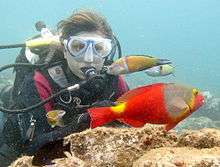
Sporting activities are also very important in the area, with its windsurfing and scuba diving recognized as "world class". One round of the annual Professional Windsurfers Association (PWA) windsurfing tour is held at the international windsurfing centre at Pozo Izquierdo every year, and the whole of the coast in this area can provide challenging conditions at any time of the year.
The main area for scuba diving in Gran Canaria is in the area known as the 'El Cabrón' marine reserve, next to the town of Arinaga. The diving in this area includes caves, arches, walls and volcanic reefs where an extremely wide range of sub-tropical marine species can be found, from tiny seahorses up to rays and angel sharks.
| Wikimedia Commons has media related to Aguimes. |
Heritage sites
The municipality's territory is rich in historical sites, among which the El Maipés necropolis in Agaete is a well-known site. The caves and granaries of the Audience site in Temisas and the caves and hillocks in Avila have been declared Sites of cultural interest in 2016.[4]
Gallery
 Aguimes 2016
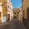 Aguimes 2016
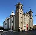 Templo Parroquial de San Sebastián
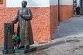 Aguimes 2016
 Aguimes 2016
See also
References
- 1 2 Instituto Canario de Estadística, area
- 1 2 Instituto Canario de Estadística Archived April 22, 2014, at the Wayback Machine., population
- ↑ "Worldwide Bioclimatic Classification System - Esp. Las Palmas - Aguimes -Las Palmas".
- ↑ (in Spanish) Notice on the caves and granaries of the Audience site in Temisas, and on the caves and hillocks in Avila" (Cuevas y Graneros de la Audiencia de Temisas y Cuevas y Morros de Ávila). Municipality of Aguimes - Notice, July 25, 2016.
External links
- Agüimes.es Website of the local council (Ayuntamiento de Agüimes)
- Patinegro Local environmental action group Patinegro
Places adjacent to Agüimes | |
|---|---|