2018 Sulawesi earthquake and tsunami
  | |
| UTC time | 2018-09-28 10:02:44 |
|---|---|
| ISC event | 612780996 |
| USGS-ANSS | ComCat |
| Local date | 28 September 2018 |
| Local time | 18:02:44 WITA (Indonesia Central Standard Time) |
| Magnitude | Mw 7.5 |
| Depth | 10.0 km |
| Epicentre | 0°10′41″S 119°50′24″E / 0.178°S 119.840°ECoordinates: 0°10′41″S 119°50′24″E / 0.178°S 119.840°E |
| Fault | Palu-Koro fault |
| Type | Strike-slip |
| Max. intensity | IX (Violent) |
| Tsunami | Yes (highest 7 m (23 ft) in Donggala Regency)[1] (or 15 m (49 ft) in Wani) [2] |
| Landslides | Yes |
| Foreshocks | Mw6.1, M5.4, M5.0 |
| Aftershocks | Five M≥5.5 |
| Casualties | |
On 28 September 2018, a shallow, large earthquake struck in the neck of the Minahasa Peninsula, Indonesia, with its epicentre located in the mountainous Donggala Regency, Central Sulawesi. The magnitude 7.5 quake was located 77 km (48 mi) away from the provincial capital Palu and was felt as far away as Samarinda on East Kalimantan and also in Tawau, Malaysia.[6] This event was preceded by a sequence of foreshocks, the largest of which was a magnitude 6.1 tremor that occurred earlier that day.[7]
Following the mainshock, a tsunami alert was issued for the nearby Makassar Strait, but was called off half an hour later.[8] A localised tsunami struck Palu, sweeping shore-lying houses and buildings on its way. The combined effects of the earthquake and tsunami led to the deaths of at least 2,088 people.[3][9] This makes it the deadliest earthquake to strike the country since the 2006 Yogyakarta earthquake, as well as the deadliest earthquake worldwide so far in 2018, surpassing the previous earthquake that struck Lombok a few months earlier, killing more than 600.[10] The Indonesian Agency for Meteorology, Climatology and Geophysics (BMKG) confirmed that a tsunami had been triggered, with its height reaching an estimated maximum of 4 to 7 metres (13 to 23 ft), striking the settlements of Palu, Donggala and Mamuju along its path.[11]
The earthquake caused major soil liquefaction in areas in and around Palu.[12] In two locations this led to mudflows in which many buildings became submerged causing hundreds of deaths with many more missing.[13]
Tectonic setting
Sulawesi lies within the complex zone of interaction between the Australian, Pacific, Philippine and Sunda Plates in which many small microplates are developed.[7] The main active structure onshore in the western part of Central Sulawesi is the left-lateral NNW-SSE trending Palu-Koro strike-slip fault that forms the boundary between the North Sula and Makassar blocks.[14] The rate of slip along this fault is estimated to be in the range 30–40 mm per year.[15] At Palu, there are several parallel fault strands defining the margins of a pull-apart basin, each of which take up some of the overall slip.[14] Several major earthquakes have been attributed to movement on this fault since 1900 and three larger events in the last 2,000 years have been deduced from studies of the fault zone. In 2016 a study recognised this fault as representing the greatest seismic risk in eastern Indonesia.[16]
Earthquake

Foreshocks
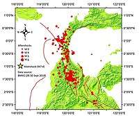
The mainshock was preceded by a sequence of foreshocks starting about three hours earlier with a M6.1 event, followed by several others, all located in the area immediately south of the mainshock epicentre.[17]
The first foreshock occurred at 15:00 WITA (Indonesia Central Standard Time). The earthquake struck at a shallow depth of 10 km with a magnitude of 5.9 ML(BMKG). The USGS registered the size of the quake as 6.1 Mw. Strong shaking was felt in Donggala. At least 1 person was killed by fallen debris while 10 others were injured. Authorities confirmed that dozens of structures were either damaged or destroyed in the quake.[18]
Mainshock
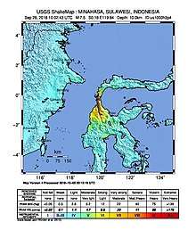
The mainshock magnitude was initially reported as M7.7 by both the USGS and BMKG. The USGS later revised their estimate to M7.5. The focal mechanism of the earthquake showed that it was caused by strike-slip faulting on faults trending either roughly north-south or west-east. Further analysis of seismic waveforms suggests that a fault trending north-south gives a better fit.[19] The earthquake was caused by movement on the Palu-Koro fault.[20] Geodetic evidence suggests that about 150 km of the fault ruptured.[7]
The mainshock occurred at 18:02 WITA, during rush hour traffic. The shaking was felt as far away as Samarinda, the capital of East Kalimantan, to the west and Makassar in the south.[21] It was also felt in several parts in Gorontalo, located on the north and was also felt in Tawau, Malaysia. Violent shaking was reported in Donggala and Palu. Blackouts occurred throughout the area and telecommunications went down. The state-owned Telkomsel reported that more than 500 wireless communication towers had been damaged by the earthquake.[22]
Indonesian authorities confirmed that no one had been able to contact a single person from Donggala, the closest town to the epicentre.[23] As of 1 October, contacts were still hampered by downed telecommunication lines.
Aftershocks
The mainshock was followed by a series of aftershocks, with 14 of M≥5.0 in the first 24 hours.[24] Since then, a total of 150 aftershocks have struck the region.[25]
Intensity
The earthquake was felt over a wide area. Noticeable shaking, ranging from II-III on the Mercalli intensity scale, was reported in Samarinda, Makassar and Tawau. The strongest shaking was felt in Donggala Regency where a maximum intensity of IX (violent) was recorded. The maximum intensity in Palu, the provincial capital of Central Sulawesi, was at VII (strong). According to the Indonesian Agency for the Assessment and Application for Technology (BPPT), energy released by the quake was 200 times to that released in the 1945 nuclear bombing of Hiroshima. Analysis also showed that the shoreline which was located near the rupture in Palu and Donggala had a decrease on its height. Height drops of 0.5–1 meter were recorded, while an increase of height of around 0.3 cm was recorded in Banawa.[26]
Tsunami
A tsunami warning was issued in Palu and Donggala at 18:07 WITA.[20] Warnings were sent via SMS by the Indonesian Ministry of Communication and Information.[27] Residents of Donggala were told to expect tsunamis with heights of 0.5 to 3 metres, while residents in Palu were told to expect tsunamis with heights of less than 0.5 metres. The tsunami, however, struck higher than expected. Residents of Palu reported waves with heights of more than 2 metres while several others stated that the waves managed to reach the second floor.[28]
Indonesian officials calculated the estimated time of arrival of the tsunami. Calculations suggested that the tsunami would arrive in Palu approximately 20 minutes after the earthquake. Around 18:27 WITA, the Indonesian meteorological agency (BMKG) in Mamuju detected tsunamis. A tsunami warning was issued, and later lifted. The BMKG claimed the warning was lifted after the tsunami had struck, but the timing is unclear, and the agency was criticized on social media.[20][29][30]
As Palu was located at the end of a narrow bay, the tsunami's force was intensified when the waters entered.[31] Officials confirmed that the waves that struck Palu had actually reached a height of 5 metres, with some as nearly as high as 6 metres.[32]
The tsunami caught geologists by surprise. Since the earthquake was a strike-slip earthquake, the tsunami was expected to be at a low height, with a maximum height of approximately 2 metres. During a strike-slip earthquake, the movements of the crusts were largely in horizontal motion while most tsunamis occurred in earthquakes with vertical motion. One explanation is that the earthquake triggered underwater landslides, causing the tsunami.[33]
Damage

More than 70,000 houses are reported to be damaged, forcing tens of thousands of people to live in shelters and tents.[34] In Palu, the capital of Central Sulawesi, a mosque[35] and a major section of the Antapura Hospital collapsed. Palu's Tatura Mall, one of the oldest shopping centres in Palu, collapsed, trapping dozens of people.[36] An eight-story hotel, identified as the Roa-Roa Hotel, had also collapsed,[37] trapping numerous hotel guests, several of whom were participants of the Palu's annual paragliding festival. At the time of the earthquake, 76 of the 80 bedrooms of the hotel were occupied.[38]
Palu's Mutiara SIS Al-Jufrie Airport was forced to close as large cracks, one of which was 500 meters long, had been formed on the runway. Airport officials confirmed that the navigation system was damaged and the control tower of the airport collapsed. An air traffic controller, who was watching the take-off roll of a Batik Air plane during the earthquake, was killed. The airport was reopened for limited operation on 29 September 2018. Hundreds of passengers were stranded at the airport. Normal operation returned on service on 30 September.[39]
Authorities confirmed that numerous settlements and residential areas, including more than a thousand homes, had been destroyed by the earthquake and tsunami.[40] The tsunami also caused major damage to ports in Palu. In Pantoloan Harbour, a Quay crane collapsed and was swept by the tsunami. In Wani Harbour, structural damage was reported, while Ogoamas Harbour moved 3 cm to its right due to the earthquake.[41]
_-_panoramio.jpg)
Officials confirmed that Palu's iconic bridge, the Kuning Ponulele Bridge (Jembatan Palu IV), which was also the first arch bridge in Indonesia,[42] was destroyed by the earthquake and the ensuing tsunami.[43] Roads to and from the city, connecting it to Makassar and Poso, were also severely damaged. There were also reports of landslides.[44]
Communication to the affected area was severely hampered, with President Joko Widodo being initially unable to contact governor Longki Djanggola.[45] Local hospitals were damaged, with the Director of the Palu Undata Hospital opting to treat victims outside of the hospital and made a public plea for tents, medicine, canvas, and nurses.[46] A warden for a prison in Palu reported that more than half of its 560 inmates fled in panic as the prison walls collapsed.[47]
In the immediate aftermath of the earthquake, prisoners in the Donggala Penitentiary in Central Sulawesi rioted and set the prison on fire as they demanded to be met by their families. At least 100 prisoners managed to escape. The prison reportedly suffered severe damage.[48][49]
Major soil liquefaction was reported in Sigi Regency, which was located south of Palu. Numerous eyewitnesses stated that the total amount of liquid released by the soil was so immense that buildings and structures were swept away. There were also reports that a whole village was gone.[50]
Mudflows
Parts of Central Sulawesi have been hit by major mudflows following the earthquake as a result of liquefaction. The most affected areas are the Petobo sub-district in southern Palu and the village of Balaroa, just outside the city, both locations some distance from the coast.[13]
In Petobo at least 34 Indonesian students from a Bible camp were killed, but it is suspected that many others are dead.[51] Most of the districts 744 houses have been destroyed and 200 bodies have so far been retrieved.[13]
Balaroa almost disappeared as the ground collapsed, with most of the village's 1,747 houses sinking into the mud. Of the 2,000 inhabitants, 600 are known to have died, while more than a thousand are still missing.[13]
Casualties
The 6.1 magnitude foreshock occurred at 15:00 local time while the 7.5 magnitude earthquake on the evening caused severe destruction in Palu, Donggala and Sigi, destroying several homes and hospitals, a shopping centre, a mosque, a church, a hotel and a road bridge.[52] At least 2,088 people are confirmed dead after the disaster[3] and more than 10,000 others injured.[53]
Palu
On the evening of 28 September, earthquakes followed by a tsunami struck the city. The first place that was hit by the tsunami was the beach where a festival named Festival Pesona Palu Nomoni was ongoing. The majority of the partygoers were later recovered dead from the beach and the sea. Several others were injured.[54]
Local residents stated that many bodies were lined and laid on the side of the street and many were also found on the shoreline. The Vice President of Indonesia Jusuf Kalla announced that the death toll will likely rise to more than a thousand, added that he based his statements on his past experience during the 2004 Indian Ocean earthquake and tsunami.[55]
On 30 September 2018, officials from the Indonesian National Search and Rescue Agency reported that at least 100 people were trapped inside Tatura Mall, the oldest and the largest shopping center in Palu.[56] Another 50–60 people were still trapped inside the rubble of the 8 story Roa-Roa Hotel, many of whom were heard crying for help.[57] Officials admitted that lack of heavy equipment hampered the search and rescue effort.[58]
Indonesian authorities stated that at least 200 survivors in Palu will be evacuated with a Hercules C-130 to Makassar, some for further medical treatment.[59] According to officials, nearly 17,000 people in Palu had been displaced by the earthquake and tsunami. The Head of Data, Information and Public Relations Center of Indonesian National Board for Disaster Management, Sutopo Purwo Nugroho, stated that around 2.4 million people were affected by the earthquake and tsunami.[60]
Donggala
From 28 to 29 September, the victims from Donggala could not be accounted for due to limited access and downed communication lines. In the next days, emergency workers arrived in the city. The impact on the city was deadly, causing many victims.[54]
Sigi, Baleroa and Petobo
The Indonesian National Board for Disaster Management stated that Sigi Regency was among the area with the most casualties.[61] Reports from Petobo revealed that "dozens of people" were killed by the earthquake, including the 34 students from a Bible camp that died after being struck by a mudflow. There were also reports of "massive liquefaction" which caused homes to be swept away[50]. Officials also reported that numerous earthquakes with magnitude of over 5.0 had struck Sigi continuously, damaging more buildings and structures.[61]
Response
Indonesian President Joko Widodo immediately ordered the Coordinating Minister of Politics, Legal and Security Affairs Wiranto to coordinate the relief efforts in the affected areas. He had called the commander of the Indonesian National Armed Forces Hadi Tjahjanto for the emergency responses. He also stated that he will declare the earthquake and tsunami in Palu as a major disaster. He added that he had tried to call the governor of Central Sulawesi, whose office is in the city of Palu. However, due to the downed telecommunication lines, the calls weren't able to be received. He later appealed for calm and urged people not to panic in response to the disaster.[62]
Joko Widodo and several other prominent government officials, including head of the Indonesian National Search and Rescue Agency Bambang Soelistyo, commander of the Indonesian National Armed Forces Hadi Tjahjanto and some of his ministers will visit the hardest hit areas on 30 September.[63]
Coordinating Minister of Politics and Legal Affairs Wiranto stated that his Ministry will conduct a joint search and rescue effort with the Indonesian National Search and Rescue Agency, the Indonesian National Armed Forces, the Indonesian BMKG and the Indonesian National Board for Disaster Management. Several personnel had been immediately deployed to the disaster zone. He also added that make-shift hospitals, shelters and crisis centres will be set up in multiple locations.[64]
The Indonesian Ministry of Communication and Information deployed at least 30 satellites phone to recover the communication in Palu.[27] On 30 September 2018, the Ministry deployed 100 satellite phones to Sulawesi.
Helicopters and ships were deployed from Borneo by the Indonesian National Search and Rescue Agency. Regional search and rescue agency from Boolang Mongondow, Kendari and Makassar also sent dozens of personnel to assist the rescue efforts in Sulawesi.[65] Makassar Red Cross stated that they will send 12 personnel and ambulances to the affected areas.[66]Head of the Indonesian National Search and Rescue Agency Muhammad Syaugi stated that he had ordered the personnel from the regional search and rescue agency in Gorontalo, Banjarmasin and Balikpapan to assist the rescue operation in Palu[58].
Food shortage was reported, and survivors screamed for foods outside a military command in Palu.[67]
International and private
A spokesperson for the Australian Department of Foreign Affairs and Trade, said that, while no official request for assistance had been made as of 29 September, it was ready to assist if international assistance were required. A UN spokesperson echoed this statement, and was in contact with the Government of Indonesia.[47] On 30 September President Joko Widodo agreed to accept international and private sector aid.[68]
On 30 September 2018, South Korea's Ministry of Foreign Affairs announced that Korean government will provide $ 1 million in humanitarian assistance and also consider dispatching Korea Disaster Relief Team(KDRT) after consultation with the relevant ministries and the Indonesian government. On 2 October 2018, Singapore Defence Minister Dr Ng Eng Hen announced that two Republic of Singapore Air Force C-130s were en-route to Sulawesi to deliver humanitarian supplies–bottled water, meals, tents and medical supplies. As requested by the Indonesian Armed Forces (TNI), both aircraft will stay in Sulawesi to transport survivors to other cities of Indonesia that have better facilities to cope, as the tsunami destroyed much of the existing town.[69] The Foreign Affairs Minister of New Zealand, Winston Peters, reported the country would contribute $1.6 million to assist in emergency response efforts, with support and contributions to the International Federation of the Red Cross and Red Crescent.[70] Malaysia, through its Deputy Prime Minister Wan Azizah Wan Ismail, had telephoned Indonesian Vice-President Jusuf Kalla to inform him of the dispatchment of the SMART team for search-and-rescue efforts along with a donation of RM500,000 in aid for the victims.[71] Taiwan also dispatched 36 specialists and six sniffer dogs from the New Taipei City Fire Department of the National Fire Agency (NFA) to assist in rescue efforts together with the donation of supplies, a medical team and 10,000 blankets for the victims from the Taiwanese Buddhist humanitarian organisation, the Tzu Chi Foundation.[72]
The Philippine government has pledged $300,000 worth of humanitarian assistance which consist of six units of water filtrations system, six units of generator sets, tents and sleeping kits. The aid will be delivered by a 25-person contigent via a Lockheed C-130 Hercules cargo plane in two batches.[73][74]
The European Union on 1 October pledged an initial €1.5 million in emergency humanitarian assistance to the country. The European Commission also dispatched a humanitarian expert to the region to coordinate European efforts.[75]
On 2 October, the United States announced they would provide $100,000 through the United States Agency for International Development in initial aid and further assess the conditions on the ground, together with the Indonesian government, to see if more relief efforts are required.[76]
The Salvation Army's Indonesia Emergency Services Team was activated in response and worked to assess the damage and needs of those injured or displaced by the tsunami.[77] The United Kingdom's defense secretary announced that they were to send a RAF A400M Atlas aircraft, a team of military experts, and the HMS Argyll, and make £2m of aid available for the relief effort.[78]
Aid deliveries to affected areas are hampered by the vast destruction of the local infrastructure. Most roads are severely damaged and Palu's local airport does not have the capacities to handle the large influx of material, leading to severe delays in aid distribution across the region.[34]
See also
References
- ↑ "BNPB: Tsunami di Donggala Capai 7 Meter, Lampaui Tiang Listrik". Detik. Retrieved 1 October 2018.
- ↑ "Crew Recount Terror of Indonesia Tsunami That Dumped Ferry in Village".
- 1 2 3 ASEAN Coordinating Centre for Humanitarian Assistance on disaster management (12 October 2018). "Situation Update No. 11 M 7.4 Earthquake & Tsunami Sulawesi, Indonesia" (PDF). Retrieved 12 October 2018.
- ↑ "Nearly a week after Indonesia quake, hope fades for missing". ABC Action News. 7 October 2018. Retrieved 7 October 2018.
- ↑ ASEAN Coordinating Centre for Humanitarian Assistance on disaster management (3 October 2018). "Situation Update No . 5 M 7.4 Earthquake & Tsunami Sulawesi, Indonesia" (PDF). Retrieved 3 October 2018.
- ↑ "Earthquake and tsunami in Sulawesi, Indonesia - at least 844 people killed". 28 September 2018.
- 1 2 3 ANSS. "Sulawesi 2018 : M 7.5-78km N of Palu, Indonesia". Comprehensive Catalog. U.S. Geological Survey. Retrieved 28 September 2018
- ↑ "Tsunami Warning Called Off After 7.5 Magnitude Earthquake Hits Indonesia".
- ↑ "Grim search for disaster dead nears its end".
- ↑ "Death Toll Tops 1,200 in Worst Indonesian Quake Since 2006". The Edge Markets. Bloomberg News. Retrieved 3 October 2018.
- ↑ "BMKG Pastikan Tsunami 1,5 Meter hingga 2 Meter Melanda Palu dan Donggala". KOMPAS (in Indonesian). 28 September 2018. Retrieved 28 September 2018.
- ↑ Mahtani, Shibani; McLaughlin, Timothy; Widianto, Stanley (6 October 2018). "'Not a straightforward event': How multiple disasters stunned experts and ravaged a corner of Indonesia". The Washington Post. Retrieved 7 October 2018.
- 1 2 3 4 Barker, Ann (4 October 2018). "Indonesia tsunami: Balaroa and Petobo face being turned into mass graves after earthquake". Australian Broadcasting Corporation. Retrieved 4 October 2018.
- 1 2 Socquet A.; Simons W.; Vigny C.; McCaffrey R.; Subarya C.; Sarsito D.; Ambrosius B.; Spakman W. (2006). "Microblock rotations and fault coupling in SE Asia triple junction (Sulawesi, Indonesia) from GPS and earthquake slip vector data". Journal of Geophysical Research: Solid Earth. 111 (B8). doi:10.1029/2005JB003963.
- ↑ Bellier O.; Sébrier M.; Beaudoin T.; Villeneuve M.; Braucher R.; Bourlès D.; Siame L.; Outranto E.; Pratomo I. (2001). "High slip rate for a low seismicity along the Palu-Koro active fault in central Sulawesi (Indonesia)" (PDF). Terra Nova. 13: 463–470. doi:10.1046/j.1365-3121.2001.00382.x.
- ↑ Watkinson I.M.; Hall R. (2016). "Fault systems of the eastern Indonesian triple junction: evaluation of Quaternary activity and implications for seismic hazards" (PDF). In Cummins P.R.; Meilano I. Geohazards in Indonesia: Earth Science for Disaster Risk Reduction. Geological Society, London, Special Publications. 441. pp. 71–120. doi:10.1144/SP441.8. ISBN 9781862399662.
- ↑ "Map of epicentres of mainshock and foreshocks". USGS.
- ↑ "Gempa di Donggala, 1 Orang Tewas, 10 Terluka dan Sejumlah Rumah Hancur". Kompas. Retrieved 29 September 2018.
- ↑ ANSS: Sulawesi 2018 , Finite fault (as of 28 September 2018)
- 1 2 3 ASEAN Coordinating Centre for Humanitarian Assistance on disaster management. "Situation Update No. 3 M 7.4 Earthquake & Tsumani Sulawesi, Indonesia Monday , 1 October 2018, 17 :00 hrs (UTC+7)" (PDF). Retrieved 1 October 2018.
- ↑ "BREAKING NEWS – Donggala Diguncang Gempa 7,7 SR, Getaran Terasa Hingga Samarinda dan Sangatta". Tribun News. Retrieved 29 September 2018.
- ↑ "Lebih dari 500 BTS di Palu dan Donggala Tak Berfungsi". Liputan6. Retrieved 29 September 2018.
- ↑ Media, Kompas Cyber (29 September 2018). "BMKG Masih Hilang Kontak dengan Donggala Pasca-gempa, Tim Tak Berhasil Masuk - Kompas.com". KOMPAS.com.
- ↑ USGS. "Map of epicentres of mainshock and aftershocks in first 24 hours". Retrieved 29 September 2018.
- ↑ "Why Indonesia's tsunami was so deadly". Vox. Retrieved 1 October 2018.
- ↑ "BPPT: Energi Gempa Donggala Setara 200 X Bom Atom Hiroshima". KOMPAS.com (in Indonesian). 29 September 2018. Retrieved 29 September 2018.
- 1 2 "Komunikasi Lumpuh di Donggala Usai Gempa, Menkominfo Kirim 30 Telepon Satelit". Liputan6. Retrieved 29 September 2018.
- ↑ "Usai Gempa di Donggala, Air Laut Naik hingga Lantai 2 Hotel Mercure". Detik. Retrieved 29 September 2018.
- ↑ "Gempabumi Tektonik M=7.7 Kabupaten Donggala, Sulawesi Tengah pada hari Jumat, 28 September 2018, Berpotensi Tsunami". BMKG. Retrieved 30 September 2018.
- ↑ "Indonesia's geophysics agency under fire for lifting tsunami warning". The Guardian. The Guardian. 30 September 2018. Retrieved 3 October 2018.
- ↑ "Tsunami leaves bodies in streets in Indonesia after quakes". news.com.au. 29 September 2018. Retrieved 29 September 2018.
- ↑ "BNPB: Tinggi Tsunami Capai 5 Meter di Palu". Detik. Retrieved 29 September 2018.
- ↑ "Indonesia's Surprise Tsunami, Explained". National Geographic.
- 1 2 Ellis-Petersen, Hannah (2018-10-04). "Indonesia tsunami: crisis worsens as aid struggles to reach island". the Guardian. Retrieved 2018-10-04.
- ↑ "VIRAL: Kubah Masjid di Sebelah Palu Grand Mall Ambruk Akibat Gempa". IDN Times. Retrieved 29 September 2018.
- ↑ "Gempa Bumi di Donggala, Mal Tatura Palu Dilaporkan Rubuh". Tribun News. Retrieved 29 September 2018.
- ↑ "3 Atlet Paralayang di Hotel Roa Roa Palu Saat Gempa, Tak Bisa Dikontak". Detik. Retrieved 29 September 2018.
- ↑ "Indonesia earthquake: At least 30 dead in Palu". BBC. Retrieved 29 September 2018.
- ↑ "Para Calon Penumpang Pilih Menginap di Bandara Palu". Detik. Retrieved 30 September 2018.
- ↑ "Jaringan Telekomunikasi dan ATC di Palu Terputus Akibat Gempa". Pikiran Rakyat. Retrieved 29 September 2018.
- ↑ "Sejumlah Pelabuhan Rusak Berat Akibat Gempa Bermagnitudo 7,4 di Palu". Kompas. Retrieved 30 September 2018.
- ↑ "Tsunami Landa Palu, Jembatan Ponulele, Jembatan Lengkung Pertama Indonesia Luluh Lantak". Tribun News. Retrieved 30 September 2018.
- ↑ "Jembatan Kuning Ikon Palu Hancur Akibat Gempa, Ini Kondisinya". Detik. Retrieved 29 September 2018.
- ↑ "Kemenhub: Akses Jalan Darat Menuju Palu Rusak Parah". KOMPAS (in Indonesian). 29 September 2018. Retrieved 29 September 2018.
- ↑ "Cerita Jokowi Sulitnya Hubungi Gubernur Sulteng saat Gempa dan Tsunami". VIVA (in Indonesian). 29 September 2018. Retrieved 29 September 2018.
- ↑ CNN, Nicole Chavez and Mochammad Andri,. "Indonesia tsunami and earthquake kill 384, leave hundreds injured". CNN. Retrieved 29 September 2018.
- 1 2 "Tsunami death toll could rise into the thousands: Indonesian Vice President". ABC News. 29 September 2018. Retrieved 29 September 2018.
- ↑ "Bakar Rutan, Ratusan Napi Ingin Bertemu Keluarga Pasca Gempa di Donggala". Kompas. Retrieved 30 September 2018.
- ↑ <"Riot breaks out at Donggala prison during earthquake". Retrieved 1 October 2018.
- 1 2 "Muncul Lumpur Usai Gempa di Sigi Bikin Bangunan dan Pohon 'Jalan'". Detik. Retrieved 30 September 2018.
- ↑ "Tensions rise as need for Palu aid grows". 2 October 2018 – via www.bbc.com.
- ↑ "Gempa Donggala Tewaskan 1 Orang, 10 Lainnya Terluka". Liputan6. Retrieved 29 September 2018.
- ↑ "Death toll from Indonesia's quakes, tsunami soars to 1,948, over 5,000 missing - Xinhua | English.news.cn". www.xinhuanet.com. Retrieved 2018-10-08.
- 1 2 "Indonesia earthquake: Huge surge in death toll". BBC. Retrieved 30 September 2018.
- ↑ "JK Prediksi Jumlah Korban Tsunami di Palu Bisa Capai Ribuan Jiwa". tirto.id. Retrieved 30 September 2018.
- ↑ "Ratusan Korban Gempa Bergelimpangan Di Palu Dan Donggala". RMOL Lampung. Retrieved 30 September 2018.
- ↑ "Kabasarnas: 50 Orang Terjebak di Hotel Roa Roa, Teriak Minta Tolong". Detik. Retrieved 30 September 2018.
- 1 2 "Kabasarnas: Kami Butuh Alat Berat di Palu". Tribun News. Retrieved 30 September 2018.
- ↑ "Ratusan Korban Gempa Donggala dan Tsunami Palu Tiba di Makassar". Tribun News. Retrieved 30 September 2018.
- ↑ "Hampir 17.000 Orang Mengungsi akibat Gempa dan Tsunami di Palu". Kompas. Retrieved 30 September 2018.
- 1 2 "Kabarsanas: Banyak Korban akibat Gempa di Sigi". Detik. Retrieved 30 September 2018.
- ↑ "Jokowi Perintahkan Wiranto Koordinasi Mitigasi Gempa Sulteng". CNN Indonesia. Retrieved 29 September 2018.
- ↑ "Jokowi Terbang ke Palu Besok". Kompas. Retrieved 29 September 2018.
- ↑ "Instruksi Presiden kepada Wiranto Tangani Gempa dan Tsunami Sulteng". Tribun News. Retrieved 29 September 2018.
- ↑ "SAR Kendari Kirim Personel ke Lokasi Gempa dan Tsunami di Palu". Sultra Kini. Retrieved 30 September 2018.
- ↑ "PMI Makassar Kirim Relawan ke Palu Bantu Korban Gempa". Tirto. Retrieved 30 September 2018.
- ↑ "Shortage of food, fuel in ground zero of Indonesia tsunami".
- ↑ Editorial, Reuters. "Indonesia to accept international help after devastating quake and..." U.S. Retrieved 2018-10-02.
- ↑ "Ng Eng Hen". www.facebook.com. Retrieved 2018-10-02.
- ↑ "NZ assists Sulawesi response". The Beehive. Retrieved 2018-10-02.
- ↑ "Malaysia to send support and donation to Indonesia". The Star. 2 October 2018. Retrieved 3 October 2018.
- ↑ Scott Morgan (3 October 2018). "Taiwan to send rescue squad, aid to Indonesia after catastrophic earthquake". Taiwan News. Retrieved 3 October 2018.
- ↑ "President Duterte sends aid to earthquake and tsunami victims in Indonesia". Philippine Information Agency. 11 October 2018. Retrieved 11 October 2018.
- ↑ Wakefield, Francis (11 October 2018). "DND ready to send more help to quake-hit Indonesia". Manila Bulletin. Retrieved 11 October 2018.
- ↑ "EU responds to Indonesian earthquake with €1.5 million in emergency aid - European Civil Protection and Humanitarian Aid Operations - European Commission". European Civil Protection and Humanitarian Aid Operations. Retrieved 2018-10-04.
- ↑ Ching, Nike. "US 'Prepared to Assist' With Aid to Indonesia". VOA. Retrieved 2018-10-04.
- ↑ "The Salvation Army International - The Salvation Army responds as major earthquake and tsunami hits Palu, Indonesia". www.salvationarmy.org. Retrieved 2018-10-02.
- ↑ "Britain to send military aid plane to quake-hit Indonesia". Sky News. Retrieved 2018-10-02.
External links
| Wikimedia Commons has media related to 2018 Sulawesi earthquake and tsunami. |
- Seismic details at Incorporated Research Institutions for Seismology
- The International Seismological Centre has a bibliography and/or authoritative data for this event.
- ReliefWeb has a report on this event.
- EMSR317: Earthquake in Indonesia (damage grading maps) – Copernicus Emergency Management Service